Wednesday, October 23, 2013

Southern Utah's Titanic Mountains: The Tushar Range


                                                                                                         Photos by Liz Arave Hafen

By Lynn Arave

They're by far the tallest mountain range in southwestern Utah, rising more than 12,000 feet above sea level. However, the Tushar Mountains remain relatively unknown.

''Under-appreciated and relatively uncrowded'' is how tourist officials describe these scenic, recreational gems, which are located east of Beaver -- about 210 miles south of Salt Lake City.
Some 30 miles long and up to 20 miles wide, the Tushars are part of the Fishlake National Forest.
Many Utah residents speed by to the west on I-15, and although the rugged shaped Belknap Peak may catch their eye briefly, most have no idea what mountain range they're looking at.
The light-colored Tushars are named after a Paiute Indian word, ''T-shar,'' meaning white. The range is believed to have been formed by intense volcanic activity below the ground that thrust upward some 5 million to 30 million years ago.
Access to the Tushars is easy. U-153, a scenic byway, is paved 19 miles up Beaver Canyon to Elk Meadows ski resort (elevation 10,000 feet). A dirt and gravel road continues another 21 miles to the east -- with some long and steep stretches. It connects with U.S. 89 at the town of Junction.
Another access road, although not paved, is Forest Service Road No. 126, out of Marysvale on the east side of the Tushars. It goes up Bullion Canyon about seven miles. More rugged roads and scenic backways also access the north side of the Tushars from I-70 and go to the old Kimberly mining area.
Kingpin of the Tushars is Delano Peak, 12,173 feet above sea level, a rounded summit that doesn't appear to be the tallest when looking at the range from I-15. As the highest peak in both Beaver and Piute counties, Delano is the 41st tallest named peak in Utah and the seventh highest outside the Uintas. The peak was named for Columbus Delano, U.S. secretary of the Interior in the 1870s.
Hiking to Delano Peak is a moderately strenuous, 13-mile round-trip trek that will require an average of six to seven hours. Since access roads go high into the mountains, it's just a 2,173-foot climb to the peak, probably making it the state's most easily accessed over-12,000-feet mountain. Regular hiking season is July to September.
The Wasatch Mountain Club ranks the Delano hike at a 7.7 in difficulty. In comparison, Ensign Peak holds a 1.5 rating, Bald Mountain in the Uintas is rated 3.3, Timpanogos Peak is rated 11, and Lone Peak in Salt Lake County is rated 14.8.
For pure scenic and pristine value, though, some hikers -- like Salt Lake's Winford ''Dub'' Bludworth -- prefer the Tushar's second-highest peak, the much more dramatic-looking Mount Belknap (it's 12,137 feet above sea level).
There are also some spectacular ATV trails through the Tushars. That's what attracted Bryan Burrell of Riverton to the area. He has a cabin on the east side of the mountains.
''This is a premier place for ATVs,'' he said. ''No one's disappointed who goes up there.''
Mountain bikers have also recently discovered the area, and intermediate to expert rides are available on the Kimberly road, the Big John Flat, the Puffer Lake Loop and the Skyline Trail.
Burrell is especially fond of the volcanic history of the area and also of Bullion Falls, an 80-foot water drop, named for the Bullion gold mine and town, where some 5,000 people once lived. There are also lots of colorful names in the Tushar Mountains: Horse Heaven, Grizzly Ridge, Robbers Roost, and Bellyache Canyon to name a few.
With a history of mining operations, mostly for gold and starting in 1888, names like Prospect, Gold Mountain, Grasshopper Mine, Deer Trail Mine, Glidder Mine, Sunday Mine and Copper Belt Peak also dot the mountainside of the Tushars.
There are six U.S. Forest Service recreation areas in the Tushars: Little Cottonwood, Ponderosa, Mahogany Cove, Kent's Lake, City Creek and Anderson-Meadow. There are also a few small bodies of water in the Tushars -- Puffer Lake, Kent's Lake, Blue Lake, LaBaron Lake and Willow Lake, plus a Boy Scout Camp.
Big Rock Candy Mountain, along U.S. 89, is a part of the northeast section of the Tushars.
Not without legends, talk of the Tushari, a mysterious, ancient Indian tribe was supposed to have inhabited the region. Also, Gorilla Ridge on the west slope of the Tushars and near Mount Baldy, was titled after a mine of the same name, and is believed by some to have Sasquatch sighting connections.
(-Written by Lynn Arave and originally published in the Deseret News.)
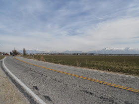
                                  The Tushar Mountains as seen from I-15 to the west.


-NOTE: The author, Lynn Arave, is available to speak to groups, clubs, classes or other organizations about Utah history at no charge. He can be contacted by email at: lynnarave@comcast.net  


Tuesday, October 22, 2013

Hottest Day Ever in Salt Lake? 107.1 degrees on July 13, 2002

  Salt Lake City's hottest  air temperature ever recorded was 107.1 degrees on Saturday, July 13, 2002.

The previous time it came close to being this sizzling

was 106.6 degrees on July 26, 1960.

 "Mercury climbs to 107 to smash all records" was a Deseret 

News deadline back then.


"Hot, hotter, hottest" was the headline when that record was 

broken in 2002.

Despite that single day heat record, the summer of 2013 was 

the hottest overall on record. There were not a lot of 100 

unmatched.

According to the Salt Lake Office of the National Weather 

Service, the summer of 2013 had the most number of days -

-54 -- with a high temperature of 95 degrees F or more.

Wasatch Front Canyon Winds History: They Aren't East Winds Everywhere

                            The narrow mouth of Weber Canyon can produce strong wind gusts.


Hurricane force east canyon winds along the Wasatch Front are nothing new.
In fact, from 1959 to 1999, there were 26 such occurrences of damaging east winds.
So, they averaged about every 18 months for 4 decades and then disappeared for more than 12 1/2 years until Dec. 1, 2011.
The damage from these winds was mostly so extreme, because it had been more than a decade since the Wasatch Front had any such wind events and so the damage came all at once, mostly from overgrown trees.
Then, another such wind event struck on April 9, 2013. And, they struck again on April 30-May 1, 2016. The latest episodes of these horrific winds was Sept. 8-9, 2020; January 18, 2021 and March 14-17, 2024.
Still more canyon downslope winds came on May 10, 2024 -- perhaps the latest they've ever blown into the spring season.

 The "new" average for these winds is more in line with about every 3 1/2 years now.
The year 1988 featured a record three such east wind events. There were also two such hurricane force canyon wind events in 1964, 1973, 1983, 1986 and 1997.
April 2, 1973 featured some of the strongest, sustained canyon winds. Those winds picked up a pole vaulting porta-pit mat and carried across Weber State University's Wildcat stadium as if it was cardboard.
We forget that these winds are a periodic part of nature along the Wasatch Front.
Technically, they are "downslope winds."
Northern Utah's "canyon winds," or "east winds" are simply legendary. 
However, depending on where you live, these winds are not necessarily east winds.
Although I built my cedar fence strongest on the east side, that was pointless, since strong east winds have never hit my house.
In fact, the Dec. 1, 2011 winds that struck my property were straight from the north. (And they broke 4 posts along my fence's northern side.)
I asked Dan Pope, a from Utah weather expert on KTVX-TV then (now he's on Fox-13), to address the question on wind direction and why "east winds" aren't always east winds.
His explanation is intriguing and worth repeating, especially since no TV weathercaster has enough air time to provide this much detail.
Dan Pope's answer:
These ... winds were "mountain wave" induced. But, the topography does force the winds to veer with distance; and due to local hills, canyons and location they can change as they move away from the mountains. They also come in rolling as they slam the ground (spinning counter clockwise).
In North Salt Lake, I have always noticed a veering to the north, because the hills by and to the north of Eaglewood Golf Course, that force the eastward track around them to flow southward.
These hills are also are northeast-southeast oriented, and with City Creek Canyon on the other side, the winds likely skip over the flat area above Meridian Peak and are pushed away from the hills, protecting some of the upper Bench of North Salt Lake from the worst gusts, while Bountiful, Centerville, Farmington and areas northward are directly in line with the Wasatch Mountains, and the "wave" effect.
When we have these kinds of winds, there is usually a low pressure spinning to our south. The upper level winds come from the east or preferably the Northeast. And, at the surface, the pressure is much higher in Wyoming and lower in Utah. In a low pressure like this, sometimes a little warmer air is wrapped in above the mountain tops. This creates an inversion at 12,000 or 13,000 feet, and keeps any wind from rising--and creates a Venturi effect. 
Plus, the Uinta Mountains line up directly east of Bountiful and Davis County, so all wind get pushed eastward towards the Wasatch mountains from extreme Northern Salt Lake County and Davis County northward.
Rule of thumb is that winds will be 2 to 4 times higher than at mountain top as they "roller coaster" down the slopes; and they will hit beyond the base of the mountains 1/2 to 3 or 4 miles out towards the Great Salt Lake. Then they fan out, and can go in multiple directions.
To the south of Davis County, they fan to the south (a north wind) and northward the can even come in from the SE if a person lives more than 3 or 4 miles from the base of the Wasatch. But, more often than not, these winds veer to the south away from the Wasatch, because the surface pressure is lower to the south.
There are certain locations near the canyons and at the base of the Wasatch in Davis, and counties northward, where these winds can be severe right at the base. Bountiful, Centerville and Farmington, as well as NE Ogden, Brigham City and even Logan fall into this category.

--------------------------
EAST WINDS WERE A PIONEER PROBLEM TOO:

Strong east canyon winds have been known to buffet the Wasatch Front, particularly Davis County, ever since the Mormon pioneers arrived in the late 1840s.
"East winds have come from time to time (in Davis County) ever since the people can remember, doing much damage to trees and roofs," states the history book, "East of Antelope Island," published by the Daughters of the Utah Pioneers.The first recorded incident of strong east winds comes from a diary of Daniel A. Miller, one of the earliest settlers in Farmington.
He recorded that the very first day his family arrived in the area -- the fall of 1848 -- there was a heavy east wind.
Early settlers created inventive ways to try to secure their roofs from these winds, but nothing seemed foolproof. One early Kaysville resident, John R. Barnes, made the east walls of his home four bricks thick to ward off canyon wind damage.
Prominent settler George D. Watt made a special wind storm shelter for his family, but he still had his home's roof blown off.
A strong east wind in the summer of 1854 actually performed a miracle. The canyon winds saved the day by blowing hordes of invading grasshoppers away from Davis County crops and into the Great Salt Lake, where they perished.
Hurricane-force east winds struck at least twice in the early 1860s, and the roof on the East Bountiful LDS Church had to be replaced twice.
After one such east wind, the Tuttle brothers from Bountiful jokingly inquired on Antelope Island if any missing hats had been found.
The east winds were a very feared and dreaded occurrence, especially in Farmington. It was canyon winds and water shortages that plagued many early Davis settlers the most.
Perhaps the saddest east wind incident took place in February 1864 when Elizabeth Rigby of south Farmington and her 18-month-old son, John, froze to death after being pinned against a fence by hurricane force canyon winds. Husband John Rigby had left his family to travel to Salt Lake City for medicine. Upon returning, he not only discovered the two deaths, but the home's roof was also blown off and 200 sheep, six horses, 10 cows and four pigs perished because of downed buildings and the frigid winds.
During a Nov. 9, 1864, visit to Farmington with Wilford Woodruff when the canyon winds were blowing, LDS Church President Brigham Young rebuked the winds in the name of the Lord.
Woodruff's diary reports that east winds did decrease substantially for some years afterward, perhaps as long as the late 1890s.
When Matthew Cowley reviewed Woodruff's diary in 1909 before its publication, he noted:
"In late years these winds have occurred in some of their old-time severity."
Strong east winds struck Davis County twice during 1896 and two more times in 1898. A fierce canyon wind in 1906 took the roof off the 2-year-old West Bountiful LDS Chapel.

Sources: Dan Pope, meteorologist, "East of Antelope Island" book, by Daughters of Utah Pioneers; "Weather and Climate" book, by Dan Pope and Clayton Brough.

(-Written by Lynn Arave and published in the Deseret News, April 23, 1999.)

Friday, October 18, 2013

When Straight Roads Aren't Straight in Utah

            The north end of 4500 West in West Point: notice the jag after the intersection.

                   Another look at the uneven intersection at 1800 North and 4500 West.

By Lynn Arave

Have you ever wondered why some roads don't line up?
When is a straight road not a straight road?
When it’s 4500 West Street (also State Road 110) in West Point, Utah.
Anyone who’s traveled this north-south corridor in northwestern Davis County knows it has a large bend in it on its south end, to the west, near 700 South and the Syracuse border.
They may also know it does not line up directly with a continuing segment of 4500 West in the northern edge of West Point, that travels north of 1800 North (State Road 37) into Hooper City. To continue further northward on 4500 West, a jag to the west of about 150 feet is required.

        At the south end of 4500 West Street is this bend that realigns it back to normal.


Another look at the 4500 West curve on is west end.


However, it is also clear that the extreme south and north ends of 4500 West line up, if they could be connected. It is only that long, middle segment, about three miles long, that is out of alignment and likely closer to being 4400 West.
How did this important corridor end up being mismatched?
“It has been that way since pioneer times, way back 100-plus years ago,” Max B. Elliott, Davis County Surveyor, said. “It is the road by usage,” he said of the section that’s out of alignment.
He speculated that some homesteads were in the way of having a straight road and over time that simply became the legal right of way as there was likely too much property to displace.
“There are other roads like that,” Elliott said of 4500 West, though it is the one most visible in its misalignment.
Howard Stoddard, 86, former West Point Mayor, said he didn’t know why the road was crooked.
“It has been that way all of my life,” he said.
Val Hinze, who has lived on 4500 West for more than 35 years, said while he has been keenly aware of the misalignment of part of the road, he too has never heard any cause mentioned.
Today, 4500 West is the most western north-south corridor in Davis County. Lacking any traffic signals or stop signs, it also remains the lone, free-flowing road on Davis County’s west side.
Although the exact cause of the crooked road can’t be identified, a further look at a history of that road and adjoining highways, contains some interesting information.
The 4500 West Street was first designated as a state road, U-195, in 1935, connecting U-37 with U-108 (today’s Antelope Drive).
Back in 1935, U-37 (1800 North or the “Clinton Road”) ended at 4500 West. It wasn’t until 1945 that the road officially looped into Hooper and past “Pig Corner” at its bend.
And, before Hill Air Force Base was established, 1800 North (U-37) used to go all the way east, up and over a sandy hill into Weber Canyon. So, it is more than a coincidence that this road lines up with the mouth of the canyon.
Elliott said the lack of direct access to Weber Canyon would have been cut off by Hill Field in the early 1940s.
The 4500 West Street was dropped as a state route for a time starting in 1947, but when it became a state thoroughfare again, it was renamed U-110, being 3.5 miles long, and at an elevation of 4,230 feet.
U-107, or 300 North Street, was improved and officially designated as a state road in 1931, and offered eastern access off 4500 West.

(-Originally written by Lynn Arave and published in the Syracuse Islander, March 13, 2013.)

Spanning Salt Lake's History: Eagle Gate


By Lynn Arave

MANY Salt Lake City motorists drive under a historic monument every day, likely without giving much thought to it.
Eagle Gate, which is at State Street and South Temple, has changed many times during its 146 years of existence.
As the entrance to Brigham Young's estate at the mouth of City Creek Canyon, it is located near where the pioneers homesteaded that first summer in 1847.
Consistent with his New England heritage, President Young fenced and gated the land for privacy and also for protection from City Creek flooding. It was designed by architect Truman O. Angell and Hiram B. Clawson.
The original eagle was carved by Ralph Ramsey and William Spring from five laminated wooden blocks and used an actual eagle that had been found in City Creek Canyon as its model. The monument weighed 500 pounds, had 16-foot-wide outstretched wings and rested upon curved wooden arches that used 9-foot-high cobblestone bases as their anchor. The eagle sat on a beehive and a star mount.


Large wooden gates closed the 22-foot-wide opening of the original Eagle Gate at night. Young had the Beehive House, Lion House, private offices, a flower garden, school, barns, sheds, greeneries, orchards and vegetable gardens in his yard. For many years, the gate not only marked the entrance to Young's property but also to City Creek Canyon, as the highway was then the canyon toll road, not State Street.
Fourteen years after Young's death in 1891, the gates were removed and the street was widened to two lanes. Soon after, electric streetcars began traveling the area and a greater height was needed to accommodate the overhead wires.
The eagle was then sent back East to be covered with a layer of copper, and new supports resting on stone pillars were added. The gate was also widened in a new design by architect J. Don Carlos Young.

It was remodeled another three times during the next 60 years and eventually became just wide enough for four lanes of traffic, but there was no extra room.
On April 18, 1960, a truck severely damaged Eagle Gate. The eagle and beehive were removed later that day. The Church of Jesus Christ of Latter-day Saints, which owned them, eventually gave the eagle and beehive to the Daughters of Utah Pioneers because the wooden portions had deteriorated and could not be remounted again. They are in the DUP museum today at 300 N. Main.
In succeeding weeks all the gate structure was removed. A time capsule dating to 1891 was found in one of the bases of the old support columns. For more than three years, there was no Eagle Gate at State Street and South Temple.
Architect George Cannon Young, a descendant of Brigham Young, began to design a new frame to support a new Eagle Gate. Artist Grant R. Fairbanks made a replica of the original bird out of bronze, though this one was larger, with a 20-foot wingspan and 10-foot-long body, and weighed about 4,000 pounds. The stone fence near the Lion House was moved 20 feet west to make room for a larger five-lane span.


State highway funds financed the project, but the LDS Church granted the state millions of dollars in rights of way for the project. By November of 1963, Eagle Gate — the one we enjoy today — was back.
"The Eagle Gate is famed throughout the world as an example of pioneer art and culture," C. Taylor Burton, director of Utah's Highway Department, said in 1963. "Millions of tourists each year visit Temple Square, the Beehive House, the Eagle Gate and other pioneer works in this area."
A large bronze plaque at the northeast corner of Main and South Temple says Eagle Gate has come to represent both Brigham Young and the pioneer spirit.
Today the gate has a 74-foot span.
However, even today's wider arch isn't immune to some traffic problems. A vehicle in mid-August 2005 bumped the arch's monument base, located between arches on the east side of State Street. This concrete structure was pushed off to the side, nearer the sidewalk.

(-Originally written by Lynn Arave and published in t he Deseret News, Nov. 24, 2006.)


-NOTE: The author, Lynn Arave, is available to speak to groups, clubs, classes or other organizations about Utah history at no charge. He can be contacted by email at: lynnarave@comcast.net  


Mormon Battalion gold 'bought' much of the Ogden area


      Ogden, as viewed through all the microwave apparatus, atop Mount Ogden Peak.

By Lynn Arave


IS the Ogden, Utah area worth $1,950, or about 103 ounces of 

gold?

Dutch colonists are often said to have purchased all of Manhattan 

Island, New York in 1626 from the local Indians for trinkets and 

cloth, worth only about 1.5 pounds of silver, or perhaps just $24.


Jump forward in time from that event, some 221 years, to the Utah 

Territory, in 1847, to a somewhat similar event in history.

Today's Ogden was the only place in the territory already settled 

by whites when the Mormon Pioneers arrived in July of 1847.

Mountain man Miles Goodyear and his family had built a fort (today's Fort Buenaventura) and cabins in what is present-day West Ogden in 1845-46, before the Mormon pioneers arrived.
James Brown, a Captain in the Mormon Battalion, under the direction of Brigham Young, used Mexican or Spanish gold coins, worth about $1,950 -- earned from service in the Mormon Battalion -- to purchase much of today's Ogden area.

                                         Captain James Brown

That price included: a fort, about 210 square miles, 75 cattle, 75 goats, 12 sheep, six horses (and a "$10 cat," according to some sources) from Goodyear on November, 24, 1847.
(Where Goodyear got that many cattle is another story ...)
Based on prices per Troy ounce of gold for that era (at least in the weight of gold), that purchase price might have equaled about 8 1/2 pounds (103 ounces) of gold paid by the Mormon Pioneers.
In today's current gold values, what the pioneers paid in gold could now be worth almost $136,500. (In today's dollar values, that $1,950 is only worth about $47,500, though).
This gold was Brown's own money, not only earned for his service in the Mormon Battalion, but also from some of his business enterprises in California. 
(Despite "owning" all of the Ogden area land, Brown never charged any settler for homesteading land there.)

             The historic Miles Goodyear cabin today, at 2104 Lincoln Avenue, Ogden.

Goodyear's deed (claimed with an alleged grant from the Mexican government) described the boundaries as:
"Commencing at the mouth of Weber Canyon and following the base of the mountains north to the hot springs; thence west to the Salt Lake; thence south along the shore to a point opposite Weber Canyon; thence east to the beginning."
By that geography lesson, the purchase likely stretched from Weber Canyon to Ogden Canyon (today's 12th Street) and to the Great Salt Lake in between.
(There is a hot springs near the Box Elder-Weber County line, but that’s northwest and so the purchase boundaries were more likely referring to the hot springs at the mouth of Ogden Canyon.)

    Much of the Ogden area as viewed from Ben Lomond Peak.        Photo by Liz Arave Hafen.

 So, the area included not just most of today's Ogden City, but also some of West Weber and West Warren, all of West Haven, Hooper, Roy, South Ogden, Riverdale, Washington Terrace and Uintah.
Also included would have been some of Davis County -- parts of South Weber, Sunset, Clinton, West Point and Hill Air Force Base.
Of course Goodyear almost certainly had no true deed to the property, or even a land grant from Mexico.
"So far as the land was concerned he had sold Captain Brown a wooden nutmeg!" is how the book "Beneath Ben Lomond's Peak" summarized the land transaction.
Goodyear was seemingly more than a capable mountain man, he was apparently a shrewd salesman and entrepreneur too.
This was the only such land purchase made anywhere by the Mormon Pioneers -- call it a payment for privacy.
As Goodyear moved out and took his family to Benicia, Calif., only some scattered Native Americans were left in the area. Goodyear’s  former home first became known as Brown's Fort, or Brown's Settlement. Soon "Brownsville" took hold as the name and held for several years.
The city was named for Peter Skene Ogden on Feb. 6, 1851, when it was incorporated.
Peter Skene Ogden was the brigade leader of the Hudson Bay Fur Company, who were in the Ogden Valley in the 1830s(but ironically who never set foot on the front side of the Wasatch Mountains into today's Ogden City.
(Can you imagine if Brownsville had become the name of today's Ogden?)
By 1860, Ogden had a population of 1,463 people, but was primarily a farming community.
Ogden really took off in 1869, with the establishment of the transcontinental railroad. Soon, Ogden became "Junction City," near where the Union Pacific and Central Pacific Railroads met.
Eventually, the equivalent of today's chamber of commerce adopted the motto: "you can't get anywhere without coming to Ogden!"
That was true as all passengers and shipments by train in the Mountain West went through Ogden.
Weber County today boasts more than 237,000 residents and the portions of Davis County in the Goodyear purchase have many thousands more. So, the $1,950 "purchase," more than 165 years ago -- legally necessary or not -- certainly appears to have been a great investment of sorts.


SOURCES: www.nma.org; www.ogdencity.com, "Beneath Ben Lomond Peak" book, by Daughters of Utah Pioneers; "The Utah Story" book, by Milton R. Hunter; "Weber County is Worth Knowing," by William W. Terry.

--Originally published by Lynn Arave in the Ogden Standard Examiner on Dec. 6, 2013.


-NOTE: The author, Lynn Arave, is available to speak to groups, clubs, classes or other organizations about Utah history at no charge. He can be contacted by email at: lynnarave@comcast.net  


Monday, October 14, 2013

Cathedral Valley: Spectacular Utah Badlands


By Lynn Arave

ABOUT 200 years ago, trappers and other trailblazers pushing into the American West began traversing bleak, torturous landscapes mostly barren of vegetation and browse.
They called these places "badlands." Nowadays, often as not, we call them "national parks."
A perfect example can be found in the spectacularly eroded backcountry northeast of Fruita and the Fremont River in southcentral Utah. There, in 1945, Frank Beckwith and Charles Kelly, the first superintendent of what was then Capitol Reef National Monument, christened an area of fantastically eroded cliffs, sandstone monoliths and panoramic views. To them, the scene seemed downright Gothic.
So they called it Cathedral Valley. There you'll find, among many other jaw-dropping formations, the Temples of the Sun, Moon and Stars.


This quiet remote place has a reverent atmosphere, filled with solitude and wonder.

"The landscape of South Desert and Cathedral Valley looks eternal," Rose Houk writes in her book "Capitol Reef: Backcountry Eden." ". . . But change is nature's universal theme.""It's spectacular and remote," observes Al Hendricks, superintendent of today's Capitol Reef National Park.
Cathedral Valley's sometimes atypical Colorado Plateau scenes are often depicted on postcards and in books, but getting there requires heading off the paved U-24 highway that bisects Capitol Reef, often to travel a dusty — and in wet weather, potentially treacherous — 58-mile loop that crosses the eerie Bentonite Hills, rises over the South Desert and descends into Cathedral Valley and the Caineville Wash . . . or vice versa.
Compared to the more popular Waterpocket Fold area to the south, not many people choose to make this trip.
"Very often, you may be the only one visiting them that day," Hendricks says.
The Cathedral Valley tour is a fascinating passage through the geologic eons, from ancient seas that laid down sandstone layers to not-quite-so-distant volcanic and ice ages that have left big basaltic boulders strewn about as if giants had been playing marbles with them.

The wonders along this backcountry loop greatly add to Capitol Reef's picturesque inventory. The park's better-known Capitol Dome, Hickman Arch and Grand Wash are familiar to most visitors because of their proximity to historic Fruita, Capitol Reef's headquarters. But the moonscape hills, plateau-top views, shimmering gypsum hillocks and pyramid-like temples in the park's northern sector are certainly worth taking in as well.
Overnight visits are possible, but a minimum of seven hours is usually required to complete the Cathedral Valley loop. The route also passes through some private land, where no trespassing is the rule, and winds in and out of national park boundaries and into Bureau of Land Management territory.


Here are just a few of the sights:

Fremont River Ford: This one obstacle, 11.7 miles east of Capitol Reef's visitor center on the loop's west end, probably deters many a potential backcountry tourist, even though the road beyond is generally OK for all vehicles with good ground clearance. The river crossing is shallow year-round (about 10 inches deep), except in spring runoff or after a rainstorm, according to the park's $1 "self-guiding auto tour" tabloid. Access to Cathedral Valley itself is possible at the other end of the loop, at Caineville Wash, 18.6 miles east of the visitor center — and the road there does not require a splash across a river, if you plan on going out the same way you came in.
Bentonite Hills: Their name sounds like a title for a Western novel: "These Bentonite Hills." From a distance, the mounds, about 8.5 miles from the River Ford, really do look otherworldly — like an artist's palette, splashed with gray and white and dark vermillion. Up close, the barren soil — "Plants can't take root here," Hendricks says — looks equally alien. Crackly when dry, like stepping on popcorn, it becomes gooey and slippery when wet. So this part of the loop is best avoided when the latter seems likely.

Cathedral Valley Overlooks:
A 1-mile hike from the loop road, 17 miles from the ford, offers a high view of the Temples of the Sun and the Moon. A spur road 27.2 miles along presents the panorama of Upper Cathedral Valley's monolith complexes.South Desert Overlooks: There are two major overlooks of the colorful South Desert, one about 14 miles from the ford, at the end of a short spur (the "Lower" overlook), another atop a high knoll 27 miles along (the "Upper" overlook), near the loop's summit. The views, high on a rising plateau, are to the south toward the Henry Mountains and the Waterpocket Fold, and they are something to behold.
Thousand Lake Mountain: A six-site campground is near the loop's highest point, 28 miles from the river ford, near where a Forest Service road heads off to Thousand Lake Mountain.


Upper Cathedral Valley:Towering above the sloping plain — sometimes 500 feet tall — the Entrada sandstone monoliths of Upper Cathedral Valley, 30 miles from the ford, rise in spectacular groupings above cracked-mud draws and pinyon-and-juniper lowlands.

Morrell Cabin: Mostly hidden by a small bluff in Upper Cathedral Valley, but near the loop road, the Morrell Cabin was used by stockmen, and today remembers the park's cowboy past. It was built in the 1920s by a ranching family.
Gypsum Sinkhole: A gigantic cliffside maw opens up below some cliffs at the end of a short spur road 33 miles from the ford. Underground gypsum deposits have eroded away, creating a sinkhole some 200 feet deep in places.
Glass Mountain: A shimmering mound off the Lower Cathedral Valley spur to the Temples of the Sun and Moon, 42.5 miles from the river ford (15.5 miles from the Caineville Wash intersection), has been dubbed "Glass Mountain." It is specked with unusually large flat selenite gypsum crystals, also known as "moonstone," according to the Park Service. The glassy rock adds to the unearthly setting when the Temples of the Sun and Moon are glimpsed in the near distance.


Temples of the Moon and Sun:
This is an intimate "Monument Valley." This is a place where you can drive right up, touch and ponder the layered pyramids in relative solitude. They offer a serene experience that's rare in today's overused national parks. The near-twins stand like sentinels, rising up to 400 feet high above the valley floor, but visitors can see other incipient temples along the cliffs nearby — the Temples of the Stars.

Spring and fall are Cathedral Valley's busiest periods, according to Hendricks. Summer, he says, is too hot for most visitors.
If there's a catch to Cathedral Valley, it's that it requires that minimum 15-mile, one-way drive along Caineville Wash's dirt roads to visit the magnetic Temples of the Sun and Moon.


"Our biggest issue here is flashfloods," Hendricks said.
He said the valley and the loop drive that accesses it are places where extra water and provisions are wise, because even the park rangers don't travel the road every day — and some days no one may come along to help a stranded traveler.
High-clearance two-wheel drive vehicles can sometimes travel the road safely, but probably can't do so now without a high probability of getting stuck. That's because additional work needs done on the road by the park service and Wayne County. More soil moisture is needed for that work to proceed.


"Four-wheel drive does come in handy here," Hendricks says. He believes deep pockets of dust are a particular hazard currently for two-wheel vehicles. "It's so dry. It's like driving in powdered sugar," he said.

-All photographs by Ravell Call.

(-Adapted from a Nov. 23, 2003 article in the Deseret News by Lynn Arave and Ray Boren.)


-NOTE: The author, Lynn Arave, is available to speak to groups, clubs, classes or other organizations about Utah history at no charge. He can be contacted by email at: lynnarave@comcast.net  


No Mirage: UDOT Operates a Seasonal Ferry on Lake Powell


                                                                                Photos by Ravell Call.
By Lynn Arave

THE Utah Department of Transportation maintains 5,840 total miles of road in Utah, including 971 miles of interstate highways. It also maintains a one-ship navy.
What? A ship in the desert? Yes. UDOT operates a ferry service seasonally across 3.1 miles of open water between Bullfrog Marina and Hall's Crossing on Lake Powell.
A wet, green state like Washington has dozens anddozens of ferries, but it seems unusual for the nation's second-driest weather state to have one.
The ferry, an extension of state Route 276, operates daily each spring and summer, weather permitting.
Maintaining a ferry crossing is the most feasible way to connect highways in this remote area.
The ferry, which will mark its 30th year of operation in 2014, has a vehicle capacity of 22 cars or any combination of cars, trucks, buses or other equipment that can fit on the deck. Passenger capacity is 150 for an approximately 25-minute ride.
A ride on the ferry is a scenic opportunity of its own, offering great views of Lake Powell and the surrounding area.The ferry saves about an hour in travel time for people headed to Halls Crossing, Bullfrog Marina and other areas. The only alternative route in the area is about 70 miles longer and means driving through White Canyon and Fry Canyon.
The service is not cheap. In 2005, it cost UDOT about $363,000 to operate the ferry, including a $100,000 charge to renew its license with the U.S. Coast Guard. UDOT almost canceled service in 2005, but increased the fees and reduced free rides for some groups.
When it was announced the ferry might close, people throughout the western United States sent UDOT e-mails requesting that it remain open. The Kane County Office of Tourism argued closure would negatively impact tourism, travel and emergency services in the area.
Besides tourists, area employees also regularly take the ferry. Some school buses use it to transport schoolchildren each day.

The ferry is an important link between two of Utah's most remote and rural counties — Kane and San Juan.
Regarding the unique nature of operating a ferry in a desert, Kitchen said among a flurry of local inquiries about snow removal, receiving a request for employment information on the ferry last month from a Coast Guard captain in New York seemed out of place.
Reservations on the ferry are not accepted. It is first-come, first-served. Fees are $10 for foot passengers and increases from there, depending on a vehicle's size.
 The schedule varies depending on the season.
Go to: udot.utah.gov and search for "ferry" for the latest schedules and prices.
(-Updated from a Jan. 24, 2009 article by Lynn Arave in the Deseret News.)