Thursday, February 11, 2021

The mystery of Utah’s ‘Mountain of Christ’: Monte Cristo


                         Monte Cristo Peak, center, 9,148 feet above sea level.


MANY decades before a viable seasonal highway (U-39) traversed its heights, the Monte Cristo Mountains, about 40 miles northwest of Ogden, generated mystery and fascination.
Hundreds of miners had passed below, to the northwest when the La Plata mines were in their 1890s heyday, but even the height of Monte Cristo was unknown in the early 20th Century.
“A grand trip to ‘Old Monte,’ Near but unknown solitude and grandeur in the Monte Christo (sic) Mountains” was an August 26, 1908 headline in the Logan Republican newspaper.
“It is distinctly a region of scenery and scenery on a scale of grandeur obtainable in very few places,” the story stated, dubbing it Utah’s “Garden of the Gods.”
“You may drive all day and meet no one, see no signs of habitation, unless it be a lone sheep herder’s tent,” the story stated, saying sheep men call the area “Old Monte” and that its greatest charm is solitude and being cut off from the world of humanity.
The Ogden Standard-Examiner of Aug. 11, 1910 also reported on the mystery of Monte Cristo. It stated that a party of Ogdenites were going to travel there to ascertain the height of the tallest peak there, Monte Cristo. Rumors had for several decades since the La Plata mining boon below, believed the summit to be between 11,000 and 13,000 feet above sea level.


                           The Monte Cristo Mountains as seen from Snowbasin.


The Monte Cristo mountains are where four Utah counties – Weber, Rich, Cache and Morgan all intersect and where the nearest towns are Huntsville or Woodruff, both about 22 bird-flying miles in any straight direction.
The Salt Lake Tribune of Aug. 18, 1910 reported on the group’s findings: “The height of the mountain which many in the party had been led to believe was inaccessible and one of the highest in the state, was found to be 8,950 feet above sea level.”
(Modern measurements have upped that elevation to 9,148 feet above sea level.)


                                   Monte Cristo and Utah Highway 39 in late May.

-Who gave the mountains and tallest peak their religious name, Monte Cristo, is also a mystery for the ages. According to the book, “Utah Place Names,” by John W. Van Cott, there are three different claims for the name’s origin:
1. Miners returning from California though the range resembled the Monte Cristo Mountains of California; 2. The name could have been given by early French-Canadian trappers; and 3. One of the early road builders in the area carried a copy of the book, “The Count of Monte Cristo,” which he read to his co-workers at night around the campfire.
However, since the 1908 Logan Republican story spotlighted to remoteness of the area – and no road was mentioned, but the name Monte was there – that leaves only credence for the first two origins.
(Note: “Monte Cristo” also means “Mountain of Christ” in Spanish.)

MORE HISTORY ITEMS:

-The Salt Lake Herald of July 11, 1909 outlined the report of one of the first known automobile trip to visit the North Rim of the Grand Canyon. This Woolley Automobiling Party went from Salt Lake City to Kanab/Fredonia and required 39 hours and 20 minutes of driving the 430 total miles before looking down at Bright Angel Creek from the Rim.
-The Ogden Bay Waterfowl Management Area was the first federally funded waterfowl management area in the United States, according to the Davis County Clipper of Nov. 26, 1976.
This area is located west of Hooper and is located on the delta of the Weber River, near where it dumps into the Great Salt Lake. Development there began in 1937 and includes 16,700 acres. The Hoard Slough portion to the south was developed 21 years later in 1958.


'Moki' Dugway: The most unforgettable/scariest road in Utah, but a view to die for?


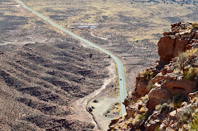
The heart of the Moki Dugway switchbacks.
                                                                                                   Photo by Ray Boren in 2018.

WHAT the upper Angels Landing Trail in Zion National Park is to hiking (scariest and most unforgettable), the "Moki" (sometimes also spelled "Moqui" or "Mokee") Dugway is the equivalent to highway driving in Utah.
Often known in San Juan County, Utah as "White knuckle hill," this three-mile-long graded dirt road with an 11 percent grade is unique in the State Highway system, it being a segment of Highway 261, from Mexican Hat to Highway 95 (south of Bear's Ears) or  a shortcut to Hite Crossing on Lake Powell.
This road climbs 1,200 feet up a sandstone cliff face and has no guard rails. The road is also so camouflaged into the cliffs, that you have to almost be on the switchbacks to see them.
The road drops 750 feet in just 440 yards.
"Going up or down is an experience not soon forgotten," is how the San Juan Record newspaper described driving the Moki Dugway on July 24, 1985. The Dugway has become one of the area's spectacular attractions -- and the nearby Muley Point Overlook doubles the eye candy.

Approaching the cliff the Moki Dugway climbs up is almost invisible until you're driving on it!
Photo by Ray Boren in 2018.


Supposedly, the future Moki Dugway slope is where Ute Chief Posey, though wounded, somehow came down the steep mountain and eluded law officers in the 1920s, intent on capturing the Chief for the final Ute uprising.
According to the San Juan Record of July 13, 2005, the Dugway's original name was "Isabelle Hill," though no one seems to know why, or when it switched to "Moki." Why some variations of the name spell it "Moqui" or "Mokee" is also unknown, but the shortest spelling is the norm now by common usage.

                            Even the sign at the top of the Dugway spells it as "Moki" these days.
                                                                                                                           Photo by Ray Boren.

The switchbacks begin at an elevation of 5,325 feet above sea level and top out at 6,525 feet.
The San Juan Record of July 1, 1998 proclaimed the road, "gives new thrills to the driving experiences of the southwest" ... and "provides access to an overlook on top that provides panoramic views of the area."
How did this Dugway come to be?
The Texas Zinc Corporation began to build the Dugway and a total  of 33 miles of road in 1955 from Utah Highway 95 south across Cedar Mesa to Mexican Hat, according to the San Juan Record of Jan. 7, 1965. Plagued by strikes, the road was finally complete in mid-1957 and it provided direct access from the high elevation mines down to a uranium mill at Mexican Hat.
The Dugway portion of the road alone cost $1 million (more than $9 million in 2020 dollar value).
The road was deeded over to the State of Utah in 1957 and officially opened as a state highway on Aug. 10, 1957. Yet, the other portions of U-261 were not paved until 1961-62.


     The Moki Dugway, a gravel segment, is that gap in the red color along Highway 316.


(Texas Zinc Corp. was bought by Atlas Corporation in 1963 and the uranium mill at Mexican Hat closed in 1965.)
San Juan County asked the UDOT to pave the road several times over the decades, including in 1971, according to the San Juan Record on Jan. 21, 1971. However, that never happened and the road remains gravel today.


(To bypass the Moki Dugway means drivers have to go along U-191 from Mexican Hat toward Blanding and then turn left onto U-95 toward Hite. The difference in distance is 30 extra miles without the Dugway, or about 37 minutes extra in travel time.)

The movie, "Chill Factor," (1999) filmed on the Moki Dugway.
Drivers going northwest out of Mexican Hat on U-261 see a high cliff in the distance and wonder where the road goes until the switchbacks come into view. It is likely motor home operators, big rig drivers and those afraid of heights who are unaware of the Dugway, surely question their sanity when they encounter the switchbacks going up or down.
Monument Valley High School  held the "Moki Dugway Hill Climb," a three-mile footrace on Dec. 14, 1991. Newspapers only contain that one single reference to the race being held.

One Google review of the Moki Dugway describes it as an "incredibly scary gravel road like going down the side of the Grand Canyon." Another recommends that only those unafraid of heights drive it, while some others thought it was over-rated.


Looking down a portion of the Moki Dugway to U-261 below is like looking out of an airplane.
                                                                                                             Photo by Ray Boren.

-"Skyway prospects delight San Juan" was a Dec. 29, 1968 headline in the Salt Lake Tribune. Reporter Carl E. Hayden stated that there was a plan to build a "sky railway" from the top of the Moki Dugway at Muley Point to Mexican Hat.
People would be shuttled from Mexican Hat and up the Dugway -- about 16 miles -- in buses and then be able to pay to ride a gravity powered cable car about 12 miles straight down as the bird flies to Mexican Hat.
This "would give tourists the breathtaking joy of ascending the Moki Dugway," according to the Tribune.
Of course, the skyway was never built and in today's era, with controversy over increased commercial access to the nearby Bear's Ears area, sacred to Native Americans, the development would probably never happen.

                      Near Bear's Ears, with Navajo Mountain looming in the background.
                                                                       -Photo by Ravell Call.

AT LEAST 5 ACCIDENTS ON THE MOKI DUGWAY:

Yes, people have died on the Moki Dugway. 
1. According to the San Juan Record of May 17, 1989, the first death happened about 1965. A man driving down the Dugway stopped and got out of his truck to urinate at the first turn from the stop. Lonnie Wilson, a passenger in the truck said he heard the driver say, "Oh My God!" from the rear of the vehicle and he was gone. His lifeless body was found on the next ridge below.

2. The newspaper said that scene was nearly repeated in 1989 when Howard Kinlicheeny, age 26, was in a pickup with friends and also stopped to relieve himself. He slipped off the road and fell 40 feet down. He suffered a severed spinal cord and a fracture on his femur.

3. The San Juan Record of May 11, 1994 carried the headline, "Mother dies in one-car accident." Jane Madison Navaho, 21, of Tonalea, Arizona, died when the car she was a passenger in went off the road near the top of the Dugway. She was thrown out of the vehicle after it plunged 60 feet and then rolled over her. Her husband, Dickie Navaho, was injured and had to extricated from the vehicle. The driver, Mary Stephens of Pasadena, Calif., was able to crawl out of the car. She was the only one wearing a seat belt. The Utah Highway Patrol said Stephens was driving too fast and lost control coming down the Dugway's first curve.

4. The San Juan Record of July 22, 1987, in a column by Doris Valle, recounted the tale of a driver who walked away from a fiery crash on the Dugway. Richard Nielson was starting to drive down the cliff's switchbacks in a uranium ore truck, probably in the early 1960s. The truck's brakes failed and then the steering, causing it to go over the first cliff coming down the Dugway. Flames erupted under the hood and Nielson's foot was caught by some crumpled metal inside the cab. The flames suddenly died down and started again, twice, with a few minutes in between. He finally got his foot unstuck and though shaken up, climbed back up the hill to the top of the Dugway. 
He "came up behind two other truckers who stood aghast, looking down at the smoldering wreckage below. They were ready to climb down to find Richard's body when he tapped one on the shoulder, 'What're waiting for?" he asked. "Let's get on down the road!"'

5. According to the San Juan Record of April 13, 2005, a family was almost to the bottom of the switchbacks that year when above them boulders the size of houses came loose and fell on the ledges above. They escaped injury, but a parked road grader higher up the Dugway was damaged by rock fall.


               Hikers to Angels Landing today hang on to chains, anchored to pipes.                                                                                                Photo by Roger Arave.
MORE HISTORY: The Washington County News of Dec. 24, 1925 stated that the first official trail from the end of the road in upper Zion Canyon to the Narrows had been constructed that year. There were 2 different trails, one for hoses and another for pedestrians, leading from the Temple of Sinawava to the Narrows to the Virgin River.
Also, the newspaper stated that the same year, 500 feet of pipe railing had been added "to render the climb to Angels' Landing safe for the timid person." That was something secure to hang on to during the climb up and down the steep path.

                                       Angels Landing with chains.
                                                                                                       Photo by Roger Arave.


Snow Basin used to host a sports car hill climb; Plus, Mount Ogden's original name and more ...


SNOW Basin has been site of more than ski races over the decades. For three years, from 1961-1963, there was a "Snow Basin Hill Climb" that raced sports cars on the Snow Basin paved road.
The course included 12 hills in its slightly less than two-mile-long event. It was also billed at the first such car race in Utah for some 20 years.
"100 sports cars to compete in Basin" was a May 29, 1962 headline in the Ogden Standard-Examiner. The Ogden Motor Sports Racing Association was the original sponsor of the race.
The first race in 1961 had to be postponed from May 28, to June 9-10, because of inclement weather.
Even though the race's third and final event, in 1963, attracted 1,300 spectators, it was never held again. A car did flip over in that final event, but no one was injured.


                        Looking down at Snow Basin from the Wasatch Mountain saddle.

After the Snow Basin Race was gone, the annual Moab Hill Climb each spring gained great popularity. (It was later renamed the Easter Jeep Safari.)
-Jump forward to July 1, 1967 and a different Snow Basin Hill Climb was held -- this one for bicycles. However, this race began at the mouth of Ogden Canyon, went east up the Canyon and accessed the original Snow Basin Road to the resort. This race also only lasted a few years.
-MORE HISTORY: The Civilian Conservation Corps ("CCC") helped build the road in Wheeler Canyon in the late 1930s and early 1940s. However, World War II halted their work before the road was completed. According to the Standard-Examiner of Oct. 27, 1955, the Utah National Guard finally completed the road. Several narrow sections of the canyon had to be dynamited to create a two-lane wide road. Today, the road is also titled "Art Nord Drive," in honor of A.J. Nord who was assistant regional forester for the U.S. Forest Service in the area and who pushed to complete the canyon road.


                              An old post card of the original dam in Ogden Canyon.

-BEFORE Pineview Reservoir was built (1934-1937), there was a much smaller reservoir located just west of the current Dam and at the head of Wheeler Canyon. "Big storage reservoir" was an Oct. 31, 1905 headline in the Salt Lake Tribune. This Utah Light & Railway Company and Ogden City water storage project provided electrical power, as well as summer water. Sometimes called "Power Dam," it was built from 1909-1910, was an average of 23 feet deep and held 21 million gallons of water. Its construction meant the road through Ogden Canyon had to be rerouted. This dam was drained and replaced by Pineview, located to the east.


                                     Mount Ogden from the southwest side.

-Ogden Peak was the original title for Mount Ogden Peak, according to the first U.S. Geological Survey through Weber County's eastern side in 1873. Next, according the Standard-Examiner of July 19, 1956, the peak was briefly dubbed "Henderson's Peak," to honor one of the men who conducted that first survey. A third temporary name, "Observatory Peak," was the moniker for the mountain during the time of the Malan's Basin Resort, at the end of the 19th Century. By the early 20th Century, Mount Ogden became the accepted name now listed on all maps.

 
                      Mount Ogden as viewed from the eastern, Snow Basin side.


When the Great Salt Lake was proposed as a National Park; Plus, more history

                      A view of the Great Salt Lake from Buffalo Point on Antelope Island.                                                                                                       -Photo by Roger Arave

THE Great Salt Lake is one of Utah's most well-known assets. However, few seem to be aware that in 1960 the briny body of water was proposed as a national park.
Of course, that status was never awarded, but Utah Senator Frank Moss did seek it, according to the Weekly Reflex newspaper of March 24, 1960.
Moss explained in the newspaper article that he never wanted the entire lake to be a national park, just a portion of the lake's shore.
He realized even in 1960, that industrial uses were impairing the lake and that developments also threatened it. While he didn't want to restrict any of the economic value of the lake, he was open to studying fresh water bay possibilities and more.

-MORE HISTORY: "Six stranded on Antelope Island get back safely," was an Oct. 27, 1932 headline in the Weekly Reflex newspaper. The men, Nephi Ross, Earl Stoddard, Paul and Francis Fowers -- all from Hooper, plus Frank and Charles Stoddard from West Point.
The men took a motor boat from the West Point Gun Club in hopes of rescuing a boat that was beached off the edge of Antelope Island a week earlier. That task was too difficult and their food supply ran out. They spent a night on the Isle and lit a fire to show relatives they were OK.
A Utah Pacific Airways plane was chartered and flew over Antelope Island in search of the. The pilot never found them, just a herd of about 25 buffalo.
The men finally freed the boat, but a storm preventing them from leaving the island until later in the day.


                                                                  Pineview Dam.                           Photo by Whitney Arave


-FACTS about a proposed Pineview Reservoir: 
Cost: $3 million.
Shoreline: 17.5 miles
Maximum depth: 56 feet in front of the dam.
Highways to Huntsville and Eden rerouted on the sides.
Source: Ogden Standard Examiner of Sept. 28, 1934.

-THERE was an obscure development while constructing Pineview Reservoir: For more than 40 years, the Utah Power and Light Company operated a small reservoir below Wheeler Canyon and found west of the new Pineview Dam. This old reservoir had to be drained and discarded and the old highway rerouted through it.
In addition trucks with water tanks hauled fish away as the reservoir was drained.
The Standard-Examiner of Oct. 7, 1934 chronicled some of this prep work and that a Civilian Conservation Corps camp was being erected near Huntsville.

-WHEN the Utah State Prison in Sugarhouse was slated for replacement, it eventually ended up in Draper, near Point of the Mountain. Another explored possibility was Antelope Island. However, another proposal is much more obscure -- west of Bountiful, near the Great Salt Lake.
According to the Weekly Reflex newspaper of Jan. 24, 1929, Salt Lake County was pushing for the prison to be moved northwest of the Cudahy Packing Plant (near today's Cudahy Lane).
A key problem with that proposal was that the Utah State Constitution required that the prison be located in Salt Lake County. So, Davis County would have to give the land to Salt Lake County for that to have ever happened. This proposal never took place and since Davis County is by far the smallest county of the 29 in Utah, it turned out well.

1914: When South Hooper, Clinton and South Weber sought to join Weber County


DAVIS County is by far the smallest of Utah's 29 counties. However, there was a failed proposal in 1914 that sought to put South Hooper, Clinton and South Weber into Weber County.
According to the Weekly Reflex newspaper of Kaysville on Jan. 29, 1914, petitions were circulating to make this proposal a reality.
"The principal reason given for the proposal change is the fact that all the residents of the three precincts named regard Ogden as their trading point and they therefore desire to transact all of their business there," the newspaper story stated.
At the time, this land was considered when one of the richest agricultural sections in the area. Also, West Point was not yet a named community, it primarily being called "South Hooper" at the time.


A portion of South Hooper and all of South Weber had actually at one time been located in Weber County, not Davis.
According to Utah historian Glen M. Leonard in the book, "A History of Davis County," an ecclesiastical disagreement resulted in the southeastern boundary of Davis County moving about one mile north of where it originally was established.
The county line moved south to the Weber River at the east end of Davis County. This meant that the Weber town of Uintah (previously called “East Weber”) was created to define what settlement remained on the north side of the Weber River.
The new Davis County town had also already favored the name “South Weber,” even though it was now in a different county, but at least it was indeed on the south side of the Weber River.
Jump ahead to 1877 and a related boundary change was made. 
(Perhaps someone looked at a map of Davis or Weber County and saw the unusual zag in the county line... created in the 1855 change.)
 This time instead of keeping the twist in Davis County’s border beyond South Weber, created by the 1855 change, the county line out west was now moved north about a mile to parallel the change made 22 years earlier in the South Weber section. This now made the Davis-Weber boundary line fairly straight from leaving the Weber River until it reached the marshes of the Great Salt Lake.
(Besides a crooked boundary, one other factor in favor of moving more Weber County land into Davis County -- by moving the Davis line northward on its west side -- was that Davis County was clearly still the state's smallest county of all. Legislators in 1877 may have felt the tiny county could use a little more land.)
The most significant effect this related boundary change created was that Hooper, originally known as “Muskrat Springs” and established in 1852, was now split.
This created “South Hooper” on the Davis County side and it was originally huge, going all the way south to today’s 1700 South (Antelope Drive), before the days of a West Point, Clinton and Syracuse. Over the decades as those three cities were established, “South Hooper” shrunk dramatically and only the section of unincorporated Davis County there is today was left. 
The South Hooper name also faded as the rural area only stretched from West Point at about 5000 West and State Road 37 (“Pig Corner”) about a mile north to the county line.
Yet, today some of these rural residents still consider themselves “Hooperites,” even though they reside in a different county.

The expedition that identified Utah's lowest point


      This is the Beaver Dam Wash in Arizona, Utah's lowest point is two miles north of here.


THE State of Utah prides itself on enjoying “Life Elevated.” Indeed, Utah has some of the highest average elevations of any state in the Union. Many know that the Beehive State’s highest point is Kings Peak at 13,528 feet above sea level. However, what is the lowest point in Utah?
Surprisingly, it is not St. George. However, the lowest point is in that corner of the State.
Travel some 325 air miles straight southwest from Kings Peak and ultimately drop 11,350 feet in elevation (about 2.15 miles) and you reach Beaver Dam Wash at the Utah-Arizona border. That’s the state’s basement at 2,178 feet above sea level.
(In contrast, St. George sits at 2,800 feet and Salt Lake City's Temple Square is at 4,327 feet above sea level.)
Just like Kings Peak, there are no cities or residences in the area of the Beaver Dam Wash. This is open wilderness. Littlefield, Arizona is the nearest town, about 10 air miles away, while St. George is almost 25 miles away as the bird flies. There is a ranch about six miles north – and some cattle sometimes roam the area -- but that’s it.
(The Beaver Dam Wash is also recognized for a wide variety of wildlife – desert plants, birds, lizards and mammals, etc.)
Before 2006, the majority of sources out there — Internet and books — listed Utah's lowest elevation all wrong. Some stated the low point was 2,350 feet above sea level and others even had it at an even 2,000 feet. The truth was about halfway in between.
It was a June 6, 2006 expedition by three Deseret News staffers who searched the area with a GPS and came up with the now accepted 2,178 foot elevation.

                  This is part of rugged road into the Beaver Dam Wash.

To reach the lowest point in the State, the trio had to drive five miles on a rugged dirt road and then hike two miles over trail-less terrain to the Arizona-Utah border, marked with a chainlink fence. After crossing back into Utah, they had to take dozens of measurements with a GPS in a myriad of low points until the lowest number was verified.
Hiking back to their vehicle was much more difficult than the trek in and far rougher than expected.

           Ravell Call surveys the water in the Arizona portion of the Beaver Dam Wash.

Not only is the Beaver Dam Wash Utah’s lowest place, but it sports an environment unlike anything else in the State. It is in the Mojave Desert, where Joshua trees, yucca, blackbrush, creosote and other desert plants thrive in a usually dry and scorching environment.

Looking east down into Utah's portion of the Beaver Dam Wash, where the State's lowest elevation is found.

The Deseret News consulted with Mark Eubank, chief meteorologist of KSL-TV, Ch. 5 at the time.
"In general, the lower the elevation, the hotter the temperature," Eubank said. "That is why Death Valley is the hottest place in North America — elevation near 200 feet below sea level. "There are no official temperature readings from Beaver Dam Wash, but I feel certain it averages hotter there than in St. George."
Eubank noted that Mesquite, Nev., to the southwest of Beaver Dam Wash, runs 2 to 5 degrees hotter than St. George most days.
Chris Gibson, meteorologist with the Salt Lake Office of the National Weather Service, agreed. "It (Beaver Dam Wash) probably is the hottest place in Utah," he said. He believed said temperatures usually drop 5.5 degrees Celsius for every 1,000 feet of altitude descended. On a hot, still day, he believes Utah's lowest point would be at least a couple of degrees warmer than St. George.
June 6, 2006 was a sunny hot day where Mesquite reached 106 degrees. By late morning in the Beaver Dam Wash, temperatures were already in the upper 90s. (One of the group’s thermometers measured 110 degree as they headed back to their vehicle.)

The 2,178-foot elevation is now the standard on Utah's official Highway Map.

While getting lost in the Wash was unlikely, especially when some power transmission lines go through the area and following them south would lead to the dirt road, there was no trail and following one’s footsteps back was next to impossible.
The 2,178-foot elevation is spotlighted too at the University of Utah's Natural History Museum. That figure came from this expedition in 2006, by three Deseret News staffers.

A shortcut through some heavy brush got you somewhat out of the sun, but slowed the trek down significantly and required some zigzagging and bushwhacking.
While the Wash was up to a half-mile wide in spots, loose sand and gravel, marshes and thick brush made walking difficult there.

      Ray Boren back at his vehicle after a scorchingly hot hike into the Beaver Dam Wash.

 In retrospect, the trio agreed that visiting the Beaver Dam Wash in winter, early spring or late fall would have equaled a much more comfortable visit than late spring did.
That 2,178-foot figure has recently become the accepted standard of Utah’s lowest elevation. It is now listed not only on the official Utah State Highway map, but is also highlighted in a high-low comparison in the University of Utah’s Natural History Museum.
How do we know that the elevation the Deseret News came up with is accurate?
After returning from their expedition, one of the three D.N. staffers consulted with Mark Milligan, a geologist with the Utah Geological Survey. He found on detailed quadrangle maps of the area that the lowest spot in Utah would be bounded by 2,160-foot and 2,180-foot contour lines.

Lynn Arave stands on the Utah side of the fence separating the State from Arizona, inside the Beaver Dam Wash.The State's lowest elevation was found nearby the fence.

"The border is much closer to the 2,180 contour and thus agrees with an elevation of 2,178 feet," he wrote in an e-mail to the Deseret News.
Milligan also indicated that 2,178 is as close an estimate to the low elevation as is possible, because the Beaver Dam Wash is very prone to flooding and its elevation can change.
Despite the hot temperatures in the Beaver Dam Wash, it isn't completely waterless. Some year-round springs keep year-round water there. The water runs as a small stream above ground at the end of the dirt road into the Wash. Walking north in the Wash, the water disappears and goes underground.
Utah’s Kings Peak ranks as the seventh highest high point among the 50 states. However, for low points in the United States, Beaver Dam Wash ranks fourth among the “highest” of low points. Only Colorado (3,320 feet), Wyoming (3,099) and New Mexico (2,840) have higher "low" spot points. (Montana rates fifth-place with an 1,800-foot low point and 21 states have sea level as their lowest elevation.)

                                 The GPS that located Utah's lowest elevation.

-To travel to Utah's lowest point, you really need a truck or four-wheel drive vehicle, unless you want to walk an extra six miles along dirt roads in the desert. The road is simply not passable for cars because of several dips in the road that exceed a regular car's ground clearance.
To get there, drive to Littlefield, Ariz., on I-15 and take Exit 8; go north on the old highway that leads to Shivwits and back into Utah; go past the Beaver Dam, Ariz., community (elevation 1,860 feet) and cross the Utah-Arizona stateline.
Next, look for a dirt road that heads left (west), 0.8 mile past the state line. Follow this rugged road southwest and then straight south for almost five miles into the Beaver Dam Wash. You will cross two cattle guards and spot several "Mormon pioneer trail" signs posted along the way. Ignore any side roads and always head due west.

                   Ravell Call photographs the GPS after it located Utah's basement.

Park near some large overhead power lines in a loose gravel area, near the perennial water flowing through the Beaver Dam Wash.
Be certain to carry plenty of drinking water and do not hike in the afternoon on hot days. Starting elevation at the parking area is about 2,076 feet above sea level.
Begin walking northward and ideally stay on the west side of the wash, carefully picking your route, about two miles, to a barbed-wire fence you can't miss. Cross over the fence and find the lowest point from there. (The above ground stream water disappears just before the fence line.)
Be sure to keep to the west of the Wash to avoid some thick brush. Ideally, retrace your steps as much as possible. The power transmission lines on the far east side of the Wash show the general way back.

-Lynn Arave, a reporter at the time; Ravell Call, a photographer; and Ray Boren, an editor, were the three Deseret News staffers who visited the Beaver Dam Wash and identified Utah's lowest point in 2006.
-The original newspaper story on this expedition was published Sept. 3, 2006 in the Deseret News.

      Lynn Arave at the Arizona end of the Beaver Dam Wash. Note the water in the wash.


Great Salt Lake tales of quicksand, unlucky equines and a phantom coyote


Is this pond of water along the sandbar to Fremont Island actually a pool of "quicksand" in the Great Salt Lake? Perhaps, as most of the rest of the sandbar has been dry in late summers recently.

IT has always seemed like quicksand in the Great Salt Lake was nothing more than a fanciful myth. However, according to the Ogden Standard-Examiner of May 28, 1939, two horses actually died in such “non-existent” quicksand.
“Horses die in quicksand of Great Salt Lake after driver missed stakes marking route. Ogdenite is haunted by experience as steeds drown” was the newspaper headline. Mike Boam of Ogden was driving a light rig, powered by horses, to travel to Fremont Island over an underwater sandbar. This route was often used in the 1930s to travel to the 2,943-acre Fremont.

                 In 1944, two horses pulled a wagon over the sandbar to Fremont Island.


           These men rode horses across the sandbar to Fremont Island in the 1940s.

Boam said that without warning his two horses “stepped into a patch of quicksand” and “several hours of labor failed to extricate the animals.” He had to wade about five miles through knee-deep brine along the “salty highway” to reach the mainland.

             Taylor Arave pauses at a pond of water along the sandbar to Fremont Island.

When he reached his home in Ogden he was exhausted, but could not sleep. “The look in the eyes of those horses when I left them wouldn’t let me rest,” he told the Standard-Examiner.
By the following day, both horses were dead, “victims of their own exertions and the brine they had drunk to quench their thirsts.”
Quicksand is simply sand inundated with water and where the liquid can’t escape, so while the animals didn’t sink out of sight, they were trapped in a sticky mess.
(I’ve walked that same sandbar to Fremont Island twice, when it was above water and mostly dry. Still, it wasn’t a straight path and at least once I had to curve around a pond of standing water.)
Also, in 2020, the Diesel Brothers, who used to own Fremont Island (before they sold the isle to a non-profit group) reported in a YouTube video
https://www.youtube.com/watch?v=ORFbOW027iM&t=167s&ab_channel=HeavyDSparks

 that some of their tractors and equipment had become stuck in “quicksand” along the Fremont Island sandbar. They were finally able to remove them, with great difficulty. "Peanut butter mud" was one of their descriptions of the briny, wet sand.
Sadly, there are other horror story for horses involving Fremont Island. When I first visited Fremont Island in June of 1982 by canoe, it was hard not to notice a large herd of ponies that were frightened by my presence and they galloped to the far west end of the Isle.

                            Looking across the south end of the sandbar to Fremont Island.

I had always assumed during later visits to the Island that the missing ponies must have been rounded up and removed. (There were a few other horses living on Fremont in 2006, when I was visited there, though.)
However, now I realize that while many of the ponies were removed, 40 of them were shot and killed on the Island.

                                  Several horses were grazing on Fremont Island in 2008.

An Associated Press story from March 22, 1988 states that the Idaho rancher who was leasing the Island at the time shot them, because the cost of removing all of them was prohibitive and they were over-grazing the Isle and he was going to put sheep there. He was able to capture and remove about 100 of the ponies by barge, but the remaining 40 were too hard to catch.
A private pilot flying over the Island had spotted the carcasses. The “welsh” ponies were placed on Fremont Island in the late 1950s, as part of a failed plan to make a recreational development on the Island. So, the animals soon became wild.
-Horses and sheep weren’t the only animals to inhabit Fremont Island. For more than two weeks in the mid-1940s, a “Phantom” coyote escaped extinction from hunters.
The coyote, who was believed to have hitchhiked to the Isle on a rare chunk of iceberg in the Great Salt Lake, had killed some 15 of the 800 sheep grazing there.
An army of dogs and 20 armed men failed to kill the coyote during multiple attempts.
“Phantom of Isle still eludes dogs” and “Phantom Coyote has hunters marooned in Lake” were two headlines in the Standard-Examiner, from March 26 and March 29 of 1944, respectively.
High winds not only caused dogs to lose scent of the coyote, but they prevented the hunters from leaving Fremont.

“Hunters again foiled in Phantom Coyote chase; New expedition scheduled” was a March 31, 1944 Standard-Examiner headline. Hunters joked about needing to use a silver bullet to stop the animal, as numerous regular bullets had proven ineffective.


Finally, on the 15th day of the hunt, “Island Coyote killed in lake waters” was the headline on April 4 in the Salt Lake Tribune. A bullet had finally wounded the coyote and so it jumped in the lake and tried to swim away. A speedboat caught up to him and he was hauled aboard and killed.
Four other coyotes had been speedily killed on Fremont Island in 1942 after they had killed numerous sheep, but none were as elusive as the phantom.


-The most famous part of Fremont Island is the historic cross that Kit Carson carved on the north end on Sept. 9, 1943.
Only about six inches long, this Christian relic was left during the first government survey of the Great Salt Lake and Island. Writings of the exploration prove Carson made the cross, though uncertainty about its origin swirled into the early 1940s.
“New speculation arises about Island cross” was a Nov. 2, 1943 headline in the Standard-Examiner. This story questioned the cross’s origin and speculated that a bored sheepherder in the 1850s had created it.
However, soon after it was universally accepted that Carson was indeed the sure author of the cross.

Note: Fremont Island is now owned by the State of Utah, after more than 150 years of various private owners.


Coral Pink Sand Dunes was ‘Sahara Desert’ in 1943 -- And more history


                                A 1998 photograph of the Coral Pink Sand Dunes/


THE Coral Pink Sand Dunes is truly Utah’s mini version of the Sahara Desert.

Decades before Little Sahara Recreation Area, Coral Pink gained world-wide fame through Hollywood by actually depicting the Sahara Desert in movies as early as 1943 – all this without “Sahara” in Coral Pink’s name.

“Movie Company awaits approach of spring to resume filming ‘Battle of Africa” was a January 1, 1943 headline in the Salt Lake Tribune.

(Battle of Africa was a just a part of the movie being filmed at Coral Pink. The film was actually titled “Sahara.”)

In 1942, the State of Utah had constructed the first road off Highway 89 into the Coral Pink area. Hollywood was eager to showcase Utah’s colorful, sandy area.

                                               Kids playing at Coral Pink Sand Dunes.

“At any rate, coral pink sand dunes of southern Utah are a pride and joy of Hollywood producers,” the Tribune story stated.

Coral Pink was designated as a state park 20 years later, in 1963. It is located 27 miles northwest of Kanab in Kane County. It comprises 3,730 acres, including some 2,000 acres that are wholly sand.

(In contrast, central Utah’s Little Sahara Recreation Area, though much larger, at 60,000 acres, was not developed until 1976 and lacks such colorful sand.)

-During Utah’s Centennial of 1947, Kanab was often referred to as “Utah’s Hollywood.”

Indeed, the Piute County News of Junction, Utah, published a widely distributed graphic for the Centennial by the State of Utah that stated on June 6, 1947, “Everybody in Kanab, Garfield County, is a potential movie actor, when film companies come to use the scenic grandeur of the southern Utah country for location of movie westerns. Even businessmen close up shop to act as extras.”

(However, eventually Hollywood crews began bringing with them armies of personnel, including cowboys, for their movies, leaving most of Kanab’s 1,500 residents without much of a chance at movie work.)

-Harry Sherman, a Hollywood producer, chose the Zion National Park and Kanab area for scenes in a new movie, “Ramrod” in 1947.

 In the Salt Lake Telegram of February 6, 1947, Sherman said, “We spent weeks surveying the west by air and decided on Utah as having the greatest scenic grandeur of any area we saw.”

-How capable were some of the Hollywood actors that portrayed cowboys in actual cowboy skills? Some were really good.  “Hollywood turns actor to cowboy” was a November 16, 1942 headline in the Ogden Standard-Examiner. The story reported that actors Glenn Ford and Big Boy Williams were in Kanab filming “The Desperadoes” movie, in the summer prior, and they decided to enter a local Kanab rodeo during their off time, The two actors ended up winning the “rescue race” event at the rodeo, proving some real-life rodeo skills.


-MORE HISTORY: The 64-mile road from Kanab, Utah to Page, Arizona was primarily constructed in the late 1950s, in conjunction with the Glen Canyon Dam project. However, this highway wasn’t always Highway 89. According to the Salt Lake Tribune on August 2, 1959, the highway’s original designation was U-259 on the Utah road section and highway number 189 in Arizona. It was on August 1, 1959 when road crews in both states began using U.S. 89 as the highway’s consistent title. At the same time, the former Highway 89 road from Kanab south to Bitter Springs in Arizona was re-designated as Alternative U.S. 89.