The sign at the edge of the parking lot.
The station where hikers are checked in and permits are taken.
THE Kanarraville Falls, a 5-mile roundtrip hike, is the hottest scenic rage in southwest Utah these days.
Indeed, in 2021, the hike sold-out for most of the summer in early May ...
Fueled by Kanarra Creek, this small slot canyon named Kanarraville Canyon, was a secret known to only locals for many decades. (Kanarraville is a small town about 13 miles southwest of Cedar City, along I-15.)
The first section of the trail is a brisk uphill on an old road.,
An exhaustive old newspaper search on the waterfalls reveals nothing until the 21st Century.
Looking down on the trailhead parking lot, with 2 sections and the restroom in between.
Indeed, "Best-kept secret becomes nightmare," was a June 25, 2017 Associated Press story in the Daily Sentinel newspaper of Grand Junction, Colorado and many other western newspapers that summer.
The S.P. story said the first time that town members noticed that their little slot canyon was no longer a secret was on July Fourth weekend of 2004, when 75 cars were crowded into the trailhead's parking lot.
Twin Kanarraville City water tanks after the trail levels out for a bit.
Another warning sign about being cautious on the rugged trail.
The Bureau of Land Management Sign, just before the first chance to cross the stream.
The first time the trail crosses Kanarra Creek.
How did the community keep it secret for so long?
"Very carefully," responded the ticket taker/security guard at the gate to the trailhead.
A hiker from Ohio said he was told that when the Zion Narrows were closed due to high water in 2004, that's when National Park Service , who knew about the smaller canyon, referred hikers to Kanarraville -- and it took off from there. The secret was out and social media exploded its popularity.
The early trail has some uphill, downhill, etc., as it goes back and forth.
Finally! The actual mouth of the canyon.
Kanarraville Falls is indeed a mini Zion Narrows experience.
The second stream crossing and where most walk in the water.
The final sign along the trail, adjacent to the fenced-off City's well.
Walking in water is now a complete necessity.
The first mini Zion Narrows experience!
Kanarra Creek is the town's main source of drinking water (along with a spring near the creek) -- and therein lies a big concern regarding pollution. Gates were placed along a road leading to the mouth of the canyon, to prevent parties from being held there, where some had hauled couches and other amenities up the mountain.
Narrow going here and an excellent experience.
The ladder is reached here. It is not as bad as it looks, but go slow and make sure you have both hands free when climbing. There is a sturdy chain to grab and hold onto near the top. Mist may hit you.
A closeup of the ladder, with metal rungs. Be sure to slowly descend on the return trip, turn around, with your face facing the ladder.
A view when the ladder is a crowded place, with a line.
Looking down on the ladder climb.
By the end of the 2015 hiking season, more than 40,000 people had been counted as visiting the falls. Then, Kanarraville City decided to pay for an actual parking lot at the trailhead. Then, they charged $10 a person to hike the trail, to fund the improvements.
In 2016, the parking lot grossed $95,500 in fees.
As of 2021, that fee is $12 a person and there is a limit of 150 hikers per day. Finding the trailhead is easy, as the City has road signs posted in town.
This is actually the most dangerous part of the Kanarraville trail. You have to scale the logs and scramble up large boulders above that. Not only can the timbers and rocks be wet, but there's only a rope on the very bottom section to hold onto.
Going up!
Restrooms are water are available at the trailhead. Sturdy sandal shoes or aqua shoes with good tread are a plus along this path, because you are walking in water most of the time along the upper route. Also, the taller a hiker is, the easier some of the scrambling on this hike is.
One hiking pole a person, is also a wise idea, to help maintain balance and test the depth of the water ahead in the deeper pools.
A considerable amount of scrambling is required along the upper portions of the trail. Thus, children 10 and under, require assistance and supervision along the way. In fact, though much shorter than the Zion Narrows, the 700-foot elevation change and the scrambling make Kanarraville a harder hike than the Narrows.
The second and final waterfall. Do NOT attempt to go above here.
Personally, I would not take any kid under 12 on this hike, all the way to the second waterfall vs. Kids age 8 and older usually do fine on a day hike of the Zion Narrows.)
The first 0.8 of a mile along the Kanarraville trail follows an old canyon access road and crosses the stream twice. With its up and downs, that is endurance wise, a very difficult portion of the trail.
A closeup of the second waterfall.
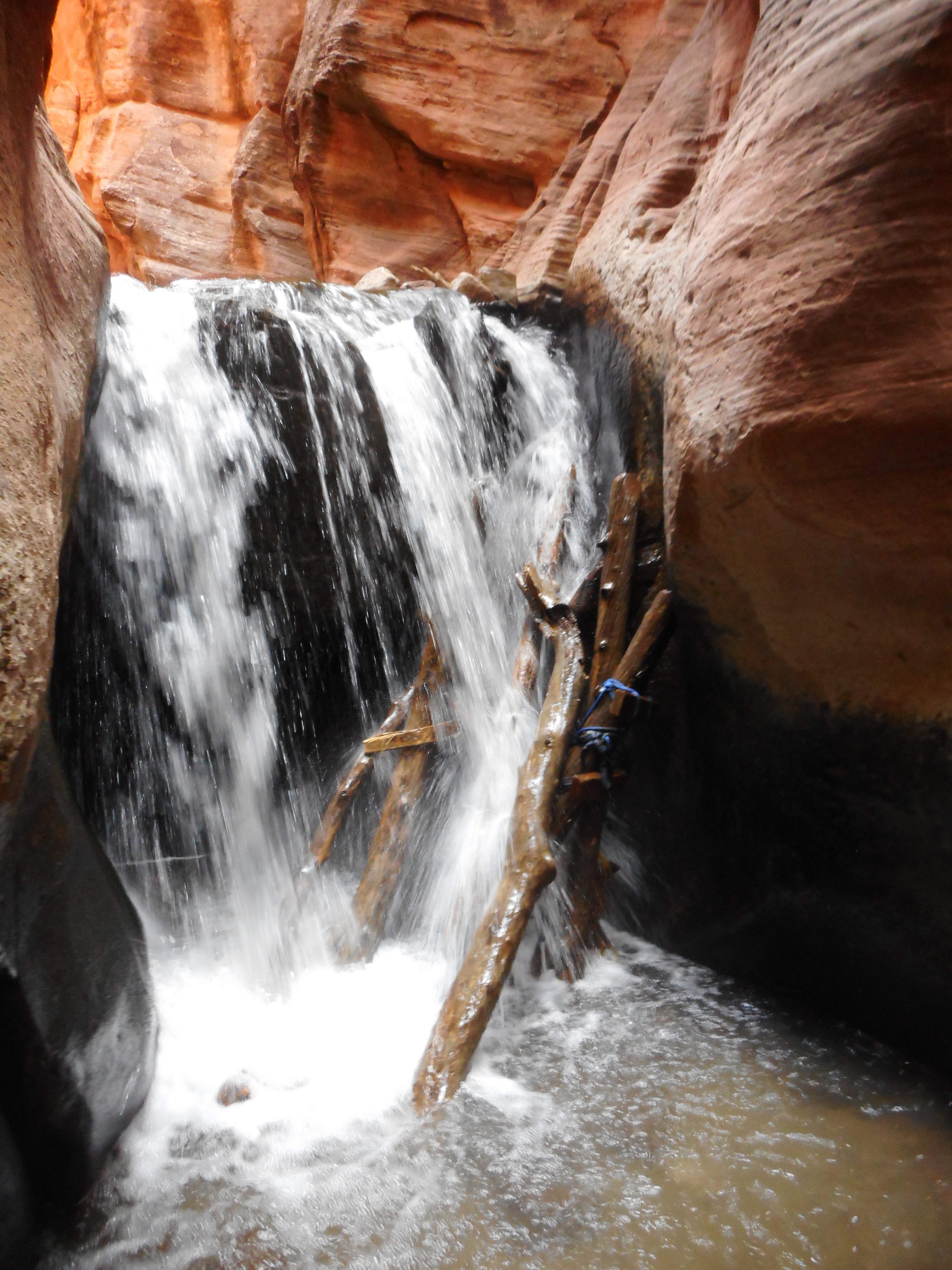
The first waterfall is 1.6 miles up the trail. A 15-foot ladder with metal rungs, but no handrails, must be scaled to continue from this point. Although it may appear challenging, the ladder is firmly secured in place, though nearby rushing water splashes over the ladder. (Returning hikers will best descend this ladder backwards and feet first.)
At 1.7 miles out is a spot with several logs and a tall boulder that must be climbed. This is where many injuries from falls have occurred on the trail. There is a rope attached to the lower portion of this spot, but not the upper part. (Having an anchored chain there could reduce injuries, but the City has no done that.)
The second waterfall is 1.9 miles up the trail. It is preceded by the narrowest section of the canyon, that also has the deepest water.
With one hiking pole, traversing up and down on the stream walk is so much more sturdy.
(In a mid-May of 2021 Kanarraville hike, the water depth never quite reached my knees. With a lot of photo taking, the hike lasted 4 hours for my group.)
Hikers should not try and go beyond the second falls.
Some sections of the trail have multiple path options for short stretches. Sometimes it is also a gamble on which is easier -- walking in the stream, or taking a rock side path.
In addition, to dangers from falls, rattlesnakes also live in the area and so look out for them. (My group heard a rattler on the hike nearby at about 1.4 miles up the trail, but did not see the reptile.)
Prior to the public discovery of Kanarraville Falls, the town of Kanarraville's claim to fame was that in the early 1960s, some California residents camped near the mouth of Spring Creek (one canyon south of the Falls Canyon). The group of some 26-plus residents, spent more than six years there, pioneering and living off the land.
Starting the hike by mid-morning means you will have some sun shining down to highlight your photographs, assuming you reach the narrow sections by early afternoon.
Small gold deposits were also found in the mountains east of Kanarraville in 1939, according to the Salt Lake Tribune of Feb. 3 that year.
-Kanarra Creek also caused some flooding in town during the spring of 1912, according to the Iron County Record newspaper of May 17, 1912.
Two people can barely walk by one another in these narrow sections.
-Kanarraville is named for a local Piute Indian leader from the 19th Century. This band of Native Americans frequently camped near where the town is today.
-Kanarraville Falls is on Bureau of Land Management terrain, though the City administers it, because of watershed concerns.
-No dogs are allowed on the trail.
-Kanarraville residents also have no easy access to the trail. They must, like everyone else, secure a reservation and pay the fee. (However, we observed two different hikers, both with dogs, who were allowed access through the gate and yet only went less than a mile up the trail. They might have been locals?)
Even with only 150 hikers a day allowed on the trail, it can be crowded at times ....
For trail fees, information and reservations, go to:
https://www.kanarrafalls.com/
AND, yes accidents have happened to hikers on the Kanarraville Falls trail. So, be careful there.
Some examples:
-"Teen falls 60 feet at Kanarraville Falls," was a May 16, 2013 story in the Daily Spectrum newspaper of St. George. The 16-year-old Las Vegas boy had to be rescued out of the canyon and suffered several broken bones. The boy was attempting to hike up a slippery slope to see where the water originated above a rock.
-"Injured hiker expressed gratitude for search and rescue's response," was an Aug. 3, 2004 headline in the Spectrum newspaper. A young woman from Arizona broke her leg after falling near one of the canyon's two waterfalls.
Take only photos on your Kanarraville hike and haul out any trash.