NOTE: This story is most suitable for members of The Church of Jesus Christ of Latter-day Saints, given the depth and extensive details provided therein.
By Lynn Arave
IT took 40
years to build the Salt Lake Temple, but Ogden had to wait almost 125 years
since being settled before it was blessed with an operating temple.
Then, there was the 3 ½ year gap of no temple again, as the structure
was almost totally rebuilt, from 2011 to 2014.
Elder Jeffrey R. Holland of the Quorum of the Twelve said, "It's not all bad to have a temple closed for a time," at the second re-dedication session of the Ogden Temple on Sept. 21, 2014.
He then said you may not take such a temple for granted and appreciate it more, once it reopens.
Yet, why did Ogden, Utah's second-largest city for well over a century, have to wait more than a century for a temple?
Well, it was simply because it was "Ogden."
Yes, Ogden was that "railroad town" that brought the liberals, the unions, non-Mormon mayors and more into Northern Utah.
Read any old Utah newspapers before the 1970s and it is clear that Ogden was not generally favored by Salt Lake County residents, nor by most General Authorities of The Church of Jesus Christ of Latter-day Saints either.
Ogden and Salt Lake also competed for many things over the years, from the railroad hub status of the Intermountain West, to the Lucin Cutoff and more.
(Ironically in the 21st Century, it is Salt Lake City that is far more liberal than other areas in Utah.)
First
settled in 1847, Ogden area church members actually helped construct and
finance the Salt Lake Temple, which was completed in 1893.
By the early 20th Century, church members were eager
for their own temple.
Indeed, “Ogden to get temple, Mormons are told,” was a big headline
in the Ogden Standard-Examiner newspaper on Dec. 13, 1920.
Church members at the North Weber Stake quarterly conference were
informed then by Church Patriarch Hyrum G. Smith that Ogden would have a temple
in the “near future.”
Patriarch Smith mentioned the overcrowding in the Salt Lake Temple
and challenged members to be ready for new construction of both a tabernacle
and a temple.
However, in 1921, Church
President Heber J. Grant made a special visit to Ogden and left indicating it
was not the proper time to have a temple there.
An
article in the Deseret News on May
16, 1921, reported: “A temple site was inspected in this city early Sunday
morning by Presidents Heber J. Grant and Anthony W. Ivins, together with local
Church officials.”
Today's 30th Street and Tyler sign, just southeast of Ogden High's stadium.
The Joseph
Clark Family had approached the Church about receiving a donation of land,
near 30th Street and Tyler, with just one condition – that an Ogden
Temple be erected on the property one day.
This 30th Street and Tyler land already had a religious history: In the year 1890, a Methodist University, dubbed as “Utah University,” was being built at the same address.
The entire first floor of that university’s main building was built by 1891, before financial problems and some national shakeups with the Methodist Church doomed that project.
The land eventually was returned to its original owners, the Clark Family, who then 30 years later wanted to donate it for a temple site.
Talking to Ogden resident Carla Vogel (age 82 in 2014 and who grew up at 32nd Street and Iowa in Ogden), she said her father knew the Clark Family well and always maintained the actual site the Clarks had in mind for an Ogden Temple was on the hill and to the east above 30th and Tyler -- AND actually where the eventual St. Benedict's Hospital would be opened in 1946.
She said that site meant a large portion of the city would be able to see the temple.
(Likely the reason the 30th Street and Tyler address was given in the articles, was because in that 1920s era, there was likely no real development above and to the east of that location. Also, with Ogden High School located in this same area today, would an Ogden Temple there have meant the high school, which opened in 1937, might have been built elsewhere? Possibly ...)
The 1921 Deseret News article also stated:
“A movement has been on foot for a temple for
this city for sometime past, owing to the great amount of activity of Church
members in genealogical and temple work and the fact that only limited numbers
can now be accommodated at the Salt Lake Temple. President Grant … announced that
from $2 million to $3 million were now on application for other purposes and
there was no telling when a temple could be built in Ogden.”
President
Grant also lectured Ogden area church members, proclaiming that if every member
paid a full tithing, many more temples could be readily built, like one in
Ogden.
Furthermore,
President Grant identified Ogden’s Lester Park (663 24th Street,
where today’s Main Weber County Main Library sits) as better suited for a
temple site.
One of those
church planned projects, a Deseret Gymnasium in Ogden, was already on the
drawing board, and was completed in 1925.
Area wards
were assessed amounts to pay for the Deseret Gym and it was implied that after
that debt was paid, a temple would be next to come.
What? A
gymnasium before a temple. History does contain some perplexing issues at times
….
More than
three years later, on May 7 1924, the Standard reported that the Associated
Clubs of Ogden had written to President Grant about trading Tabernacle Square
Park (site of today’s Temple/Tabernacle) for Lester Park. Purpose of the
trade was to provide “a suitable site for an Ogden temple.”
That
proposal was also turned down by the Church.
Again, this illustrates how LDS Church leaders did not favor the area, likely letting the liberal non-Mormons in Ogden supersede the fact there were many faithful Church members residing there too.
In the early 1890s, the LDS Church had actually given Ogden City the deed to the property that is now Tabernacle Square. However, the city decided it could not properly care for the property and it was given back to the LDS Church a few years later.
A report in the Standard on Dec. 20, 1893 stated: “The city gives it up. City Council gives back the Tabernacle Square to the church.”
In 1929, the Great Depression hit and in late 1941 World War II came along -- two other factors likely not in Ogden's favor for gaining a temple.
On February
12, 1956, Ogden did receive a new Tabernacle, the last such new tabernacle to
be built in the church (not counting the future Conference Center in Salt
Lake).
But not even having Church President David O. McKay in the 1950s hailing from Ogden Valley seemed to help Ogden's temple void very much.
Through the middle part of the 20th
Century, Ogden area church members were actually a part of the Logan Temple
District and some wards/stakes would charter evening bus trips to that temple
in the 1960s.
That was a difficult trip in winter, with Sardine Canyon to traverse into Cache County.
By the mid
1960s, rumors of Ogden having the next new temple abounded.
Sites in North Ogden, northwest Ogden, the mouths of the canyons, near Weber State College, and basically much of the east bench were also investigated as possible temple locations.
Many sites were unsuitable, because they were not available for purchase.
In the end, the three finalists were these sites:
1. Tabernacle Square.
2. The property where
the future McKay-Dee hospital at 39th and Harrison Boulevard would stand, across
from Weber State University.
3. The top of 9th Street (east of Ben
Lomond High).
(Regarding the third choice, Charles C. "Chick" Hislop, former Weber State University cross county/track coach, said that was his father's property. He said his father always relished that his land was in the top three.)
With the
railroad industry – previously Ogden’s bread and better business shrinking –
some downtown business leaders also heavily lobbied the First Presidency to
have the temple built downtown, instead of on the hillside.
That effort was really not required as Church leaders chose Tabernacle Square on their own as the new temple site.
Ogden’s temple location was officially announced on
August 24, 1967 for downtown Ogden on Tabernacle Square.
Tabernacle
Square in Ogden was designated by Brigham Young when he laid out the city
during his first visit there in the fall of 1850.
Brigham
Young chose the site for the Salt Lake Temple himself and he also chose the
block for a Tabernacle in Ogden, that later became the temple site too. So, essentially President Young chose the Ogden Temple site indirectly.
The main reason why
Ogden and Provo were to receive temples was actually not the reason previously
given in church publications.
The true reason was that
Church leaders had first planned to simply expand the Manti Temple, which
served Utah County and the Logan Temple, that served Weber County.
It was only when
church leaders realized how costly that plan would be – in that grandfathered
status’ of those historic temple not being up to current building codes – that
they suddenly favored a plan for new temples in both Ogden and Provo.
(Also, the fact that the Church started a building committee in the mid 1960s helped get better consistency and structure in church temples and chapels.)
Thus, it came down to dollars and the Church could built two new temples for far less than it would have taken to expend the Manti and Logan temples.
Emil B. Fetzer, Church architect, was given
the assignment to draw up plans for the new temples.
Brother Fred A. Baker,assistant committee chairman over all LDS Church buildings at the time, said President McKay "lit up like a Christmas tree" when his two counselors proposed an Ogden Temple, instead of expanding Logan.
(Mark B. Garff was the committee chairman and third member of this original church building committee.)
Fetzer was told by the First Presidency that even though the temples
must accommodate large numbers of people, the costs must be kept at
appropriately reasonable amounts. The temples were not to be as large or
expensive as those in Oakland and Los Angeles, but they were to be full-size
temples and not to be confused with the smaller temples of limited capacity,
such as those built in New Zealand, Switzerland, and England.
In addition, the Provo and Ogden Temples would not have solemn assembly rooms, no multiple spires and no excess footage.
"Austerity" -- plain and simple qualities -- were what the First Presidency wanted in both the Ogden and Provo temples.
In fact, President McKay was very concerned that an announcement of two new temples being simultaneously would be perceived as spending all the church's money. He didn't want to be seen as a "wild spender."
“In describing how the ideas for the temples came about, Brother
Fetzer once recalled: “I think this is the only building that I have designed
in words before I started to put marks on paper.”
However, Fetzer’s original architectural plans were centered
around the traditional “company” temple plan –- that is moving from room to room –
telestial to terrestrial to celestial room for endowment ordinances.
Fred Baker said that he was told by the
First Presidency in 1967 while Fetzer was in California, that an endowment film
for all U.S. Temples was being completed by BYU and that no room-to-room new
temples would now be needed by the church.
(Previously a different temple endowment film had been used in just a few temples internationally.)
Baker was to tell Fetzer that all his plans were now outdated
and that the two had the weekend to come up with a new sketch plan for the
Provo and Ogden Temples.
A large obstacle was Baker and Fetzer had a project over the weekend
in London and were both flying there the next day.
The pair met up in New York and boarded a plane to London.
Brother Baker then told Emil Fetzer about the change in plans, which put three months of work and his sketches into the garbage can.
Baker recalled the odd thing about that flight was that dinner
was ready to serve almost immediately after the flight started, instead of
later.
After dinner, Baker gave Fetzer the bad news about his outdated
temple plans and the 2 began laying out papers on the dinner trays to try and sketch
out a workable temple.
A stewardess saw their haphazard office and pointed out that the
large serving table at the back of the plan was open, since dinner had been
served so early. The two men moved back there and began sketching.
They drew a celestial room in the center, surrounded by 6
endowment rooms and then kept doing the math for hours to see how all 6 rooms
could operate without conflicts.
“It was the biggest mess you ever saw,” Baker told me. “It was
comical,” how we worked through the night.
“Emil was the architect, all I worked on was the space and
timing“ Baker said.
20 minutes before touchdown in London, they had a workable plan.
(Fetzer was influenced in his interior temple design by a park in Copenhagen that was designed with what was called a Danish ellipse.)
Now that’s what you could call a “plan made on the fly” literally – as
the Ogden/Provo Temple design came during an overseas flight.
Because of President McKay's directive to save money, Brother Baker admitted the building committee didn't spend as much time being concerned over the interior of the building.
Jim Seely has provided yet another insight into why the Ogden and Provo temples were designed the way they were. He said that Keith W. Wilcox told him that Emil Fetzer based some of the design for the exterior of those temples on Exodus 13:21, which states" "The Lord was going before them in a pillar of cloud by day to lead them on the way and in a pillar of light by night ..."
Thus, the white facade of the Temples was the white cloud and the golden spire was lighted at night to represent a pillar of fire.
In the fall of 1967, some excited Church members emptied piggy banks, postponed
vacations and cutback on Christmas gifts that year, all to donate to the new
temple’s construction.
(Before April of 1982,
many construction costs in the church came from stake and ward building
assessments. From then, the church’s general fund paid for church building
costs.)
The drawings for the Ogden Temple were approved in early 1968. According to the LDS Church News of Feb. 3, 1968, completion of the temple was originally planned sometime in 1970. However, that was not to be.
Underground water problems, in particular, delayed construction.
The new Ogden
temple site was finally dedicated on September
8, 1969 by President Joseph Fielding Smith and Elder Alvin R. Dyer. The
groundbreaking was held the same day as President McKay’s 96th
birthday), with Elder Hugh B. Brown turning over the first shovel of dirt.
"This temple is being built because the Lord wants it built," President N. Eldon Tanner, stated in the Sept. 12, 1970 LDS Church News.
However, there was one big casualty to the original Ogden
Temple – the old Pioneer Tabernacle had to go. To make room for a temple, this
historic structure was torn down in late summer of 1971.
The 116-year-old building, on the Southeast corner of the
Tabernacle Block, dated back to 1855 and had been remodeled several times,
extensively in 1896 and again in 1966.
That pioneer building was it was so close to the
sidewalk on the south side of tabernacle Square, that if someone was asked to
speak extemporaneously and they happen to be sitting in the rear of that
Tabernacle, it was far quicker for them to exit the building, travel on the
sidewalk and walk in the southeast door instead to the podium. (Thus, it sometimes such such speakers were fleeing the scene
though.)
Fred Baker recalled that the Pioneer Tabernacle was
a structural disaster and had to go.
“It was the worst example of a building he said. It had no
class.”
Sadly, this historic building had not been as well preserved as the Salt Lake Tabernacle and even if its fate hadn't of been decided until the 21st Century, its preservation still might not have occurred.
This building, being used as a genealogical library at the time, was located just southeast of the parameter of today's Ogden Temple and had to go.
Additionally, an old Third Ward Chapel, also still located on Tabernacle Square was torn down too.
The new Ogden Temple had four floors, 283 rooms and soared 180 feet above the ground.
A copy of Keith Wilcox's rendition of the Ogden Temple, if it was located along the east bench.
A public open house for the original Ogden Temple was held
from December 16-30, 1971.
The temple, which cost about $4.29 million (or about $25 million in 2014 dollar values), was
dedicated on January 18-20, 1972, by President Joseph Fielding Smith. However, President Harold B. Lee finished the remaining
one-third of one of the dedicatory prayers, when President Smith became too weak from
standing so long.
The first Ogden Temple was dedicated inside the Celestial Room, in six different sessions, over three days, January 18-22, 1972. Closed circuit TV carried the dedication services to six other rooms in the Temple.
The Ogden Temple area only included 24 stakes in 1972.
Notwithstanding the 125-year wait,
Ogden still had the church’s 14th temple (with the original
version), which opened in 1972 and was also the first LDS temple built in the
State of Utah – Since others were completed before Utah became a state and the
first temple built in Utah territory in 79 years.
However, the
Ogden Temple came 95 years after the Logan Temple opened and 79 years after the
Salt Lake Temple was completed -- an so Ogden area Saints had to wait a long, long time for a local temple.
Even though the original
temple plans had included a gold-leaf state of the
Angel Moroni atop a gold-colored spire, that feature was initially eliminated
to save money.
Saving
money and efficiency were simply the hallmarks of the Original Ogden and Provo temples.
However,
Baker said he, Fetzer and Mark Garff, the other Church Building committee member,
agreed to make the towers in both the Ogden and Provo Temples still strong
enough to accommodate an Angel Moroni statue anyway.
(It
would NOT be until 2002, 30 years later, that the church would add an Angel
Moroni to the top of the Ogden Temple. A few years later the Provo Temple also received its Angel.)
Fetzer, the Church's last main "architect," designed the Ogden/Provo Temples. However, Keith Wilcox, another Utah architect, is often erroneously stated as their designer. Wilcox was the agent stake president during the Ogden Temple's construction. Hence the confusion.
The
Ogden Utah Temple was also, of course, constructed as a sister building to the
Provo Utah Temple, which was built simultaneously and dedicated only a few
weeks later than the Ogden Temple, on February 9, 1972.
(Building
the two identical temples together not only saved considerable money, but also
shaved off about 18 months in construction time on the second temple, the Provo
Temple.)
Brother Baker said, "It was temple quality work," he said of the construction of the Ogden and Provo temples. "But we saved every penny we could. They were 'working' temples."
Baker also admitted the building committee spent far more effort on the Ogden and Provo temple's interior, than on its outside.
When the first week's report of temple work statistics from the Ogden Temple reached the desk of the First Presidency in late February 1972, Brother Baker said the Brethren scoffed at the report. They couldn't believe so much temple work could be performed in one temple in a single week.
The Brethren were especially concerned that the "flagship temple," the Salt Lake Temple was being outdone by Ogden.
Brother Baker said he had to take the report back and re-check all the figures.
Then, when he delivered the first full month's report of temple work in late March of 1972, the Brethren were even more skeptical. He said they simply could not believe the Ogden Temple could do more temple work in a single month than in all four of the other temples in Utah combined.
He had to re-verify those figures too, but they were correct as the Ogden Temple ushered in an explosion of temple work.
In addition, the first (and standard) small envelope of names for vicarious work didn't last long in the new Ogden Temple. After a week or less, a box of names had to be delivered to the temple to keep up with demand.
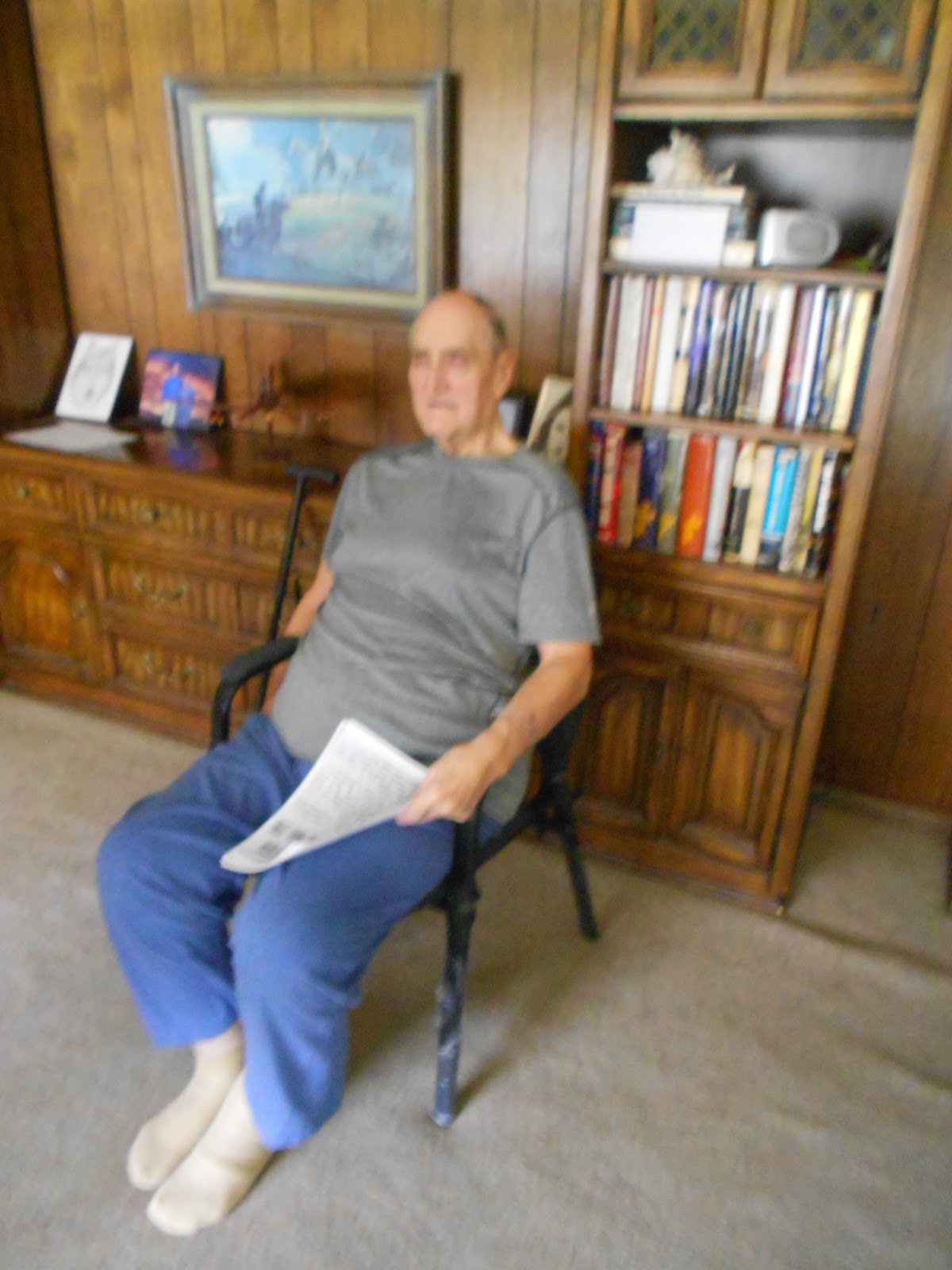
Fred Baker, 88, at his Ogden home in 2014.
In retrospect, Baker said the only real deficiency with the Ogden Temple's functionality was in that the fact it generally took longer for women than men to dress for endowment sessions was not figured into the design.
In its early years, endowment patrons did not assemble in the temple's chapel first --- they went straight to the endowment rooms. So, some benches were added outside the endowment rooms to help rectify that shortcoming.
Alvin R. Allred was the original Ogden Temple's first male proxy for a baptism on Feb. 3, 1972. Naomi Wall was the first female baptism proxy. Lowell Knight performed the first baptisms and Gerald C. Naylor was the confirming priesthood holder.
Temple workers were trained during February of 1972.
On March 4, 1972, the first endowment work was done at 9 a.m. That session included 22 brethren and 24 sisters.
In September of 1972, during a routine summer closing extra lockers for both men and women -- patrons and workers -- were added to keep up with unexpected demand.
At the same time, grass was removed north of the Tabernacle and asphalt added to try and keep up with peak parking demand.
The operate the temple initially, there were: 251 ordinance workers, 112 receptionists, 26 buildings and grounds staff; and 13 laundry employees.
The Ogden Temple had also boasted escalators for many years, until their upkeep and grease on white attire equaled their removal.
The Ogden Temple was also the site of many miracles over the years.
For example, these sample stories about the Ogden Temple are contained in the Church History Library Archives:
-One woman, LaVon T. Rees performed initiatory work one morning in the Ogden Temple in its early years. She was asked by workers if she would also do an endowment session, but had not yet taken her morning's medication and had also scheduled a golf game with a friend. So, she went to change clothes. In the dressing room she heard a woman sobbing, but there was no one in sight, or in the dressing room but her.
So, she felt impressed to get her temple clothes back on and do that endowment session. She began shaking and sobbing too, but as she got dressed, a yellow light seemed to come up from the floor and envelop her, warm her and comfort her.
As the session started, she saw the last name of the person another woman was proxy for and it was the same last name as her proxy name. She felt the woman she went through for desperately wanted her work done at the same time as another relative.
-A 15-year-old boy from Boise, Idaho, came to the Ogden Temple to perform baptisms for the dead. He had a restless night's sleep the evening prior and said he saw the name "John" appear as if on some sort screen before his eyes.
As he got into the front, he was the name "John" on the temple's display screen appear and felt comforted that this person was relying on him to do his work.
-In still another miraculous tale, Emeron Wall, a confirmation recorded at the Ogden Temple, seemed to suddenly go into a trance, while checking off names. He did not respond to anyone's voice.
When another temple worker touched him on the shoulder, he finally reacted and said he was OK. He said he saw a vision before his desk, of a beautiful women dressed in all white hovering above the ground. "Brother Wall, they had missed me," she said.
Brother Wall double checked his list and indeed one woman's name was not checked off.
Undoubtedly many such unrecorded miracles happened daily in the temple.
Another shortcoming to the Ogden Temple was itslow rate of attracting weddings. The unusual look of the outside of the temple, the lack of photogenic grounds and a dilapidated downtown Ogden likely all contributed to that weakness.
Still, the original Ogden Temple also lacked a wedding waiting room, something the new temple does have.
On February 17, 2011,
the Church announced that the Ogden Utah Temple block would undergo a complete
overhaul.
That meant short of a temple that had been destroyed by fire or mother nature, the Ogden Temple would be the first temple to be virtually totally rebuilt for other reasons.
This overhaul also meant that the historic Miles Goodyear Cabin -- the oldest building in Utah -- and the Daughters of the Utah Pioneers building both needed to be moved off Tabernacle Square, to a site a few blocks west.
Why
the original Ogden Temple need to be renovated at all?
It was an existing temple that had become somewhat outdated,”
according to Elder William R. Walker of the Quorums of the Seventy and
executive director of the LDS Church's Temple Department.
Regarding the decision to
redo the Ogden Temple, Elder Walker also said in a telephone conversation, “The First Presidency decided
to do it.”
He also said the temple
needed a lot of work and so a superficial remodel soon became turned into a full-fledged
rebuild project.
Also,
perhaps because of a combination of the downtown location and its space age
design, the Ogden Utah Temple also never attracted a substantial number of
weddings, like other Utah temples did.
It
is hoped this temple will do so.
Sadly, the reason for
timing of the tear down of the Ogden Temple was just a few months after Emil
Fetzer, the architect had died.
That was the church’s plan to do so all along,
independent of anything else – including the completion of the Brigham City
Temple first. Once its architect was gone, so was the temple. The Brethren made this decision to tear down the Ogden Temple -- once Fetzer had passed on -- some six years earlier in about 2005, according to Baker.
The
last operating day of the original Ogden Temple was Saturday, April 2, 2011.
Renovation
of the temple was supposed to last just 18 months to two years, but the project
required three years and about three months.
Much
of the 16-month delay came from underground parking construction that had to
deal with a large underground water problem.
The
former head groundskeeper of the original Ogden Temple and others, like veteran
subcontractors, who helped build the Original Ogden Temple, had warned the
Church and the contractor of that underground water problem, but neither would
listen or take that problem seriously.
(So, the morale here is not that mistakes are not made by church members/leaders, but that the miracle is that notwithstanding such mistakes, the Lord's work still manages to go forward.)
It
was only when the underground parking construction hit high gear that the underground water problem was acknowledged, and months of delays were faced.
In
addition, Elder Walker said “it was a more complicated project than originally
thought,” to redo the Ogden Temple.
Like
most any home remodeling project, he said it became more complicated and
lengthy that originally hoped for.
The
revamped temple does feature the same Angel Moroni statue that was there before,
refurbished and returned. It also still includes six ordinance rooms, same as
before, though some are smaller in size.
The only portion of the original Ogden Temple left intact are the cornerstone and time capsule. Those were disturbed as little as possible.
(The cornerstone of the Ogden Temple's time capsule is a copper sealed box that is 31 X 24 X 8 inches in size. It includes photographs of LDS Church leaders at the time and also of area stake presidents. In addition, it includes a picture of the U.S. President, Richard M. Nixon, as well as newspapers and other historical items of the era.)
It was not any seismic deficiencies that meant the Ogden Temple had to be rebuilt. Sure it was re-built with strong codes in mind, but if the Ogden Temple was so deficit in earthquake readiness, then how can anyone explain the far greater such seismic faults in Utah's historic temples -- Salt Lake, Logan, Manti and St. George?
Elder
Walker said the brethren don’t like throwing out dollar figures these days, so
he declined to provide any dollar costs.
And, given the scope of the old Ogden Temple
being so outdated and needing remodeling, it is likely only a
matter of a few years before its sister, the same-aged Provo Temple, receives a
major makeover too.
The interior of the rebuilt Ogden Temple is up several notches in fanciness. Instead of carpet, drapes and white walls. The redone temple boasts marble floors, stained glass and more elaborate light fixtures throughout.
The renovation also included energy-saving heating and plumbing systems, underground parking and a complete relandscaping in the temple block -- with a large reflecting pond on the temple's west side.
The temple also now includes two entrances, east and west side.
In addition, from an architectural and art deco style, the new Ogden Temple parallels parts of the design of some of the Ogden City's other historic buildings -- like the old Egyptian Theatre and the old City and County Building.
However, although the original cornerstone of the Ogden Temple was left intact, it was moved. Photographs of the first Ogden Temple show the dedication plaque and cornerstone on the northeast corner.
The revamped Ogden Temple has the plaque and cornerstone on the southeast corner.
Note too that the plaque on the new Ogden Temple is not the original one. A comparison of the two shows the same exact language, but spaced out differently. The new plaque is also much higher off the ground than the original.
The redone Ogden Temple held a public open house from Aug. 1 to Sept. 6, 2014. More than 550,000 people toured the temple during those dates.
A cultural celebration, featuring music and dance by
young church members, was also held on Sept. 20,
2014.
The temple was then re-dedicated in three different sessions on Sunday, Sept. 21, 2014.
The re-dedication also included recent parallel work done to the Ogden Tabernacle. That structure had its seating redone, some corner seating on the southwest end removed and other improvements.
The Ogden Tabernacle during its construction phase and with the steeple removed for good.
(However, the Tabernacle's steeple was removed permanently, so as not to compete with the Temple's steeple.)
It re-opened for temple work on Tuesday, Sept. 23, 2014. The first few days were said to be somewhat noisy and chaotic, as all new temple workers were manning their sites.
President Parley Baldwin of the Ogden Temple Presidency said at the re-dedication's second session that it was a "magnificent structure" and an "iconic temple."
Elder Holland stressed that the revamped temple is "the centerpiece of Ogden again."
This time around, the Ogden Temple serves 76 stakes of the church. The temple also has about 2,000 workers, as compared to about 1,400 for the original temple.
The original Ogden Temple was simply a landmark in LDS Church
temples. Its revolutionary plan exploded a boom for vicarious work for the
dead, that continued in future temples.
It was the first temple in the U.S. to feature
a film for endowment work, instead of the room-to-room company plan.
At 112,232-square feet, the new Ogden Temple is smaller than the original 115,000-square feet it once had. The temple sits on a 9.96 acre site, between 21st and 22nd Streets -- just west of Washington Boulevard, at 350 22nd Street.
This temple will serve more than 250,000 church members in northern Utah and portions of Western Wyoming.
What does Fred Baker think of the new Ogden Temple?
"It is wonderful, a fantastic building. It is gorgeous," he said.
Is he disappointing at the temple having to be reconstructed?
No. "The Brethren can do what they want," he said, stressing he supports their decisions.
He admits a "re-dedication" may not be an accurate word, given the scope of the temple's almost entire rebuilding, though.
The Ogden Standard-Examiner also reported on Sept. 27, 2014, after the temple had only been open four days, that "Ogden Temple filled with brides, grooms and sealings."
That was reported to be because many like the new look of the temple.
--Additional History of the Ogden Tabernacle and Tabernacle Square:
The
lengthy
history of Ogden’s Tabernacle Square reveals a potpourri of events, even
changes in ownership and failed dreams for some never-materialized projects.
-The original Ogden Pioneer Tabernacle, on the southeast corner of
the block, was began in 1855 and finally opened on Oct. 10, 1869, seating 1,250
people.
-However, soon after the railroad came to Ogden, work began on a new, larger
tabernacle and the old one was to be a concert hall. The sandstone foundation
actually reached a height of 4 feet before such plans were completely
abandoned, for a lack of funds.
(The leftover blocks were sold or given to nearby property
owners and their use was visible in the foundation or steps of some downtown
Ogden homes.)
-In the early 1890s, the LDS Church actually gave Ogden City the deed to the
property that is now Tabernacle Square.
A report in the Standard on Dec. 20, 1893 stated: “The city gives
it up. City Council gives back the Tabernacle Square to the church.”
-Also, in 1890, classes for Weber Academy students (forerunner to WSU) were
held in the Pioneer Tabernacle.
-Next, the Pioneer Tabernacle was completely remodeled in 1896 at a cost of
$15,000. A county-wide “Tabernacle Fair” helped raise the funds needed.
-There must have still been plenty of open space available, because “Football
on the Tabernacle Square,” was a May 2, 1897 headline in the Standard-Examiner.
The Gordon Stake and Weber Stake boys teams played for the pennant.
A week later, the May 9 Standard reported a baseball game being
held on Tabernacle Square, with the YMCA beating the Quincy Schools by a score
of 11-6.
-In 1908, a roadway was
planned to go through the middle of the Tabernacle Block and then lots could be
sold to finance a new Tabernacle. That never came to pass.
-Some fencing, flowers and shrubbery were first placed around the
Tabernacle in the fall of 1911.
-Despite the presence of sporting events on the Square, it wasn’t until the
spring of 1913 that the area was fully leveled and made into a park. Some 4,000
loads of dirt were brought in, as the ground level was still low. Grass was
planted and water lines for irrigation were installed.
The Tabernacle building itself was spruced up and an electric
blowing apparatus replaced the old water-powered one for the organ. More than
$13,000 in improvements were made.
-The April 28, 1913 Standard report mentioned each area stake
wanting its own building on the square and that a $100,000 tri-stake tabernacle
should be built at the center of the lot.
In fact, a Dec. 27, 1907 Standard article mentioned earlier plans
for a $200,000 new Tabernacle. None of that new construction happened.
(However, the Ogden 3rd Ward Chapel and amusement hall resided
on the southwest corner of the square for many years. In addition, the Relief
Building, now DUP Museum, resided on Tabernacle Choir for many decades, as did
the Miles Goodyear Cabin, with both now moved to 2100 Lincoln Avenue.)
-The original Ogden Tabernacle was a busy place and often, as
early as the 1920s, overflow church members had to go to the nearby Relief
Society Building to be seated.
-The next proposal for Tabernacle Square was outlined in the March 11, 1925
Standard, where Weber College wanted to create a first-class 440-yard running
track, plus goal posts, bleachers and a football field on the interior. (That
proposal never happened either.)
Elder Harold B. Lee finally broke ground on July 24, 1953 for a new Tabernacle
on Ogden’s Temple Square. The $723.000 building was dedicated on Feb. 12, 1956
by President David O. McKay.
-Ogden used to have its own, separate “Tabernacle Choir” for many
years too.
-SOURCES: Recorded/transcribed of interviews with Fred A. Baker on Sept. 8, 2014; other interviews with Fred A. Baker by the Church History Department; Articles in the Church Archives; Ensign Magazine Archives; Ogden Standard-Examiner archives; telephone interview with Elder William R. Walker; other personal interviews.
OTHER SOURCE: Ensign Magazine, January 1972.
-Note 1: Fred A. Baker passed away on December 10, 2015.
-NOTE 2: The author of this blog, Lynn Arave, co-wrote the official history of the Ogden Temple for the LDS Church, printed in 2014 and distributed exclusively to only a select group of LDS Church members.