Showing posts with label Weber County. Show all posts

Thursday, December 8, 2016

'Epidemic of Runaway Couples' in 1907 Ogden


By Lynn Arave

"Epidemic of Runaway Couples: Six young people from Salt Lake married; They like Ogden's way of doing things -- Surprise for the folks at home" was a June 24, 1907 headline in the Ogden Standard-Examiner.
The article mentioned how Ogden's pastors must be more accommodating than Salt Lake City's and hence why so many young couples were eloping some 36 miles north to Ogden fo
r a quick and less-questions-asked marriage.
The story stated that "the number of runway couples that come from Zion to be married in Ogden is steadily on the increase."
The also stated that two "supposedly confirmed bachelors, widely known to the businessmen of Salt Lake" traveled to the Hermitage in Ogden Canyon for their honeymoon, as they ended "their state of single blessedness."
"Salt Lake Girls run away to get married in Ogden" was a June 21, 1922 headline in the Standard-Examiner, and so this trend of runaway couples coming to Ogden for a quick marriage continued, at least for more than a decade.


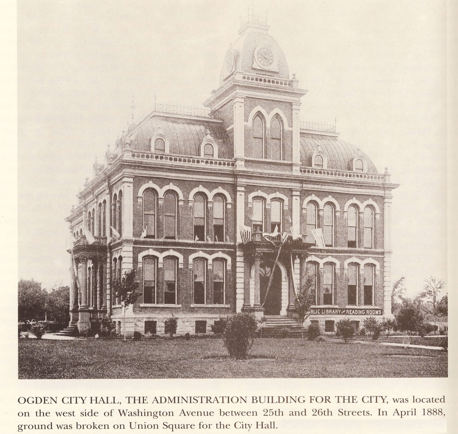
                                 The old Ogden City Hall.

Wednesday, March 30, 2016

From Muskrat Springs to Hooperville to Hooper


By Lynn Arave

Mention “Muskrat Springs” today and you’re likely to only cause bewilderment, as that title for today’s Hooper City was replaced more than a century ago.
Notwithstanding, there’s still a somewhat obscure pioneer monument to be found to that unusual moniker and even a ward of the LDS Church in town titled that.
Hooper was an early herd ground for pioneers. A fresh water source for area became known as Muskrat springs, presumably, because some of those critters were originally found there. The springs formed a large pond of water in the 19th Century. There were several other springs in southwest Weber County, but this was the most famous.
It was 1853 when William H. Hooper built a herd house in the area. Other settlers followed and by 1869, there were 22 families living in Hooper.
The Muskrat Springs name was popular enough that resident John Thompson wrote a song titled “The Muskrat Springs” in 1869. It was even sung more than five decades later in the summer of 1927 during a city pioneer celebration.


A Deseret News correspondent, known only as “G.C.L.” wrote this on Dec. 14, 1870:
“I was particularly pleased with the appearance of the settlement formerly known as “Muskrat Springs” but lately renamed in honor of our respected delegate Hooper city. It is situated on the Weber range midway between the Weber River and Kaysville and near the shore of the lake. It is a thrifty and well organized young settlement containing a number of good frame houses. The soil there is of a warm sandy nature and well adapted to fruit growing and the settlement will without doubt in a few years become one of the best in the territory. I have visited nearly all parts of the territory and as a suitable place for starting a new farm, I consider it the most desirable locality I have yet seen. The canal by which the water is conveyed to it is to be enlarged the coming winter and much more land will then be brought under cultivation.”
The name “Hooperville” for the community was prevalent from the 1880s until the early 1900s. “Fair at Hooperville was an Aug. 26, 1890 headline in the Ogden Standard-Examiner. But “Hooper” as a name took over for good in the 20th Century.
Hooper’s original boundaries went far south into Davis County, including part of today’s Syracuse City. It also went east into today’s Roy City and was for decades the only notable Weber County settlement southwest of Ogden.
Incorporation of Hooper City finally took place on Nov. 30, 2000.


-The Muskrat Springs monument is found near where the original springs was. That’s approximately at today’s 5300 South (that’s “Pingree Lane” to veteran Hooperites) and 5550 West. This metal marker is also near today’s Hooper Canal and was dedicated on Nov. 7, 1977 by Daughters of Utah Pioneers. 

(-Originally published in the Ogden Standard-Examiner on March 28, 2016.)

Thursday, December 3, 2015

Motor Migrants were a big problem in 1927 Weber County

                    -From a post card in D. Boyd Crawford's collection.


"MOTOR MIGRANTS latest problem on public hands: Weber County gets share" was a July 10, 1927 headline in the Ogden Standard-Examiner.
Even before the Great Depression struck, Weber County, Utah, had a significant amount of migrant people in cars, begging for gas and food and seeking places to camp.
A Riverdale storeowner reported in that story that up to 20 automobiles containing families had camped at night in farming areas near there in the past 6 weeks. Once these people earned enough money, or were handed enough funds, they moved on.
These so-called "Tramp Tourists" were all over the nation in that era.
Murray K. Jacobs of Riverdale reported that he talked to one Tramp Tourist, a mother of five children, who told him she'd been on the road for four years without a home.
These vagrants often begged for gas at rural service stations. In larger cities, gasoline theft was becoming an increasing criminal activity.
Some youth tourist tramps were also encountered, whose goal was to beg or buy a gallon of gas a day and let that take them that much further down the highway.


-NOTE: The author, Lynn Arave, is available to speak to groups, clubs, classes or other organizations about Utah history at no charge. He can be contacted by email at: lynnarave@comcast.net

1916: When Ogden, Utah had big plans for its own zoo


              An elephant at Salt Lake's Hogle Zoo in the late 1980s.


TODAY about the only zoos in Utah are in Salt Lake City and Logan.
The largest zoo of all and by far is Salt Lake's Hogle Zoo.
Logan boasts a much more moderate-sized Willow Park Zoo on its west side.
However, Ogden City had plans and hopes for its own zoo back in the late 1910s.
According to the Ogden Standard-Examiner of Oct. 12, 1916, Weber County Commissioners had hoped to have a small zoo going by 1919 in Glenwood Park.
Unlike Salt Lake, the Ogden zoo would have had more domesticated wild animals housed there, "to the extent they will not be a danger to have about," the story stated.
Bears, guinea pigs, rabbits, pigeons and other birds would have begun the initial collection of animals.
As far as can be determined, this original Ogden zoo plan was never implemented.
--Ogden DID HAVE a small zoo in the 1950s inside Lorin Farr Park. There were at the least some monkeys there, but that was gone by the 1960s and since then Ogden has lacked any kind of a zoo.


-

Thursday, August 6, 2015

Ogden’s old summer swimming holes

ALMOST a century ago, in 1918, the most popular place to swim and cool off in the summer was Jones’ Grove, at the back of Lorin Farr Park.
“Believe me your swimming pool in Ogden River is a pleasure and a joy after completing the dusty trip across the desert from California,” William E. Smith, a tourist, wrote in a letter to the editor in the Aug. 16, 1918 Standard-Examiner.
Smith’s letter continued: “It felt like the first oasis after a long trek and the whole family wallowed in it for an hour or more. Ogden knows how to extend the good hand of welcome to its vagabond auto visitors, and will be known all along the road for this practical hospitality.”
Smith’s only suggestion was that Ogden City add showers to its bath houses there. Later, in the spring of 1919, that feat was accomplished with a contract of $810.
However, not all was picture perfect for Jones’ Grove. “Hoodlums among women at swimming pool” was a June 28, 1919 Standard headline.”The complaints state that large boys have been using profanity in the vicinity of the pools and making threats to keep tourists away from the water,” the story stated.
The Ogden Publicity Bureau was already providing complimentary bathing suits for tourists in the auto camping park. Now, the police were instructed to rid the park of such hoodlums.
The Standard of July 22, 1919 reported that Ogden City had constructed a $4,650 children’s swimming pool on the grounds of Washington Park, which adjoined the playground of South Washington School.
So popular was this pool, that firm hours of use were immediately established: boys could swim from 1-4 p.m.; girls from 4-7 p.m.; and adults from 7-10 p.m.
-“’Ol swimmin’ hole made by youngsters near Ogden River Bridge always full” was a July 23, 1922 Standard headline.
Despite some artificial, cement pools in Weber County, some kids – especially those on the north side of town -- preferred the closer, open waters. They created a dam and made a 5-foot-deep water hole. There was a shallow are for young kids.
However, swimming attire was limited. The Standard story reported most swam in underwear and that one kid had improvised a swimming suit out of a gunny sack.
“At most any time a visitor my see a water circus. The kids have diving and swimming contests and stunt work and then divide off for a wild splash battle which lasts until one side gives up and the defeated members crawl to the banks to recuperate. The kids of the north end wouldn’t trade their pool for the best of the artificial kind. They made it themselves and are proud of it,” The Standard reported.
-Five years later, there was a problem with swimming in the Weber River. “Nude bathers given lecture. Sheriff’s Office makes roundups at old swimmin’ hole,” the Standard of July 11, 1927 reported.
“Small boys who caper in the waters of an old swimming pool in the Weber River, near the viaduct, but scorn to be handicapped by suits, were given attention today by the Sheriff’s Department,” the story stated.
Motorists over the viaduct had been complaining of the nudity. The boys were given a stiff lecture and promised to wear swimming attire in the future.
-There were also occasional accidents in the swimming river holes. A 17-year-old boy from Idaho drowned in the Weber River, near west 28th Street, on Aug. 10, 1919, in 10 feet of water. There were an estimated nearly 100 deaths in this “Caving Bank” portion of the Weber River, from 1879-1919, because of a strong undercurrent. Three or four deaths happened some summers there.
A Standard editorial asked for lowering the depth of the water there.

 (-Originally published on-line and in print in the Ogden Standard-Examiner on Aug. 6-7, 2015, by Lynn Arave.)


-NOTE: The author, Lynn Arave, is available to speak to groups, clubs, classes or other organizations about Utah history at no charge. He can be contacted by email at: lynnarave@comcast.net


Thursday, April 23, 2015

When I-15 almost took a different path in Davis and Weber counties

                            Looking down on a section of Highway 89 in Layton in 2015.


By Lynn Arave

Imagine a mountain hugging Interstate-15 in North Davis County and Southern Weber County.
I-15 from Farmington to Ogden almost went a different route – Highway 89, instead of today’s western route, near Highway 91.
The Ogden Chamber of Commerce had pushed hard for the Highway 89 freeway option. After all, that offered the most direct access to Ogden City and Weber State College.
However, an independent study revealed that it would be far more costly to build I-15 along the Highway 89 corridor. Also, the western route option offered more direct access to the military installations in the Top of Utah.
And, once a Highway 89 aligned freeway reached Ogden, where would it go northward from there, without impacting large sections of homes and businesses?
According to Glen M. Leonard in his book, “A History of Davis County,” The Federal Interstate Highway Act of 1956 expanded federal subsidies for major state highways and meant Washington paid 95 percent of the costs of such superhighways. So, it wasn’t “if” freeways would be built in Utah, it was just “when.”
Leonard’s book states that increased traffic between Salt Lake City and Ogden is why the Utah State Road Commission chose a six-mile section in south Davis County to be Utah's first highway built to interstate standards.
“In a ceremony in North Salt Lake in January 1958, Governor George D. Clyde launched the project by driving a bulldozer into Amasa Howard's ninety-year-old dairy barn to clear a route for the new $7.3-million segment,” Leonard wrote. “Utah's first section of six-lane divided interstate highway reached north to Pages Lane and was completed in 1962.”
However, original plans did not include any interchanges between Farmington and Bountiful. Centerville had to lobby to eventually gain its own freeway access.
Bids for constructing I-15 in the Ogden area opened in 1963, split into several segments.
After three years work, I-15 from south Layton to Ogden opened on Nov. 23, 1966. A huge advantage with this section meant that Main Street (Highway 91) would no longer be so congested with commuters during shift changes at Hill Air Force Base.

                              I-15 in Layton.

The I-15 route north of Layton often followed the abandoned Bamberger Railroad route.
On Dec. 12, 1976, the section of I-15 from the Box Elder-Weber County line to Perry was completed after more than four years of work. This meant I-15 was now continuous from Layton to southern Box Elder County.
However, the Lagoon to Layton section of the interstate was the last section finished in the Ogden area.
The widening and resurfacing of the existing section of Highway 91 from Layton to Lagoon was not open until 1977 through a $10 million project. This finally meant uninterrupted freeway travel existed between Juab County on the south and Box Elder County on the north. Future projects would expand the freeway both north and south.
Leonard also noted that I-15 in Davis County produced a housing boom too.
“The communities along the freeway's route rightly envisioned a new incentive for growth,” Leonard wrote. “Interstate 15 made the greatest difference in the Centerville, Farmington, and Kaysville areas, which had lagged behind other parts of the county because of their distance from both Ogden and Salt Lake City.”
He continued: “Also, as in the Syracuse region, a stable agricultural population existed in the central core. Small subdivisions began appearing in these central cities about the time the interstate began reaching into the county from the south. Suburban sprawl brought the first, small subdivision to Syracuse in that same decade.”
Utahns probably take I-15 for granted today, but inter-city travel in the Top of Utah wasn’t nearly as quick or convenient before the freeway came along.

(-Originally published on-line and in print in the Ogden Standard-Examiner, by Lynn Arave, on April 23-24, 2015.)


-NOTE: The author, Lynn Arave, is available to speak to groups, clubs, classes or other organizations about Utah history at no charge. He can be contacted by email at: lynnarave@comcast.net


Thursday, April 9, 2015

Ogden's Waterfall Canyon: Deadly scenic beauty and more


            The 125-foot falls, not so impressive in the spring of 2015, thanks to a drought.

By Lynn Arave

OGDEN'S Waterfall Canyon is as deadly as it is beautiful.
Over the decades, more people have likely been killed, or injured there than any other canyon in the Ogden area.
There’s the infamous triple tragedy of Dec. 26, 1962, when three youngsters – all under age 10 – fell off rock ledges just south of the falls and plunged to their deaths.

But there were other accidents there too.
-“Boy, 14, plunges from top of Waterfall Canyon” was a May 16, 1941 headline in the Standard-Examiner.
Leland Oxnam, a student from Washington School, was climbing on rocks directly above the falls, when he slipped and was killed. He was with two other classmates at the time.

                           More a cascade than waterfall in 2015.

-Kimball Vaughn, 25, of Ogden, died in an Ogden hospital on April 24, 1939, from injuries sustained two days prior from a 50-foot fall in Waterfall Canyon.

       The rocks around and above the waterfall are a dangerous magnet to amateur climbers.

-Andrew Cooper, 17, of Ogden, was found dead in the water at the base of the waterfall on April 23, 1974, after a fall from a top the rocks. He was alone at the time.

 There were also lucky survivors from accidents too:

-On Aug. 6, 1883, some boys found a strange metal capsule inside the canyon. It turned out to be an explosive device and went off when one of the boys shook it. His hands were mutilated and he lost two fingers. The other boys suffered face and head wounds.


-David Melvin, 16, fell 30 feet off a cliff in the canyon in April of 1895. He somehow was only bruised.

-“Eludes a rattlesnake, but breaks a leg” was a Aug. 13, 1910 headline in the Salt Lake Herald. “Preferring to take the chance of jumping from a thirty-foot cliff in Waterfall Canyon, than being bitten by a rattlesnake, Fred Craner, 19, today, suffered a severe fracture of his left leg,” the story reported.
The man said the rattler was coiled and ready to strike behind him when he chose leaping to a pile of boulders below instead.

     Now you can no longer legally climb above the waterfall, with a posted no trespassing sign and a steel cable in place to block the way of the traditional route, a draw southeast of the waterfall..


-“Binks ‘comes back’ after fall to death” was a Nov. 14, 1910 headline in the Salt Lake Herald. William Sawyer of Ogden claimed his bull terrier, “Brinks,” had fallen some 200 feet off a cliff while hunting  in Waterfall Canyon. Sawyer said it took hours to climb down to where the mangled animal was and he buried it there, as best he could.
Two weeks later, the dog somehow amazingly came through his family’s gate, collapsing lean and hungry on the doorstep. The family nursed the dog back to health, but could not find a single broken bone. He ate enormous amounts of food, but the family and neighborhood considered it a miracle.

                      The trail at the mouth of Ogden's Waterfall Canyon.


-"Climber rescued after 23 hours on death perch" was an Aug. 3, 1925 newspaper headline. Louis Buswell, 28, became stranded on the cliffs near the waterfall and rescuers needed 300 feet of rope to haul him off a cliff face.

                          Hikers enjoy the limited waterfall flow in the spring of 2015. 


-On May 28, 1958, Larry Smith, 14, fell more almost 100 feet from the rocks around the falls and was severely injured. 
He was climbing the face of the falls freehand. He was near the falls about three fourths of the way up when he waved to us girls and then fell.
He and some friends had skipped school that day with parents permission except, Larry.
Three friends ran to the nearest place which was the St Benedict hospital. They called for help. The friends all hiked back most of the way and rescuers it from there. They took him to the Dee hospital. He was there a long  long time. He was paralyzed for months. After years, he learned to walk with a crutch dragging his feet. He now owns an archery place south of Salt Lake.

 (-Originally published on-line and in print, April 9-10. 20-15 in the Ogden Standard-Examiner, by Lynn Arave.)


-NOTE: The author, Lynn Arave, is available to speak to groups, clubs, classes or other organizations about Utah history at no charge. He can be contacted by email at: lynnarave@comcast.net

Thursday, February 5, 2015

1890s: When living west of the tracks in Weber County was a pain


     Aerial photo showing the vast width of the Ogden railyards, circa 1950s, looking northward.


 “CROSSING the tracks” was a big deal in 1890 West Ogden.
“Be careful how you drive, Gentlemen from out of town,” the Standard-Examiner of Dec. 16, 1890 reported.
People from Hooper, West Weber, Kanesville and Wilson all used 24th Street to enter Ogden and the large train yard was considered a “blockade.”


The Standard reported that some 40 teams of horses and wagons had to wait for at least 30 minutes that day prior before trains moved out of the way.
“It is a common occurrence,” C.C. Wilson of Kanesville said of tracks blocking 24th Street.
An estimated population of 2,500 people lived west of Ogden in 1890 and the word “viaduct” was now viewed as the only future solution.
(However, such a viaduct on 24th Street would not open until 1910, two decades later.)
-Speaking of roads, “State aroused as ‘Death Road’ claims two more lives” was a Dec. 8, 1947 headline in the Salt Lake Telegram.
The strip of State Highway 91 in Davis County, between North Salt Lake and the north end of Farmington , had claimed 28 people that year in traffic accidents, far more fatalities than anywhere else in the state.
“Strip of Death” was another nickname for that stretch of highway, with speed limits of up to 50 mph.
Highway officials planned to study the section of busy road and make safety improvements. However, if would not be for almost 20 years, until I-15 was constructed in that area, that the road became much safer for motorists.
In other historical tidbits:
-“Gorilla at large” was a Sept. 16, 1887 headline in the Standard. A gorilla from a circus at Union Square had gotten loose just after dark and disappeared.
Men were reported running around with torches, peering into yards and over fences, trying to find the animal at a late hour.
Two days later, on Sept. 18, the Standard reported that the gorilla had eventually been found, happily eating at a bakery on the lower side of town.
-“Law may pursue the Ogden girl with the hobble skirt” was a Jan.  17, 1914 Standard headline.
An Ogden Judge, V.C. Gunnell of the juvenile court, had started a campaign against girls and young women wearing hobble skirts.
"It is a common thing " the Judge said, "to see young girls trying to get over ice or through snow and mud where so ridiculously hobbled as to make them objects of pity as well as ridiculous."
He had noticed nearly every day, while going to and from his home, school girls trying to get to the high school from Washington Avenue, with their legs dangerously and evidently painfully bound and made nearly useless by tight skirts.
The Judge favored shorter, more nicely fitting dresses.

 (-Originally published on-line and in print on Feb. 5-6, 2015 in the Ogden Standard-Examiner, by Lynn Arave.)


-NOTE: The author, Lynn Arave, is available to speak to groups, clubs, classes or other organizations about Utah history at no charge. He can be contacted by email at: lynnarave@comcast.net  

-

Friday, May 23, 2014

Dreams of lofty mountain roads never built in northern Utah

                       The rugged road to Willard Basin was constructed by the CCC in the 1930s.


By Lynn Arave

THIS is a tale of mountain roads dreamed of, but never built.
Ogden area residents were very excited about the advent of the automobile. In fact, they had dreams in the 1910s of constructing auto roads to the top of prominent local mountain peaks.
The first such dream appeared in the Standard-Examiner on June 25, 1912:
“Why not build an automobile driveway to Lewis Peak or one of the other high mountains east of Ogden, so that even those not stout of heart and vigor of limb can reach the heights, see the grandeur of the mighty architectural work of Omnipotence and hitch wagons to the stars,” the report stated.
That way, the story stated, even Postmaster Lewis Shurtliff, who was one of the first recorded to climb Lewis Peak, some 60 years earlier, could “go back in fancy to the days of long ago while a six-cylinder machine under low gear carried him up to the base of the peak in the clouds.”
Ben Lomond Peak, almost a year later, was the next peak mentioned as needing an auto road.
“From Ogden to a peak above the clouds” was the May 20, 1913 story in the Standard.
“To build and improve the road from Ogden to Ben Lomond peak by way of Liberty is a proposition that is receiving the support of a number of Ogden people, among whom is Attorney D.R. Roberts.”
The report stated that the road would have to be made from the backside, from Liberty, as cliffs on the Ogden side prevent a road from there.

                          Another view along the Willard Basin road.

“A road to that peak would attract autoists from all parts of the western country and no transcontinental tourist would pass by Ogden without making the visit to the point,” stated Roberts, who believed the road would be one of the most famous auto trips in America.
The report infers that there already was – in 1913 -- a road of sorts from Liberty (perhaps from today’s North Fork Park area) partway to the back of Ben Lomond.
Of course, neither the Lewis Peak, or the Ben Lomond road was ever built.
(The two stories didn’t mention the still existing “road” to Malan’s Peak and Malan’s Basin that went up Taylor Canyon, starting in 1892. This path was just wide enough for a horse and special small wagon.)
Salt Lakers were also infected with the same conquering spirit.
The Davis County Clipper reported on Oct. 17, 1913, that the Salt Lake City Commission had ordered a survey made of a possible mountain road.
This path would be made around the base of Ensign Peak and continue along the shoreline of Lake Bonneville to Mill Creek Canyon and eventually through the mountains to Morgan.
This report said city prisoners could do some of the construction and big landowners along the route had already agreed to provide legal access.
Some believed such a road would keep tourists in the Salt Lake area for days, weeks and months, instead of just hours.
This road never happened either, though today there is the “Scenic Backway” of Skyline Drive that goes from Farmington Canyon and along the mountain top to Bountiful (yet this dirt route lacks similar access to the Morgan side).

(-Originally published in the Ogden Standard-Examiner on May 23, 2014.)


                Looking down into Willard Basin from the west side. Note the roads below.


-NOTE: The author, Lynn Arave, is available to speak to groups, clubs, classes or other organizations about Utah history at no charge. He can be contacted by email at: lynnarave@comcast.net  


Friday, December 20, 2013

The first Christmas celebration in Utah?

Weber County's first Christmas observer also traveled up Weber Canyon and then from Peterson to "Ogden's Hole" in an expedition that began New Year's Day. He may have been near today's Trappers Loop Highway.                                                                                      Photo by Whitney Arave.


Who was the first white person (or persons) to celebrate Christmas in Weber County, if not all of Utah?
Was it:
A.  Miles Goodyear, in Ogden, 1845.
B.   Mormon settler James Brown and company, in Ogden, in 1847.
C.   John C. Fremont and/or Kit Carson in 1843.
D.  None of the above.
If you answered “D,” you would be correct.
Surprisingly, it was a mountain man and trapper, Osborne Russell, who celebrated the holiday, Dec. 25, first in Weber County in 1840.
Russell (1814-1892) was most famous as a political leader who later helped form the government of the State of Oregon.
  He kept a detailed journal of his nine years (1834-1843) in the Rocky Mountains and his account is a fascinating read, which predates John C. Fremont and Kit Carson’s visit in 1843 by almost 3 years.
He outlines his Christmas holiday as taking place near where the “Weaver” River (Weber River) empties into the Great Salt Lake. By that description, he most likely would have been in today's Hooper (or perhaps West Haven) for the holiday season.
 Russell spent the holidays in an Indian lodge, in the company of a French Man, his Native America wife and their child. In nearby accommodations were other Indians and children.
It was agreed on by the party to prepare a Christmas dinner …” Russell wrote in his journal.
He noted that his understanding of French and Indian language was helpful, as only three others knew English and that was a pretty sketchy proficiency.
At about 1 p.m., the group sat down to Christmas dinner, “in the lodge where I staid which was the most spacious being about 36 ft. in circumference at the base with a fire built in the center …” Russell wrote.
What did they eat?
   “The first dish that came on was a large tin pan 18 inches in diameter rounding full of Stewed Elk meat,” Russell wrote of the 1840 holiday feast.
The group had found a large group of elk, out west, by the lake, wintering in the thickets of wood and brush by the river.
“The next dish was similar to the first heaped up with boiled Deer meat (or as the whites would call it Venison a term not used in the Mountains),” Russell continued.
“ The 3d and 4th dishes were equal in size to the first containing a boiled flour pudding prepared with dried fruit accompanied by 4 quarts of sauce made of the juice of sour berries and sugar Then came the cakes followed by about six gallons of strong coffee already sweetened with tin cups and pans to drink out of large chips or pieces of Bark Supplying the places of plates,” Russell wrote in his journal.
He also explained that eating did not commence until the word was given by the landlady. Then, conversation was expected of all.
“The principal topic which was discussed was the political affairs of the Rocky Mountains The state of governments among the different tribes …” Russell wrote.
What about after dinner?
“Dinner being over the tobacco pipes were filled and lighted while the Squaws and children cleared away the remains of the feast to one side of the lodge where they held a Sociable tite a tite over the fragments. After the pipes were extinguished all agreed to have a frolic shooting at a mark which occupied the remainder of the day,” Russell ended his holiday account.
 He remained where he was until Jan. 1, 1841, at which time all the streams were iced over. So, he moved eastward.
 Russell wrote that he then followed the Weber River eastward and then when it forked, it went right into Weber Canyon.
“The route was very difficult and in many places difficult travelling over high points of rocks and around huge precipices on a trail just wide enough for a single horse to walk in …” Russell write of Weber Canyon.
 He likely camped in the Peterson area, where the snow was some 5 inches deep. It snowed another 8 inches that night. The next morning, he went north over rolling hills into Ogden’s Hole (today’s Ogden Valley), where the snow was 15 inches deep. He spotted a herd of 100 elk and shot one for food.
The next day, he returned to where he had spent Christmas and remained there for the rest of January.
There is much more to Russell’s early account of the Ogden area, including descriptions of Fremont and Antelope islands.

(Special thanks to Terry Bennett of Layton for suggesting this first Christmas holiday account).

Note: Russell’s journal accounts were left as they were written, abbreviations and grammar notwithstanding.
Also, the offensive word of today -- "squaw" -- was also not changed, but left as it was written ... for historical accuracy's sake and nothing else intended.

(-Written by Lynn Arave and originally published in the Ogden Standard-Examiner on Dec. 20, 2013.)

-NOTE: The author, Lynn Arave, is available to speak to groups, clubs, classes or other organizations about Utah history at no charge. He can be contacted by email at: lynnarave@comcast.net  


Tuesday, August 20, 2013

Hooper, Utah: Pioneer Settlement, from Muskrat Springs to Incorporation

                        Welcome sign from the Davis County side of Hooper.

HOOPER, Weber County, Utah, has been the brunt of many a joke over the years.
Hooper, correctly pronounced: "Hup-er," NOT "Hoop-er," was one of the key settlements in early Northern Utah.
For decades after the Mormon Pioneers settled in Utah, you went from Ogden west to Hooper and there was nothing in between.
All the other cities in between came later.
Fur trappers probably visited the Hooper area as early as 1826, but the first verifiable visit was by explorers John C. Fremont, Kit Carson and others on their way to the Great Salt Lake. 
In September 1843, Fremont and company passed down the Weber River in a boat, through what is now the Ogden Bay Bird Refuge and into the lake, en route to Fremont Island.
In pioneer days the area was known as Muskrat Springs, for an artesian well where the critters were plentiful. It was also used by Capt. William H. Hooper and others as part of the "Weber Herd Ground." Hooper had cattle there, and his herdsmen built Hooper's first house, a two-story abode, in 1854.
Today's community is named after Hooper, Utah's first delegate to Congress, though he probably only visited the area occasionally. Hooper was also the original director of ZCMI and later its second president, succeeding Brigham Young. 
(Many places around the Soda Springs, Idaho, area were also named after Mr. Hooper because he used that area for his summer home site.)
James Hale started Hooper's first business in 1863 when he built two dugouts on the shores of the Great Salt Lake and gathered salt to sell in evaporated sloughs (except when rising lake water forced him to temporarily move out).
By 1876 several settlers had moved in, most of whom have descendants who still live in Hooper - Belnap, Hull, Read, Parker and Cox. These new settlers petitioned to have many of the cattle moved out, so Hooper moved his cattle to the Skull Valley, west of Grantsville.
The area was subsequently known briefly as "Hooperville," until that name was shortened to Hooper.
Sugar cane and corn were Hooper's first crops. Alfalfa and fruit trees also soon became important crops.
By 1877, Hooper ranked second only to Ogden in land area and population (about 100 families) in the Weber-North Davis area.
Hooper became an incorporated city in Weber County on Nov. 30, 2000. Its boundaries technically go west across the Great Salt Lake and include Fremont Island.
Some of "Hooper" (as defined by tradition) includes a section in Davis County towards West Point City. However, all of that land will surely one day end up as part of West Point City, since no one else can annex it.

-(Expanded from a Deseret News article by Lynn Arave on May 3, 1989.)

-NOTE: The author, Lynn Arave, is available to speak to groups, clubs, classes or other organizations about Utah history at no charge. He can be contacted by email at: lynnarave@comcast.net  


Monday, August 19, 2013

Trapper's Loop -- The Old, the New and The Original

                          A lofty view looking south along U-167.

WHERE'S the original Trapper's Loop in Weber and Morgan counties, used by pre-1847 trappers and Native Americans?
It is not the lofty paved highway, U-167, that opened in September of 1989.
Neither is it the much lower elevation dirt road to the east that some hunters and area land owners still use.
According to William H. Terry, a late historian from Ogden, the original trail is now non-existent. 
The first loop was a Shoshone Indian trail that followed Hawkins Creek from the Ogden Valley side, went over the ridge and down into the Mountain Green area in Morgan Canyon. The trail followed water and food sources.
Terry told this to the Deseret News at age 84, in the spring of 1990. (It is Terry who wrote the words that are blazed on many area historical markers, such as the one at the top of North Ogden Divide, or at the Mountain Green rest stop along I-84.)
Terry said the "loop" description came about because travelers would loop back and forth the same way. He said Hawkins Creek is between the new paved Trapper's road and the old dirt road, so while neither of these two roads follows the original trail, the dirt road at least comes closest to the original path and is within a few hundred yards of Hawkins Creek at its summit outside Ogden Valley.
Soon after 1860, when the Ogden Valley was settled (it was called Ogden's Hole then), coal was hauled across the route, so at one time it was called the "Old Coal Road."


               A 1989 view of the dirt road along "Trapper's Loop," at the midway point.


Trapper's Loop was just a trail until the 1920s, when the first wagons were taken across it between the Ogden Valley to Mountain Green. Terry said he was part of a Works Progress Administration government survey for a new road in that area during the summer of 1934. However, the road he surveyed was never built, but the current dirt road was constructed years later, probably during the 1940s, in a somewhat different place.
The name Trapper's Loop, according to Terry, wasn't coined until 1968, probably as a result of some editorials in the Ogden Standard Examiner newspaper. Until that time, the route had usually been referred to as the Mountain Green-Huntsville trail or road.
                          The newest "Trapper's Loop road is curvy.

A timeline of Trapper's Loop travel:
Pre-1800s: Before the white man, Shoshone Indians started at Hawkins Creek, passed over the mountains and into Mountain Green to the Weber River.
1824: Trappers enter the region, and Peter Skene Ogden is believed to be the first to lead trappers over the trail a year later.
"Our coarse this day south over a hilly country for 10 miles when we again reached a new river but had nothing but some stone and gravel without any appearance of beaver . . . ," Ogden wrote in his diary.
1920s: The first wagons, as well as the Weber and Morgan county commissioners, travel the loop, referred to as the Mountain Green-Huntsville Road. It is envisioned as a major route between Weber and Morgan counties.
1934-1935: The first actual proposal to build a good Trapper's Loop road is presented to the Legislature. The government surveys the route.
1940s: The Trapper's Loop dirt road is built.
1968: An editorial in the Ogden Standand-Examiner is credited with coining the name "Trapper's Loop."
1989: On Sept. 23, the new Trapper's Loop (U-167) opens after $14 million, three years of actual construction and 54 years of proposals. The dirt Trapper's Loop road is turned over to Weber and Morgan counties for maintenance.
(Later, a direct access road to Snow Basin was added as a spur road off Trapper's Loop, in time for the 2002 Olympic Games.)
Why the new road?
--Ever wonder why it took about three years to pave and open the new Trapper's Loop Road, or why the existing dirt road wasn't used?
That's because it was built from scratch. The original dirt road, also named Trapper's Loop, was untouched.
Why wasn't the old Trapper's Loop road just paved over for the new road?
Lynn Zollinger, an engineer for the Utah Department of Transportation, said initial considerations included using the original Trapper's Loop road for a modern paved highway. However, several geologic factors changed that decision.
Zollinger said the dirt road travels over unstable soil and crosses several potential landslide areas. The original road also has far too steep a grade in the first two miles from the Huntsville side.
The new paved road, just west of the earlier road, is about 1.5 miles longer but has a more gentle grade, making it easier and safer for vehicles. 
The two Trapper's Loop roads are different in many ways, though they are perhaps within 600 yards of each other at their closest points and within a mile or so at their most distant. Consider these differences between the two:
Road conditions:
- The old road is made of extremely hard dirt and clay. It's barely wide enough for one vehicle and is also so rugged that it is only suitable for trucks, motorcycles or mountain bicycles.
- The new road is a modern, paved, three-lane highway, with a passing lane on each climbing side.
Elevation changes:
- Leaving the Ogden Valley, the old road starts out extremely steep and climbs 900 feet in the first four miles, but from there it drops dramatically and passes through numerous small unnamed hollows and canyons, far below the newer highway. This road offers only a few bird's-eye views of the area.
- The new road is only slightly higher at its apex as it climbs much more gradually to an approximately 6,000-foot-plus summit before dropping over the Mountain Green side. Thus, there's almost a never-ending view of the surrounding area and the Wasatch Mountain backdrop behind Mount Ogden.
Length:
- The old road is roughly eight miles long.
- The new road is 9.5 miles long.
Usage:
- The old road is rarely used, except by an occasional truck or horse, and offers solitude.
- The new road is used almost continually by sightseers and by Ogden Valley residents heading to Salt Lake City.
Age:
- The old dirt road has probably been around for almost 75 years.
- The new road was built from scratch, starting in 1986.

The Old roadway evokes pioneer spirit:
I found it next to impossible in the spring of 1990 to locate exactly where the original Trapper's Loop trail went. Also, since fences, livestock and private land are prevalent in the area, I chose to settle for traveling the Trapper's Loop dirt road on a mountain bike in order to get a feel for what the trappers and Indians might have felt and saw as they went through the same area. Here are my observations and thoughts:
On the Ogden Valley side, the original Trapper's Loop begins just east of the Jackson Fork Inn, about 600 yards east of the new highway. The beginning elevation is about 4,900 feet. Approximately 500 yards up the road, a metal gate makes it possible to close the road for bad weather.
The road is rough and the climb taxing for the first two miles, as it rises to 5,800 feet above sea level. Surprisingly, the old road is higher at this point than the new one, and there are some contrasting scenic views available here.
Heading on, it's almost all downhill through various hollows. The road crosses the Weber-Morgan county line just after the summit, though there are no signs.
The road crosses over four streams, and since there are no bridges, you have to ford your way across. One stream bed was dry, but high runoff could easily block this road. That at least shows this road hasn't lost all of its frontier flavor. . . .
Sometimes the road passes through desert sage, while at others it is lined by aspen and oak brush. The road has spectacular views, only exceeded by the new Trapper's Loop road, with its higher elevation and better lookout points. The new road can be seen in the distance several times along the way.
The old road travels through an area of mostly privately owned land. In fact, about a mile from the Mountain Green side it is posted with "No Trespassing" signs, so legally cannot be traversed completely.
Numerous side roads head off the main dirt road. Some probably cross private grazing land, but most appear to eventually intersect the new highway to the west.
Overall, the old road is probably more like the original trail used by Indians and trappers than the new highway, since the unpaved route travels through more canyon areas that likely offered water and better opportunities to hunt wildlife. Indians and trappers probably weren't concerned as much about the view or long-term safety from landslides as they were with simply getting across the area by the easiest way possible on foot or horse.
I crossed the original loop, too, knowing that much of what I saw was very much like what trappers and Indians would have seen. Also, I was no longer upset at the notion that a new Trapper's Loop road had to built. After all, the new highway does offer better scenic views of the area and the route is a much safer location for a modern highway.
But more importantly, the new route allowed the old dirt road to remain a rough, frontier-type trail more evocative of the pioneer spirit.
(-Expanded from a Deseret News article by Lynn Arave on May 17, 1990. He mountain biked all the dirt "Trapper's Loop" that was publicly accessible at the time.)


-NOTE: The author, Lynn Arave, is available to speak to groups, clubs, classes or other organizations about Utah history at no charge. He can be contacted by email at: lynnarave@comcast.net