
The heart of the Moki Dugway switchbacks.
Photo by Ray Boren in 2018.
WHAT the upper Angels Landing Trail in Zion National Park is to hiking (scariest and most unforgettable), the "Moki" (sometimes also spelled "Moqui" or "Mokee") Dugway is the equivalent to highway driving in Utah.
Often known in San Juan County, Utah as "White knuckle hill," this three-mile-long graded dirt road with an 11 percent grade is unique in the State Highway system, it being a segment of Highway 261, from Mexican Hat to Highway 95 (south of Bear's Ears) or a shortcut to Hite Crossing on Lake Powell.This road climbs 1,200 feet up a sandstone cliff face and has no guard rails. The road is also so camouflaged into the cliffs, that you have to almost be on the switchbacks to see them.
The road drops 750 feet in just 440 yards.
"Going up or down is an experience not soon forgotten," is how the San Juan Record newspaper described driving the Moki Dugway on July 24, 1985. The Dugway has become one of the area's spectacular attractions -- and the nearby Muley Point Overlook doubles the eye candy.

Approaching the cliff the Moki Dugway climbs up is almost invisible until you're driving on it!
Photo by Ray Boren in 2018.
Supposedly, the future Moki Dugway slope is where Ute Chief Posey, though wounded, somehow came down the steep mountain and eluded law officers in the 1920s, intent on capturing the Chief for the final Ute uprising.
According to the San Juan Record of July 13, 2005, the Dugway's original name was "Isabelle Hill," though no one seems to know why, or when it switched to "Moki." Why some variations of the name spell it "Moqui" or "Mokee" is also unknown, but the shortest spelling is the norm now by common usage.

Photo by Ray Boren.
The switchbacks begin at an elevation of 5,325 feet above sea level and top out at 6,525 feet.
The San Juan Record of July 1, 1998 proclaimed the road, "gives new thrills to the driving experiences of the southwest" ... and "provides access to an overlook on top that provides panoramic views of the area."How did this Dugway come to be?
The Texas Zinc Corporation began to build the Dugway and a total of 33 miles of road in 1955 from Utah Highway 95 south across Cedar Mesa to Mexican Hat, according to the San Juan Record of Jan. 7, 1965. Plagued by strikes, the road was finally complete in mid-1957 and it provided direct access from the high elevation mines down to a uranium mill at Mexican Hat.
The Dugway portion of the road alone cost $1 million (more than $9 million in 2020 dollar value).
The road was deeded over to the State of Utah in 1957 and officially opened as a state highway on Aug. 10, 1957. Yet, the other portions of U-261 were not paved until 1961-62.


(Texas Zinc Corp. was bought by Atlas Corporation in 1963 and the uranium mill at Mexican Hat closed in 1965.)
San Juan County asked the UDOT to pave the road several times over the decades, including in 1971, according to the San Juan Record on Jan. 21, 1971. However, that never happened and the road remains gravel today.
(To bypass
the Moki Dugway means drivers have to go along U-191 from Mexican Hat toward
Blanding and then turn left onto U-95 toward Hite. The difference in distance
is 30 extra miles without the Dugway, or about 37 minutes extra in travel time.)
Drivers going northwest out of Mexican Hat on U-261 see a high cliff in the distance and wonder where the road goes until the switchbacks come into view. It is likely motor home operators, big rig drivers and those afraid of heights who are unaware of the Dugway, surely question their sanity when they encounter the switchbacks going up or down.
Monument Valley High School held the "Moki Dugway Hill Climb," a three-mile footrace on Dec. 14, 1991. Newspapers only contain that one single reference to the race being held.
One Google review of the Moki Dugway describes it as an "incredibly scary gravel road like going down the side of the Grand Canyon." Another recommends that only those unafraid of heights drive it, while some others thought it was over-rated.
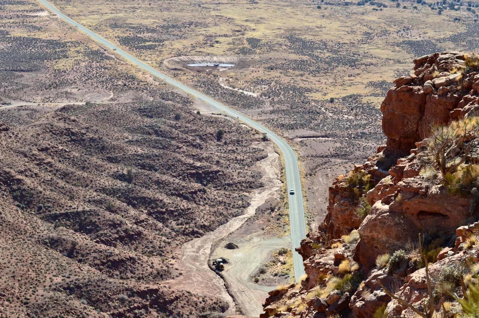
Photo by Ray Boren.
-"Skyway prospects delight San Juan" was a Dec. 29, 1968 headline in the Salt Lake Tribune. Reporter Carl E. Hayden stated that there was a plan to build a "sky railway" from the top of the Moki Dugway at Muley Point to Mexican Hat.
People would be shuttled from Mexican Hat and up the Dugway -- about 16 miles -- in buses and then be able to pay to ride a gravity powered cable car about 12 miles straight down as the bird flies to Mexican Hat.
This "would give tourists the breathtaking joy of ascending the Moki Dugway," according to the Tribune.
Of course, the skyway was never built and in today's era, with controversy over increased commercial access to the nearby Bear's Ears area, sacred to Native Americans, the development would probably never happen.

-Photo by Ravell Call.
AT LEAST 5 ACCIDENTS ON THE MOKI DUGWAY:
Yes, people have died on the Moki Dugway.
1. According to the San Juan Record of May 17, 1989, the first death happened about 1965. A man driving down the Dugway stopped and got out of his truck to urinate at the first turn from the stop. Lonnie Wilson, a passenger in the truck said he heard the driver say, "Oh My God!" from the rear of the vehicle and he was gone. His lifeless body was found on the next ridge below.
2. The newspaper said that scene was nearly repeated in 1989 when Howard Kinlicheeny, age 26, was in a pickup with friends and also stopped to relieve himself. He slipped off the road and fell 40 feet down. He suffered a severed spinal cord and a fracture on his femur.
3. The San Juan Record of May 11, 1994 carried the headline, "Mother dies in one-car accident." Jane Madison Navaho, 21, of Tonalea, Arizona, died when the car she was a passenger in went off the road near the top of the Dugway. She was thrown out of the vehicle after it plunged 60 feet and then rolled over her. Her husband, Dickie Navaho, was injured and had to extricated from the vehicle. The driver, Mary Stephens of Pasadena, Calif., was able to crawl out of the car. She was the only one wearing a seat belt. The Utah Highway Patrol said Stephens was driving too fast and lost control coming down the Dugway's first curve.
4. The San Juan Record of July 22, 1987, in a column by Doris Valle, recounted the tale of a driver who walked away from a fiery crash on the Dugway. Richard Nielson was starting to drive down the cliff's switchbacks in a uranium ore truck, probably in the early 1960s. The truck's brakes failed and then the steering, causing it to go over the first cliff coming down the Dugway. Flames erupted under the hood and Nielson's foot was caught by some crumpled metal inside the cab. The flames suddenly died down and started again, twice, with a few minutes in between. He finally got his foot unstuck and though shaken up, climbed back up the hill to the top of the Dugway.
He "came up behind two other truckers who stood aghast, looking down at the smoldering wreckage below. They were ready to climb down to find Richard's body when he tapped one on the shoulder, 'What're waiting for?" he asked. "Let's get on down the road!"'
5. According to the San Juan Record of April 13, 2005, a family was almost to the bottom of the switchbacks that year when above them boulders the size of houses came loose and fell on the ledges above. They escaped injury, but a parked road grader higher up the Dugway was damaged by rock fall.

MORE HISTORY: The Washington County News of Dec. 24, 1925 stated that the first official trail from the end of the road in upper Zion Canyon to the Narrows had been constructed that year. There were 2 different trails, one for hoses and another for pedestrians, leading from the Temple of Sinawava to the Narrows to the Virgin River.
Also, the newspaper stated that the same year, 500 feet of pipe railing had been added "to render the climb to Angels' Landing safe for the timid person." That was something secure to hang on to during the climb up and down the steep path.

Photo by Roger Arave.
No comments:
Post a Comment