Monday, May 28, 2018

Cricket and boxing were early Salt Lake City sports


                                                A British Cricket match.            -Photograph from Wikipedia Commons.


NOT surprisingly, one of the first popular sports in Utah territory was cricket. Since many pioneers came from Britain, where cricket was the rough equivalent of baseball, Salt Lake had its own cricket club by the 1870s.
The Salt Lake Herald of July 6, 1872 reported on a match played by members of the Salt Lake Cricket Club.
"Excellent skill was displayed by the players, ,in bowling, batting and fielding ..." the newspaper reported.
The matches were played at Jenkins' pasture. Plus, an upcoming game was being scheduled with the Coalville Cricket team, meaning the sport thrived in the Territory of Deseret, likely until baseball wooed a lot of the future players away.

-Boxing was also a popular sport in early Salt Lake City. The Salt Lake Tribune of Sept. 29, 1881 reported on a series of boxing matches at the S.L. "recreation grounds." J.P. Cassidy, a boxer from Virginia City challenged Professor Walle, the owner of the property where the matches were held. The Nevada boxer had been shaken up in a carriage accident on the way to S.L., but still came out fighting. He eventually suffered a cut above his eye, but later put the Professor on the ropes.
"...the crowd got the worth of their money witnessing the tussle, which was a series of heavy exchanges, the blows resounding over the place, like the sound of a quartz mill," the story reported.
Strangely, there was no winner declared and the match ended with the Professor announcing another match.
There was no Greco Roman Wrestling match had been planned, but was announced as canceled.
The night's events ended with William Stevenson running 15 miles in one hour and 40 minutes, in a show of human endurance.

Sunday, May 13, 2018

Is the foundation of the Salt Lake Temple composed of granite or sandstone?


DOES the famous and historic Salt Lake Temple actually sit on a base of all granite?
There’s no doubt that a sandstone base, taken from Red Butte Canyon, was the Temple’s original base. But is any of the sandstone still there?
The vast majority of all Internet searches find sources that imply the sandstone base was entirely removed – it is all granite now.
The most authoritative of these sources is from the BYU Religious Studies Center at:
This report states that the Temple’s foundation was covered as the U.S. Army approached Salt Lake in the summer of 1857.
Then, as the Army threat disappeared, the foundation was uncovered as Temple work was ready to resume.
The BYU Religious Studies history of the Salt Lake Temple then states:
“At this time, President Young examined the newly uncovered foundation and became aware that it was defective. He and his associates noticed large cracks and concluded that its small stones held together with mortar could not carry the massive weight of the temple. On January 1, 1862, he announced that the inadequate foundation would be removed and replaced by one made entirely of granite. The footings would be sixteen feet thick. “I want to see the Temple built in a manner that it will endure through the Millennium,” he later declared. The work of rebuilding the foundation moved slowly, and the walls did not reach ground level until the end of the construction season in 1867, fourteen years after the original cornerstones had been laid.”


However, this report can be supplemented by several Deseret News stories, including a photograph from the early 1960s.
The Deseret News of March 30, 1963 published a photograph of when extensive excavations were made around the base of the Salt Lake Temple. This photograph lists the granite foundation as 14 feet deep (two feet less than the BYU article stated).
It also clearly shows a sandstone sub-foundation still there, underneath the granite foundation.
So, technically both statements of a granite or sandstone base are true.
An earlier Deseret News story on Sept. 8, 1962, stated:
“The story of the foundation and the back-breaking labors of the pioneers who toiled with oxen to haul giant pieces of granite from Cottonwood Canyon quarries to replace an original foundation of sandstone has been told.”
Thus, if there ever was a full foundation of sandstone up to the ground level, then the upper 14 feet of that base had to have been removed and replaced with granite. However, the BYU story stated that the temple structure didn’t rise to ground level until 1867, or 10 years after the threat from the U.S. Army. So, this casts some doubt on a full underground base of sandstone ever existing.
Notwithstanding, it is a fact that some 14 feet to 16 feet of lower sandstone sub-base still remain below ground.
The 1963 Deseret News story stated that the sandstone sub-foundation was 30 feet down. Amazingly, only hand tools, horse and oxen power created that foundation.
This sandstone sub-foundation covers an area of 4,850 square feet.
The photograph also reveals how layered in blocks and even partially eroded the sandstone sub-foundation appears to have been in 1963.
During the 1963 renovation, cement wells and footings were added to replace the previous rocky subsoil. At the same time of the 1963 underground improvements, underground passages were also added.
-“Facts about the Temple” was an Oct. 22, 1891 story on the S.L. Temple in the Salt Lake Herald newspaper. This article accurately mentions the deepest foundations as being sandstone.
“The Salt Lake Temple foundation is not laid of granite from Cottonwood canon (sic), as has been stated, but is of the same kind of sandstone as the temple block wall foundation – we call it firestone – and has never been disturbed or taken up and relayed as has been stated …” the Herald story stated.
The Herald also explained that oxen hauled the sandstone from a spur in the mountain a little south of the mouth of Red Butte Canon (sic), in blocks about three feet thick.
Back to the Deseret News’ 1963 photograph, it does appear to show the three-foot thick sandstone blocks in the sub-foundation.


-One other interesting excerpt from the BYU Religious Studies article on the history of the S.L. Temple is this:
“Because the builders recalled President Young’s desire for this temple to stand through time, the structure was very solid. Even at their tops, the walls were six feet thick, and the granite blocks were individually and skillfully shaped to fit snugly together. Nearly a century later, Elder Mark E. Petersen attested to the soundness of the temple’s construction. He was in the temple when a rather severe earthquake hit, damaging several buildings around the Salt Lake Valley. “As I sat there in that temple I could feel the sway of the quake and that the whole building groaned.” Afterward, he recalled, the engineers “could not find one semblance of damage” anywhere in the temple.”
So, the finished Salt Lake Temple may be more earthquake resistant than some may believe – notwithstanding that sandstone sub-foundation.
-Still one more interesting fact from the BYU Religious Studies article is this:
“Some have suggested that in the Salt Lake Temple, shafts were provided for elevators and spaces left throughout the building for electric conduits and heating ducts even before these technologies were known. Angell Sr., (the temple’s architect) however, certainly would have learned about elevators, which were just coming into use at the time of his 1856 visit to Europe. By the early 1860s, electricity was already being used in Utah for the Deseret Telegraph system. Hence, most of the temple’s interior was designed and built long after these technologies emerged. Although the west center tower proved to be a convenient location for the two main elevators, there is no evidence to suggest that their shafts were planned when there was no knowledge of this technology.”


NOTE 1: The term "granite" is a layman's term in this article. Geologists probably have their own different scientific terms.

NOTE 2: It was announced in April of 2019 that the Salt Lake Temple will close at the end of 2019 for approximately 4 years for extensive remodeling. This will be the first remodeling of that temple since 1963, when some of the photos on this blog were taken. Extensive seismic upgrades will be made -- and the sandstone sub-foundation will surely be exposed again.


-Originally published in the Deseret News.

NOTE 2: Temples can be vulnerable to earthquakes. Example: The Logan Temple's main structural beam was found to be cracked in two when extensive remodeling work began in 1976. It was surmised that a past earthquake (possibly from the March 27, 1975 Pocatello Valley Idaho quake that was near the Utah-Idaho border and equaled 6.3 in strength), damaged it.
Thus, if the temple had simply been renovated, the roof could have eventually collapsed. Fortunately, a total rebuilding inside the walls and roof was done.

Tuesday, May 1, 2018

First Baseball Game played in Utah Territory -- In 1871? First bowling and First Tennis too

                                                  -Photograph from Wikipedia Commons.

    AFTER some extensive searches in 19th Century Utah newspapers, the first baseball game reported as being payed in Utah Territory was on July 24, 1871.
The Salt Lake Herald newspaper of July 26, 1871 stated that the Salt Lake 20th Ward of The Church of Jesus Christ of Latter-day Saints played that first contest -- at least the first one reported by a local newspaper.
The Ward's "Star" baseball club played a contest and the prize was a "handsome bat and ball."
The Ward also staged some running races and jumping contests too on the holiday, commemorating the Mormon Pioneer's arrival into the Salt Lake Valley on July 24, 1847.

-The first Utah Territory reference to the sport of bowling was in the Salt Lake Tribune on Dec. 18, 1871. The report stated that the Pioneer Bowling Alley had reduced the cost of a 10-pin game to 25 cents. (Obviously since the bowling alley was already there, bowling had been played in Salt Lake City since at least earlier that year.)

-The Salt Lake Herald of May 24, 1885 contains what may be the first reference to tennis in Utah. The newspaper report stated that a lawn tennis competition between Murdock and Hull of ZCMI and Roberts and Eccles ended in a tie after playing four sets.
"Another game will probably be played shortly," the Herald report stated.


Monday, April 30, 2018

A desert discovered: Utah's House Mountains


MOST FOLKS catch sight of the House Mountains from the vaunted "loneliest highway in America," U.S. 50-6, as they approach Skull Rock Pass, either from Delta, 45 miles to the east, or the Utah-Nevada state line to the west.
Their gaze might initially be attracted to the glaring playa to the south that signifies, at this time of year, the bed of Sevier Lake. After all, catching sight of a leftover puddle, a fleeting mirage or some sorry case who's, on a lark, gone and gotten his pickup truck stuck in the near-shore mud can break up a long stretch of driving.Then there's that curious nick atop an elongated hump off to the north. Wondering about it can be diverting, if only momentarily. For overall, the House Mountains, of which this peak is a part, seem rather undistinguished. The desert range does not loom from afar so much as sit there like a lump.
"It doesn't look like there's anything to it," admits Lynn Fergus, outdoor recreation planner for the Bureau of Land Management.
But as Fergus knows well - for this is part of his "beat" - appearances can be deceiving.
This landscape makes up a fascinating chunk of Utah's outback.
The alluvium fanning out from the serrated peaks - Notch/Saw-tooth, Howell and Swasey most prominently - underlies gravel roads that are kept up pretty well by Millard County crews. "Often you can zip along as if on pavement," Bill Weir and Robert Blake note in their "Utah Handbook," "but watch out for loose gravel, large rocks, flash floods and deep ruts that sometimes appear on these backcountry stretches."
                        The north side of Notch Peak.
The roads allow access to hidden canyons, springs, stands of aged bristlecone pines, wildlife (including a herd of wild horses), old mining claims and outcrops harboring trilobites and primordial invertebrate life forms. They loop around the mountains, climb to high vistas like the Pine Peak and Sinbad overlooks, and wiggle through Marjum and Dome Canyon passes.
Scenic characteristics from other Utah locales come to mind when you get up close: "Lion King" prows on the eastern approach to Marjum Pass echo tilted buttes near Flaming Gorge; narrow box canyons and pink cliffs have relatives in Canyonlands and Zion; the high, green Amasa Valley surely belongs in another string of mountains altogether.
The House Range is hard wilderness country: dry, contorted - and often dramatically vertical. Camping is primitive, and hiking can be challenging, with no markers to speak of. A guidebook - or better yet, a guide - may be a good idea.
Nevertheless, more and more people are discovering these surprisingly accessible mountains.
                     The final approach to the top of Notch Peak.
Notch Peak in particular, Fergus says, is gaining a reputation.
David G. rhapsodizes: "It's not heaven, but you can see it from here."
Carl B. takes in the view then decides to "sit back, close my eyes and imagine Lake Bonneville filled to the brim."
Notch Peak, the summit of Sawtooth Mountain, has its own "mailbox," one of those familiar general-issue tin versions embedded in an impressive rock cairn. According to a notebook inscription found therein, the mailbox was first placed there by the Wasatch Mountain Club in 1968. So shiny it looks nearly new, it is often stuffed with notes left by hikers - Scout troops, people in pairs and small groups - who reached the peak.
Notch seems to give just about everyone a tingle of acrophobia.
"Wow! Dang," Erick, Lisa and Sue succinctly exclaim.
"It gives me the heebie jeebies," notes an unknown scribe.
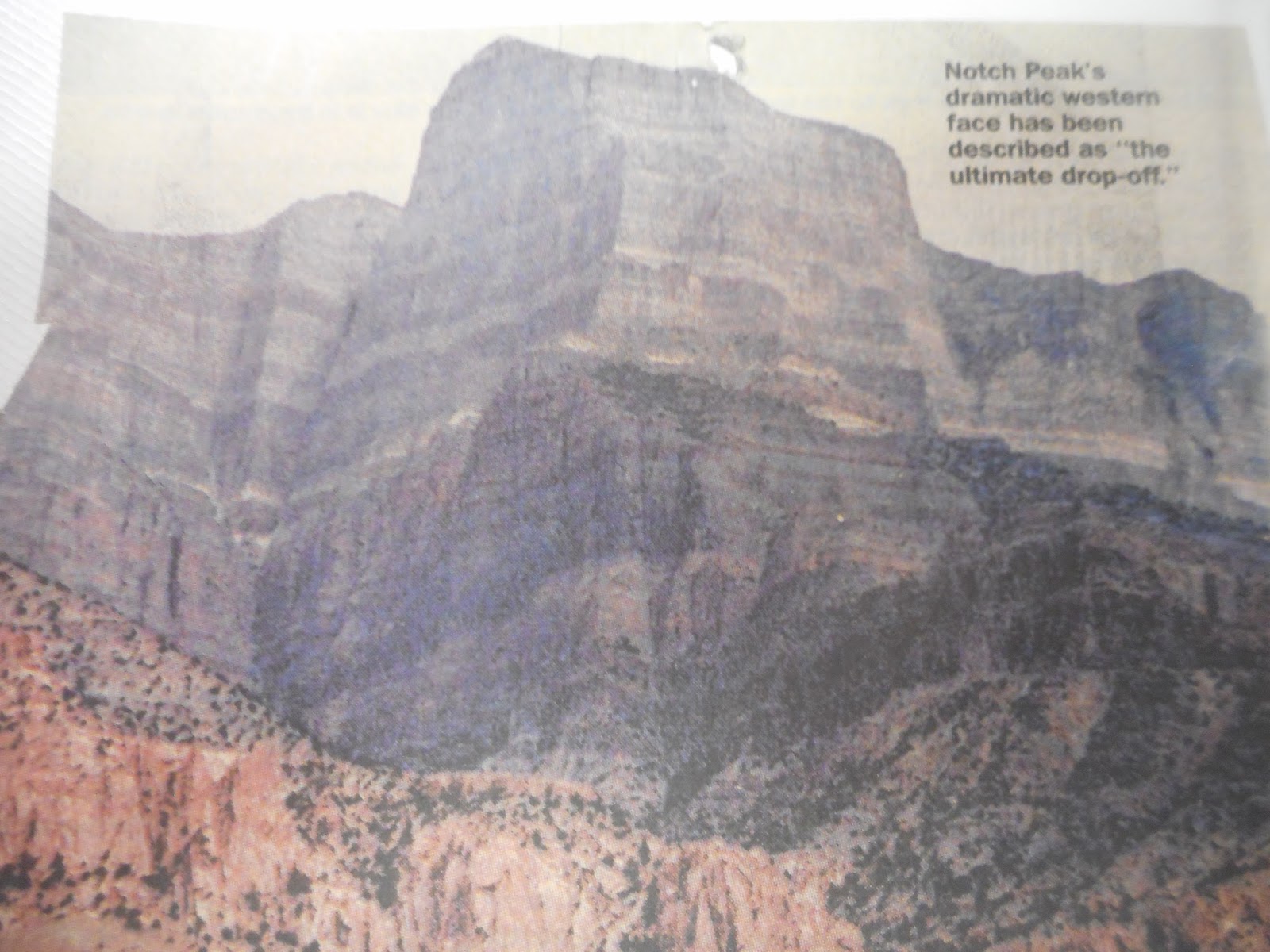
Sheer, steep, lofty, abrupt - adjectives don't do this escarpment justice. John Hart, in his book "Hiking the Great Basin," writes that a Notch Peak climb will refine your use of the word "cliff." It is, he says, "the ultimate drop-off."
A hike to the top begins at the mouth of Sawtooth Canyon, on the mountain's southeast side. A shot-up sign meant to direct motorists to nearby Miller Canyon (the placard on the main unpaved road heading north says " 'er Canyon") sends adventurers west; at a Y intersection, the road on the right heads to Miller, while the one on the left bumps toward Sawtooth.
Sawtooth itself opens with dramatic cliffs. The drainage leading toward the peak turns west then north. The canyon becomes quite narrow, with brushy sides, fallen conifers and a barely discernable trail. Finally hikers head up a ridge toward the peak. Before they get there, though, the mountain suddenly breaks open and YIKES! A massive cleft opens up, a yaw that certainly contributes to the notch visible from scores of miles away. The mountain's limestone foundations swirl in a sequence of sedimentary layers.
From the peak itself, Notch, at 9,655 feet above sea level, drops 5,053 vertical feet on its west side to the bleak but beautiful sagebrush-and-alkali Tule Valley below.
That, as Fergus points out, is nigh on a mile.
Then there's the view from the top: a panorama of desert valleys and distant ranges. On a clear day there are more sights to behold than you may have time to drink in.
"Scenic overdose," two Provo hikers scribbled in a mailbox note.
"I hope you brought your hang glider for an easy descent," wrote Matt and Kristen.
To the east and southeast are Scipio Peak, the Sevier Dry Lake and the Pavant and Tushar mountains. To the south are Utah's San Francisco and Wah Wah ranges. The Confusions are in the immediate western foreground, with the Deep Creeks off to the northwest. Several key peaks can be spotted beyond the Nevada state line - Mount Moriah (elevation: 12,050 feet) and Wheeler Peak (13,061 feet) float far to the west and southwest; Pilot Peak is to the extreme northwest.
And if you hate hiking?
From the northeast, a rugged four-wheel track climbs into the spring-fed Amasa Valley (the locals pronounce it Ama-seh, Fergus adds), past old mining equipment and a collapsed cabin to the Pine Peak overlook. The view toward the Silver State is much the same, without the summit's plunge but with the addition of some nice groves of aspen and pinnacles and boulders of rusty granite.
Near the ridges are enticing campsites, Fergus vouches. His wife loves to stargaze, so he brought her into the area last summer.
"She said she couldn't find the constellations - there were too many stars."
While Notch is gaining a name, some long-time residents of the region are already somewhat famous.
That's "long-time" as in since the Paleozoic, some 400 million years or so ago.
At the S & S Trading Post and Neno's Rock Shop at the west end of Delta, Nina Higgs pulls out a handsome book. There they are: portraits of Elrathia walcott and Ptychagnostus richmondensis (walcott) - two of the 60 species of trilobites found in Utah's House Mountains. Other pictures show creatures found today in such disparate locales as Sweden and Newfoundland.
West-central Utah is famous among rockhounds, Higgs notes. People from all over the world - but especially from the Wasatch Front - visit to seek out topaz near Topaz Mountain to the north, geodes and trilobites. Though long extinct, the latter, small bottom-feeding bug-like animals, are preserved by the millions in Wheeler Formation shale.
The shale is exposed throughout the area. On BLM land, visitors are allowed to chip away at the rock if they want to find a trilobite or two. Collecting is legal, "as long as it's invertebrate" - i.e., no dinosaur bones, which aren't in this vicinity anyway - "and as long as it's not commercial," Fergus says. Technically, then, any discoveries made are not to be for sale, "but it's really hard to enforce; we just don't have the people to do it."
He takes his Blazer off the main track toward gray-green hills. A winding jeep trail leads to a trilobite bed that's semi-secret, though a trench and tons of chipped rock show it has been visited frequently enough. A small pick in hand, within minutes he's revealed a few trilobites: dark, tripartite, scarab-like fossils that look like they could have been embedded there yesterday. Others are found by simply sorting through the debris.
Various BLM and guide maps point the way to such deposits, but few are specifically marked for would-be hounds.
On state parcels - the "school lands" we've often heard about - commercial enterprises are issued permits to excavate. At the U-Dig Fossils pit in Swasey Peak's Antelope Springs drainage, for example, day-trippers are given directions and an opportunity to uncover the ancient creatures.
"That's quite a hole, isn't it," Fergus says. "They've been digging there a long time."
Other beings repose within the rocks as well. Joe Bauman, who writes about science for the Deseret News, heads occasionally to the House Range to look for reddish squiggles that may signify sea life of almost unimaginable age. Trilobites pop out in 3-D; these softer-bodied forms can be more chal-lenging to track down.
"I crack open rocks in hopes of finding some new species of middle Cambrian invertebrate and because I enjoy finding known varieties that are there," Bauman says. The middle Cambrian, approximately 530 million years ago, was a time of great evolutionary diversity.
Some discoveries seem downright alien looking, he says, "like a critter that had seven eyes, paddles and a trunk with a spiky grabber on the end of it." He's sent off several examples to scientists.
For those "who don't want to waste precious time getting there," Neno's offers full- and half-day expeditions into the region, says Nina Higgs. The guides know where the deposits are, provide the vehicle and tools, and bring along water, juices and sanitary accessories.
Rockhounding, she says, is a fast-growing hobby, and "something the whole family can do together." The House Mountains have an open, outdoor appeal in themselves, and the fame of the region's rocks is spreading.
"We see people from all over the world, every walk of life, every nationality."
Like other dramatic Utah settings, the House Mountains tend to make you wish you were a geologist, or at least a better student of the subject.
Great Basin block faulting created the mountains, tipped them up, stretched the valleys and cracked the massive rocks to make narrow canyons. Erosion ate away at the peaks and filled the gaps between then.
"The alluvium in these valleys," Fergus says, "is something like 10,000 feet deep."
All this began some 18 million years ago, according to Halka Chronic's book, "Roadside Geology of Utah," when "stretching, thinning and breaking of the Earth's crust began to create the Basin and Range mountains of western Utah, Arizona, Nevada and California. . . . In Utah, most of the ranges are steeply faulted along their western sides. Geologists soon likened this region to a pile of dominoes all tilted in the same direction."
Another shaper of the landscape was the Pleistocene's Lake Bonneville, the fresh-water ice-age ancestor of the Great Salt Lake that covered vast stretches of territory. The shorelines remain visible along the mountainsides and on hills that were once islands.
Yet another ingredient is molten rock. At some point millions of years ago, magma seeped into the sedimentary foundations of Notch Peak. The intrusion created a becoming red-tinged granite visible in Miller Canyon, the Amasa Valley and on the western side of Notch. And that granite, to prospectors of the 19th and 20th centuries, hinted at precious metals like tungsten, silver and gold, which tend to migrate to the edges of such rock when it is being formed.
And so there are mine claims in the House Range. Some date back a century; others are on state lands: an old wood-and-rock miner's cabin reposes near Sawtooth Canyon; sluice operations continue intermittently in the gravels of Miller Canyon; the Amasa Valley is sprinkled with mine heads and old equipment.
There's no indication anybody hit a motherlode here, so you have to wonder: Did the mine operators get their investment back?
"No, in a word," says Fergus.
But still people have been drawn to the House Range: There's evidence that Archaic Indians were here 10,000 years ago; the Paiutes and other tribes in more recent times; prospectors, cattlemen and cowboys, sheepmen, freight haulers looking for a way through, road builders - and a hermit. Bob Stinson, a World War I veteran, lived in Marjum pass for years and years. In a side canyon he built a one-room home with rock walls under a sheltering cliff.
"How would you like to spend 17 years of your life here?" Fergus wonders.
But rockhounding, hiking, hunting, cave spelunking (Antelope Cave is open during part of the year), hobby mining (as Fergus puts it) and other recreational pursuits seem to be part of the future for these mountains and valleys.
That makes people like Fergus and Higgs a bit apprehensive.
Old-time miners didn't tend to clean up after themselves much, but modern recreationists can be just as careless: You can't help but notice the accumulation of cans and bottles in prime primitive camping spots. ATVs and four-wheel-drive vehicles can do serious damage in such terrain.
"What you get out in this area is someone will cut out into the brush and someone else will come along to see where they went. Pretty soon you have a `road,' " says Fergus, one of whose jobs is to keep an eye on three wilderness study areas in the vicinity.
Higgs, too, expresses concerns about how people treat it, from traveling across the valleys to finding a place to potty.
"In the past five years I've seen it grow so fast. I'm not sad - I'm trying to make a living off it."
Yet, she adds, "People think the desert is forever, but it is fragile."
-By Lynn Arave and Ray Boren and originally published in the Deseret News, Aug. 24, 1997.


The Origin of the Names of Utah's 29 Counties


Here are stories behind the names of Utah's 29 county names:
Beaver County: Recognizes the plentiful beaver in the area.

Box Elder: Box Elder trees east of Brigham City apparently inspired the name.
Cache County: First called Willow Valley by a trapper. Also referred to as Logan's Hole in memory of Ephraim Logan, who was killed near Jackson, Wyo., by Indians in the mid-1820s. The Cache name is said to have been applied after a trapper, employed by the Rocky Mountain Fur Co., was killed during a cave-in while excavating for stashed furs (caches).
Carbon County: Named for coal deposits in the area.
Daggett County: Ellsworth Daggett is the source of the county's name. The first Utah surveyor general, he surveyed an irrigation canal in the county.
Davis County: Named for Daniel C. Davis, a captain in the Mormon Battalion, who died in 1850.
Duchesne County: The source of the name is uncertain. The word supposedly came from the Duchesne River, but before 1875 the river was known as the Uinta River. So, there are six other possibilities: 1. Du Chasne, possibly an 1830s French trapper in the area; 2. an early Indian chief in the region; 3. Rose Du Chesne, founder of the Society of the Sacred Heart in America; 4. Fort Duquesne, built by the French in 1754 in what became Pittsburgh, Penn.; 5. the Ute Indian word,"doo-shane," meaning dark canyon; 6. Andre Duchense, French geographer and historian.
Emery County: Named for George W. Emery of Tennessee, who was appointed governor of Utah Territory in 1875. (Some residents wanted to name it Castle County.)
Garfield County: Received its name in 1892 in honor of U.S. President James A. Garfield, who was assassinated in 1881.
Grand County: Established in 1890 and named for the Grand or Grande River, now the upper Colorado River in the area. It was in 1921 that the name "Colorado" was extended upriver beyond the confluence with the Green.
Iron County: Originally called Little Salt Lake Valley County, the name was later changed to Iron County as a reminder of the iron mines west of Cedar City, which was the Mormon Iron Mission.
Juab County: The name comes from what Indians called the valley, apparently meaning level plain or flat. Another variation of the word is said to mean thirsty valley.
Kane County: Named for Col. Thomas L. Kane, friend of the Mormon settlers.

Millard County: Honors U.S. President Millard Fillmore.

Morgan County: Jedediah Morgan Grant, father of LDS President Heber J. Grant, is the source of the name.

Piute County: Recognizes the Piute, or Paiute, Indians who inhabited the region.
Rich County: Originally created as Richland County, the name was later shortened to Rich. The name came from Charles C. Rich, an early Mormon apostle and prominent settler in the Bear Lake region.
Salt Lake County: Named for the nearby Great Salt Lake.
San Juan County: There's a slight dispute on this county's name origin. Most credit it to the San Juan River, in turn named for one of two early Spanish explorers in the area. Both Don Juan de Onate and Don Juan Maria de Rivera are credited as sources for the river's name.
Sanpete County: The name is a variation of San Pitch, who was a Ute Indian chief who lived in the area.
Sevier County: Named for the Sevier River. The name is a variation of Rio Severo, a Spanish word meaning severe and violent. The river also had other names, such as the Ashley River. Some incorrectly believe the county was named for Brigadier Gen. John Sevier of Kentucky.
Summit County: This name came from the county's high country. Summit encompasses 39 of the state's tallest named peaks - the most of any county in Utah. (Second is Duchesne, with 28, but Duchesne also has Kings Peak, the state's tallest at 13,528 feet above sea level.)
Tooele County: Spelled "Tuilla" at first and later changed. The origin is a subject of dispute. Some believe it came from a Goshute Indian chief named Tuilla. Others say the word refers to the rushes and weeds so common in swampy areas of the valley.
Uintah County: Named for the Ute Indian tribe that lives in the basin. Early maps put an "H" on the end of the word. John Wesley Powell left the H off in his writings, and as a result both variations are in use.
Utah County: Apparently Anglicized from "Yuta," which is what the Spanish explorers called the Ute Indians. The name probably means meat eaters.
Wasatch County: A Ute Indian word meaning "mountain pass" or "low place in a high mountain." This Ute word was a general reference to Weber Canyon, the lowest cut in the Wasatch Mountains.
Washington County: Named in honor of George Washington, the first U.S. president.
Wayne County: Supposedly named for Wayne Robinson, son of state legislator Willis E. Robinson. A counterclaim for the name's origin indicates it honors Revolutionary War Gen. Anthony Wayne.
                       Weber County sign in lower Weber Canyon.
Weber County: This is the name with a very uncertain origin. Consider some of the different possibilities:
- The book "Utah Place Names" indicates the name probably came from John W. Weber, a trapper killed by Indians near today's Weber River in 1823.

- The Weber River and Weber County could have been named for another trapper, Pauline Weaver, who became a frontiersman in Arizona, according to "Weber County . . . Yesterday, Today and Tomorrow." The name Weaver was corrupted to Weber. The book also refers to the story of John Weber, indicating he was killed by Indians near the river in the winter of 1828-29.
-Some have suggested the name came from a member of Peter Skene Ogden's trapping party. However, Weber is a not a French-Canadian name. So, it may be Capt. John G. Weber of Danish nativity who is the namesake. He is said to have died in 1859 in Bellevue, Ill., according to an undated historical sketch of Weber County.
- John H. Weber was in the Ogden area from 1822-27 and discovered the Great Salt Lake, Weber Canyon and the Weber River, summarizes the book "Beneath Ben Lomond's Peak."
- Weber County, says "A History of Ogden," was named for Capt. John B. Weber, who was with trappers in the area until 1827. He died in Iowa in 1859.
- Several other books, such as "Utah: A Guide to the State" and "Ogden: Junction City," simply state the river and county were named for "Capt. Weber." John G. is listed in the first of those books; John H. is named in the second.


-By Lynn Arave and originally published in the Deseret News, Jan. 5, 1996.


Beehive Peak: Utah's 'Red Pyramid'


                    Beehive Peak from the valley below.
                                             All photographs by Ravell Call
AS seen from the valley below, a prominent summit on the edge of central Utah's Pahvant Plateau looks like the state symbol — a beehive.
But while Beehive Peak, west of Aurora, could conceivably be a candidate for the state's official mountain, from another angle it summons up a different locale: Egypt.
From vantages 3,000 feet higher, on the plateau's rugged roads, Beehive Peak looks like a mysterious — possibly even man-made — red pyramid.
               Beehive Peak from the mountain ridge.
The peak, in Fishlake National Forest, is a prominent landmark for much of Sevier County, especially the communities of Aurora, Salina and Redmond. Its two faces make it one of Utah's most unusual mountains, though it isn't listed on the state highway map.
"It just stands out," says Bill Wright, a ranger with the forest's Fillmore District. "It's a nice red in color."
Max Reed, a ranger in the Fishlake National Forest, would agree. "It's really quite pretty when the sun hits it," he said.
"For me it's security," said Richard Wasden, a rancher who has cattle each summer in the Beehive Peak area. "You wake up and there it is." He uses it as a landmark to know where he is on the mountainous plateau.


The "distinctive pyramid of Beehive Peak" is how Peter Massey and Jeanne Wilson describe it in their new book, "4WD Adventures Utah."
Although the Willow Creek Road/Piute ATV Trail, usually open late June through October, comes within about three miles of the mountain, there is no developed trail to the peak itself. Those interested in getting to it have to bushwack and maneuver through a maze of cow trails, ridgelines and scree to its base.
Once there, layers of a sheer "China wall" circle the summit. The rugged formation is also composed of a brittle sandstone material that makes it extremely difficult — as well as dangerous — to climb. Trees growing on the peak's sides make it appear climbable from a distance, but close-up the spot has a rugged Bryce-Canyon look.
                 Closeup view of Beehive Peak.
Still, daring hikers have conquered not only the protective walls but Beehive Peak itself.
Steve Camp, 42, of Salina is one them.
"I was surprised at how difficult it was," because of the steepness and the loose, brittle rock, he said. Camp found a crack in the natural walls around the summit's southwest side and reached the pyramid's base. He made his final approach up the peak on the northwest side. "There were some cliffs to shimmy up."
Camp has since met a few others who have reached the top, and they agree Camp's route is the best approach.
It's such a magnificent landmark that — having grown up in the area — he said he had to try to climb it. And he would like to so again.

The red rock that composes Beehive Peak is believed to be material shed from an ancient mountain range that preceded the Pahvant Range. Camp said nearby Red Canyon also contains interesting rock formations.
Beehive is overshadowed in height by four other peaks nearby — Jack's Peak (10,072 feet); White Pine Peak (10,215); Coffee Peak (10,005) and Willow Creek (9,765).
However, like some Egyptian monoliths, it is Beehive's shape that startles and attracts.
Also, "It's further east than the rest of the higher peaks," Wright said, and therefore more prominent to those in the valley below.
Surrounded by three deep canyons — Sweetwater, Red and North Cedar Ridge — Beehive Peak can also be spotted along the eastern end of U.S. 50, between Scipio and Salina, and along portions of U.S. 89 and I-70.
Closest access to the peak is the Willow Creek Road, a truck, four-wheel-drive or ATV dirt highway also known as U.S. Forest Road No. 102. Access is also possible from Richfield on a dirt road past the Redview Guard Station on Forest Road No. 96 that connects with the Willow Creek Road.
Mount Nebo is visible to the north from near and atop the Pahvant Plateau. Mary's Nipple is the most prominent peak to the east across the Sevier Valley. The Tushar Mountains can be spotted to the south. Fall leaves also make the Willow Canyon area a spectacular drive in autumn.
-By Lynn Arave and originally published the Deseret News, Oct. 18, 2002.
Contributing: Ray Boren, with photos by Ravell Call.


Utah Highway Facts and Fancy


                Highest paved road point in Utah, Bald Mountain summit.

OVERALL, Utah's highways provide a pleasant contrast of geography for sightseers, with paved and unpaved roads traversing some of the nation's most spectacular scenery.
Besides U-143 being Utah's steepest paved road with a 13 percent grade, the following tidbits about other Utah highways have been gathered from Utah maps, the Utah Department of Transportation and other sources:
·         Highest paved road in Utah — Mirror Lake Highway (U-150), which crosses Bald Mountain pass, 10,759 feet above sea level. The road is usually open June to early November, depending on the weather. Its latest-ever opening was June 29, 1995.
·         Highest paved road along the Wasatch Front — The Mount Nebo loop road that reaches 9,353 feet above sea level at the Monument trailhead.
·         Highest gravel road in Utah —From Big John Flat to a high ridge in the Tushar Mountains, between Beaver and Marysvale, at 11,500 feet above sea level.
·         Highest gravel road along the Wasatch Front — Skyline Drive in Davis County between Farmington and Bountiful. A spur road that heads north to the Francis Peak radar domes above Fruit Heights tops out at almost 9,500 feet above sea level. The road is passable by cars in the summer.
·         Lowest elevation paved road — River Road in Washington County south of Bloomington Hills and St. George at 2,697 feet above sea level.
·         Lowest elevation unpaved road — Several jeep roads in the Beaver Dam Wash area, west of St. George, that approach 2,500 feet in elevation.
·         First Utah roads to be hard-surfaced — Richards Street, in downtown Salt Lake City, from South Temple to 100 South and also State Street, from South Temple to 400 South — both in 1891 and probably paved with a combination of granite blocks, asphalt and brick. Main Street, in Salt Lake City — from South Temple to 300 South, was the next street paved.
·         Longest straight stretch of road — I-80 on the Salt Flats between Wendover and Knolls with an approximately 50-mile straightaway.
·         Longest tunnel — Zion-Mount Carmel Tunnel (U-9), 5,613-feet long, the nation's fifth-longest land tunnel. It opened in 1930 and is in Zion National Park.
·         Worst paved road test for acrophobiacs — Probably U-12, between Escalante and Boulder, where the highway traverses a knife-edge with high cliffs on both sides of the roadway and no guardrails.

-By Lynn Arave and first published in the Deseret News, May 26, 2000.