Monday, April 1, 2024

Sixteen Vintage Photographs of Lagoon Park

 What follows are 16 vintage/old photographs of Lagoon Amusement Park, Farmington, Utah.

All pictures are from the Deseret News Archives and most are from the 1960s, or earlier....


This picture shows Lagoon's 3 main buildings, probably from the late 1880s, when it was located by the Great Salt Lake, 3 1/2 miles west of where it is today....


This photo shows visitors to Lagoon in the summer of 1898... Only a few years after the park moved eastward.


The Deseret News story in November of 1953, after the fire that caused significant damage to Lagoon and its owners' pledge to rebuild.


The east end of the roller coaster was destroyed by the fire in November of 1953.


This is the Lagoon "Showboat," that cruised the park's lake in 1959.


This is Lagoon's Patio Gardens, in 1959, where many famous bands performed over the decades.


The Wishing Well at Lagoon was a centerpiece of Mother Gooseland at Lagoon in the late 1950s and into the 1960s.


These slides were probably the most popular fixture inside the last Fun House at Lagoon. Riders slid down on a gunny sack...


This rotating tunnel was worth a crawl inside the Fun House, at Lagoon Park of old.


This high speed, spinning wheel was also inside Lagoon's Fun House. Unlike its nearly flat counterpart wheel, where riders got kicked off and the last person left on won, this wheel just pinned riders to the side of the bowl-like wheel by centrifugal force.


Lagoon's former "Million Gallon Pool, with water fit to drink," was the predecessor to today's Lagoon-A-Beach. Note the tall metal slippery slide, that the pool also featured.


Lagoon's old swimming pool boasted a variety of diving boards in its deep end.


This "Flying Swings" ride lasted just a single season in 1964, before it was replaced.

These "Paddle Boats" at Lagoon were foot and pedal powered only. They were gone by the early 1980s.


The Space Scrambler ride is shown running in the mid-1960s.


An actor/stuntman falls in a wild west show at Lagoon's Pioneer Village, during the summer of 1976, its inaugural season.


Saturday, July 1, 2023

The 'Fruit Heights Dinosaur' appears on the mountainside


Look at the dinosaur-like shape, south of the Francis Peak Radar domes, Picture taken from Layton's Main Street at 1000 North.                                                         Photo by LeAnn Arave.

  A new animal-like shape in the snow appeared on the Wasatch Mountains, above Layton on June 30, 2023.

 Located south of the famous “snow horse,” this snow shape is south of and just below the Francis Peak radar domes and resembles a dinosaur with a long tail in this view. In other views, it looks more like a horse and some on social media say it looks like a dog, dragon, or even a kangaroo.

 Perhaps the shape could be titled the Fruit Heights Dinosaur, since that's the closest town to it?

  The author has never seen this shape appear in at least the last 32 years, so it may relate to all the extra snow the Wasatch Front received in the winter of 2022-2023. If so, the shape may not reappear for decades. It may also mean that subtle changes in the Wasatch Mountains occur more often than commonly believed.

  On July 1, 2023, the actual snow horse shape hit a  rare milestone, with half of it still being visible. In pioneer legends, that meant water would flow from all the Wasatch Mountains creeks all summer long, if any part of the snow horse was still visible on July 1.

 
                                                 Another view of the new animal shape.


Sunday, March 26, 2023

1917: When the Logan Temple was "destroyed by fire"


                                                           The Logan Temple.


 IT is intriguing how different newspapers reports of the same event can be.

Example: Here are three Utah newspaper headlines for December of 1917:

-"Logan Temple is damaged by fire," Salt Lake Tribune, December 6, 1917.

-"Fire destroys Logan Temple," Logan Republican newspaper,   December 6, 1917.

-"Logan Temple destroyed by fire," Box Elder Journal, December 7, 1917.

  The Salt Lake Tribune story stated that a fire on December 4, 1917 caused $75,000 in damages. The fire had started in a closet under the main stairway, on the east end of the building. Nearby residents spotted the fire and called the Logan Fire Department.

 The Tribune report continued:  Firemen responded and the blaze was quickly extinguished with just one hose. However, then minutes later, a second fire broke out, this on the third floor and threatened to engulf the entire Temple. That fire required the firemen's largest hose and lots of water to put the blaze out. It was later discovered that the closet where the first blaze began contained a main electrical switchboard and that is likely how another fire began, by electrical wires two floors up. The initial blaze was sparked by an extremely flammable mixture of polish that the temple's janitor had left in the small closet. Then, some electrical wires melted on the switchboard and sparks hit the polish and ignited the large fire.

  The Logan Republican newspaper story reported that the Church had no insurance on the temple.

  The Box Elder newspaper stated, "The beautiful Logan Temple was entirely destroyed by fire Tuesday evening. Of course, the walls remain, for they are of stone. Almost the entire interior of the structure was burned to ruins." The fire started at 7:45 p.m., when no one was inside the temple. Damage was estimated at $100,000.

  The Logan Temple opened in 1884 and cost $500,000 then to construct.

 Just over three months later, Logan Temple reopened on March 11, 1918. The Salt Lake Telegram reported on that day that $30,000 were spent on materials, to replace those destroyed or damaged in the fire. Countless thousands of dollars were saved in free labor donated by Church members in Cache County.

-There was also an earthquake that caused significant damage to the Logan Temple. On March 27, 1975, 7:31 p.m., a magnitude 6.0 quake occurred 15 miles southwest of Malad City, Idaho. This quake was felt all over the Intermountain area. Several years later, a close inspection of the Logan Temple during a renovation, revealed that the main wooden support beam on the roof of the temple had cracked in the quake.

  According to the late Fred Baker, chairman of the Church's Physical Facilities, from 1965-1991 (interviewed about this in early 2012 by the Church History Department), this is why the Logan Temple renovation, from 1977-1979, was so extensive. Most of the inside of the temple had to be gutted and rebuilt. Sadly, some spectacular paintings were also removed and never replaced. 

  Brother Baker stated:

  "When they took it (the inside of the Logan Temple) down, we found that the main structural beam had cracked right in two from an earlier earthquake. If you had redone the temple and put the First Presidency and all the people up there on that (upper) floor, it may have totally collapsed. After all that, the Presidency told Emil (Fetzer, Building Committee member), 'Thank goodness you were wise enough to completely remodel the Logan Temple.' But local people hated us for touching their temple, and I could understand that. We never received that kind of response from the local members when we did the other temples. We did all thirteen existing temples, but the Logan Temple was the only one that we got such a negative response on." 


Friday, August 6, 2021

Newspapers.com equals the only real time travel


Newspapers, like the Deseret News, have a wealth of information in their archives.


 HAVE you ever dreamed of traveling through time?

 OLD newspapers are the only known way to do this.

Newspapers.com offers an almost endless archive of old newspapers from across the country -- and even some foreign entries.

Just search by name or keyword and it is amazing what can be found about parents, relatives and others.

Until the late 1970s, EVERY speeding ticket and fender bender were usually printed in local newspapers. Also, coverage of weddings used to be very detailed with the names of the entire wedding party. 

Some former classmates or friends, who one has lost track of, might be able to be located through old newspapers. At the least, it is almost always possible to find out what they did before the year 2000 or so. (Not everyone is on Facebook.)

You don't have to rely on library shelves for historical information these days, just the Web.

If a person is in their 50s or more, they will especially be excited about what can be found about relatives and friends. Even some of their own accomplishments, that they didn't know were even in a newspaper back in the day, might be discovered.

But be warned! These searches can create some family mysteries that may not be fully solved, because key people involved might have passed on. So, don't wait too long to do newspapers searches.

The author personally found that an uncle had survived a head-on collision with a gasoline tanker; that his great-grandfather constructed the first bridge in Morgan, Utah -- and much more. 

Newspapers.com also offers a free, seven day trial.


                            One of the original Deseret News presses, from the 19th Century.,

Saturday, June 19, 2021

Hooper, Utah Cemetery boasts the grave of "The Last Leaf on the Tree'


                              The modest Mary F. Garner grave at the Hooper Cemetery.


THE Hooper, Utah Cemetery can rightfully brag about having the grave of “The Last Leaf on the Tree” –  Mary Field Garner ---- The last person in mortality who was acquainted with the Prophet Joseph Smith, first president in The Church of Jesus Christ of Latter-day Saints.

Is this not significant? 

After all, Clarkston, Utah, in Cache County’s key claim to fame is that “The Man Who Knew” – the last home for Martin Harris, one of the Three Witnesses of the Book of Mormon, is buried in that City Cemetery.

                                      The elaborate Martin Harris Grave in Clarkston, Utah.

A Deseret News story on August 21, 1943, by Bishop Marvin O. Ashton of the Church’s Presiding Bishopric is the source of “The Last Leaf on the Tree” comparison.

Mary Field Garner was born in England on February 1, 1836. She died at age 107 on July 20, 1943. At the time, she believed to be the oldest ever member of the LDS Church.

“At the time of the (Prophet’s) martyrdom she was eight years old and remembers vividly the day that people rose in their seats, when Brigham Young, as it were, was transfigured into the personality of the prophet,” Bishop Ashton wrote in the Deseret News.


Ironically, she also had a rather embarrassing confession about that transfiguration story – she was tending an infant on her lap in that meeting. Her parent’s had brought a tin cup along as a plaything for that baby and yet just as Brigham Young rose to his feet, the tin cup fell to the floor and created an embarrassing noise.

Sister Garner had lived in Slaterville, but moved to Hooper and resided there for many years, where her last five of 10 children were born, and where she passed away.

                         A view of the Hooper Cemetery.

Of course, with 107 years of life, Sister Garner has a long, long story to tell of traveling across the plains to Utah and of the territory and the State of Utah’s early history. 

This writing will not delve into all of that, as the detail is substantial – but can be accessed on other sources listed below:

https://www.newspapers.com/clip/74672893/hooper-utahs-claim-to-fame

https://history.churchofjesuschrist.org/overlandtravel/sources/6068/garner-mary-field-autobiographical-sketch-ca-1940-8-9

http://archives.lib.byu.edu/repositories/14/resources/5367

https://www.findagrave.com/memorial/26082465/mary-garner

https://mchangroverheritage.wordpress.com/2019/01/06/the-last-leaf-mary-field-garner/


Saturday, May 22, 2021

Kanarraville Falls -- A Local Secret for Decades


                                               The sign at the edge of the parking lot.

                             The station where hikers are checked in and permits are taken.


THE Kanarraville Falls, a 5-mile roundtrip hike, is the hottest scenic rage in southwest Utah these days.

Indeed, in 2021, the hike sold-out for most of the summer in early May ...

Fueled by Kanarra Creek, this small slot canyon named Kanarraville Canyon, was a secret known to only locals for many decades. (Kanarraville is a small town about 13 miles southwest of Cedar City, along I-15.)


                        The first section of the trail is a brisk uphill on an old road.,

An exhaustive old newspaper search on the waterfalls reveals nothing until the 21st Century.

     Looking down on the trailhead parking lot, with 2 sections and the restroom in between.

Indeed, "Best-kept secret becomes nightmare," was a June 25, 2017 Associated Press story in the Daily Sentinel newspaper of Grand Junction, Colorado and many other western newspapers that summer.

The S.P. story said the first time that town members noticed that their little slot canyon was no longer a secret was on July Fourth weekend of 2004, when 75 cars were crowded into the trailhead's parking lot.

                 Twin Kanarraville City water tanks after the trail levels out for a bit.


               Another warning sign about being cautious on the rugged trail.


  The Bureau of Land Management Sign, just before the first chance to cross the stream.


                                      The first time the trail crosses Kanarra Creek.

How did the community keep it secret for so long?

"Very carefully," responded the ticket taker/security guard at the gate to the trailhead.

A hiker from Ohio said he was told that when the Zion Narrows were closed due to high water in 2004, that's when National Park Service , who knew about the smaller canyon, referred hikers to Kanarraville -- and it took off from there. The secret was out and social media exploded its popularity.

                 The early trail has some uphill, downhill, etc., as it goes back and forth.


                                        Finally! The actual mouth of the canyon.

Kanarraville Falls is indeed a mini Zion Narrows experience.


                    The second stream crossing and where most walk in the water.


                       The final sign along the trail, adjacent to the fenced-off City's well.


                                         Walking in water is now a complete necessity.


                                            The first mini Zion Narrows experience!

Kanarra Creek is the town's main source of drinking water (along with a spring near the creek)  -- and therein lies a big concern regarding pollution. Gates were placed along a road leading to the mouth of the canyon, to prevent parties from being held there, where some had hauled couches and other amenities up the mountain.


                                  Narrow going here and an excellent experience.


The ladder is reached here. It is not as bad as it looks, but go slow and make sure you have both hands free when climbing. There is a sturdy chain to grab and hold onto near the top. Mist may hit you.


A closeup of the ladder, with metal rungs. Be sure to slowly descend on the return trip, turn around, with your face facing the ladder.


                                  A view when the ladder is a crowded place, with a line.


                                                Looking down on the ladder climb.

By the end of the 2015 hiking season, more than 40,000 people had been counted as visiting the falls. Then, Kanarraville City decided to pay for an actual parking lot at the trailhead. Then, they charged $10 a person to hike the trail, to fund the improvements.

In 2016, the parking lot grossed $95,500 in fees.

As of 2021, that fee is $12 a person and there is a limit of 150 hikers per day. Finding the trailhead is easy, as the City has road signs posted in town.


This is actually the most dangerous part of the Kanarraville trail. You have to scale the logs and scramble up large boulders above that. Not only can the timbers and rocks be wet, but there's only a rope on the very bottom section to hold onto.


                                                                        Going up!

Restrooms are water are available at the trailhead. Sturdy sandal shoes or aqua shoes with good tread are a plus along this path, because you are walking in water most of the time along the upper route. Also, the taller a hiker is, the easier some of the scrambling on this hike is.

One hiking pole a person, is also a wise idea, to help maintain balance and test the depth of the water ahead in the deeper pools.

A considerable amount of scrambling is required along the upper portions of the trail. Thus, children 10 and under, require assistance and supervision along the way. In fact, though much shorter than the Zion Narrows, the 700-foot elevation change and the scrambling make Kanarraville a harder hike than the Narrows.


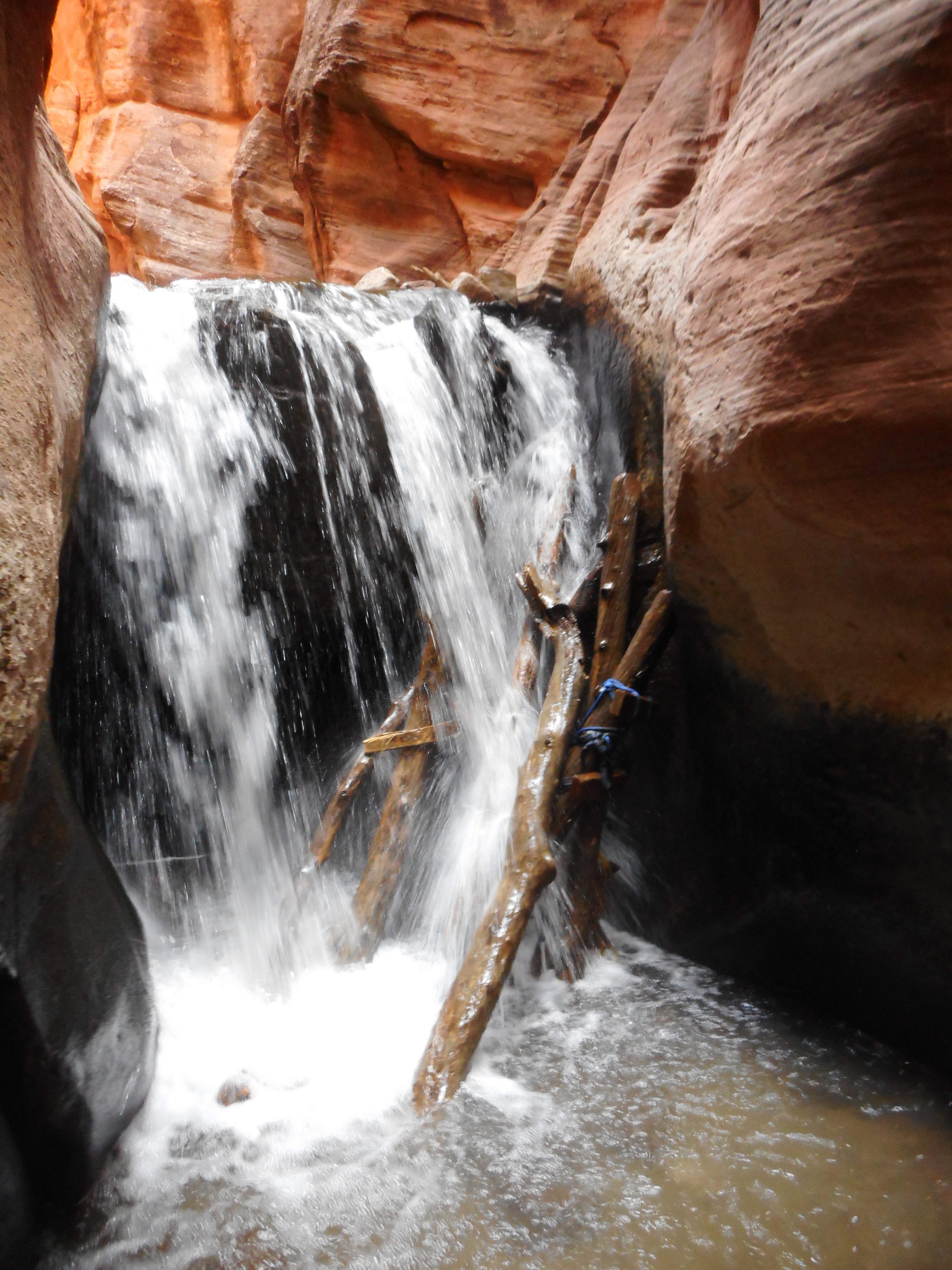
                           The second and final waterfall. Do NOT attempt to go above here.

Personally, I would not take any kid under 12 on this hike, all the way to the second waterfall vs. Kids age 8 and older usually do fine on a day hike of the Zion Narrows.)

The first 0.8 of a mile along the Kanarraville trail follows an old canyon access road and crosses the stream twice. With its up and downs, that is endurance wise, a very difficult portion of the trail.


                                                     A closeup of the second waterfall.

The first waterfall is 1.6 miles up the trail. A 15-foot ladder with metal rungs, but no handrails, must be scaled to continue from this point. Although it may appear challenging, the ladder is firmly secured in place, though nearby rushing water splashes over the ladder. (Returning hikers will best descend this ladder backwards and feet first.)

At 1.7 miles out is a spot with several logs and a tall boulder that must be climbed. This is where many injuries from falls have occurred on the trail. There is a rope attached to the lower portion of this spot, but not the upper part. (Having an anchored chain there could reduce injuries, but the City has no done that.)

The second waterfall is 1.9 miles up the trail. It is preceded by the narrowest section of the canyon, that also has the deepest water.

          With one hiking pole, traversing up and down  on the stream walk is so much more sturdy.

(In a mid-May of 2021 Kanarraville hike, the water depth never quite reached my knees. With a lot of photo taking, the hike lasted 4 hours for my group.)

Hikers should not try and go beyond the second falls.

Some sections of the trail have multiple path options for short stretches. Sometimes it is also a gamble on which is easier -- walking in the stream, or taking a rock side path.

In addition, to dangers from falls, rattlesnakes also live in the area and so look out for them. (My group heard a rattler on the hike nearby at about 1.4 miles up the trail, but did not see the reptile.)

Prior to the public discovery of Kanarraville Falls, the town of Kanarraville's claim to fame was that in the early 1960s, some California residents camped near the mouth of Spring Creek (one canyon south of the Falls Canyon). The group of some 26-plus residents, spent more than six years there, pioneering and living off the land.


Starting the hike by mid-morning means you will have some sun shining down to highlight your photographs, assuming you reach the narrow sections by early afternoon.

Small gold deposits were also found in the mountains east of Kanarraville in 1939, according to the Salt Lake Tribune of Feb. 3 that year.

-Kanarra Creek also caused some flooding in town during the spring of 1912, according to the Iron County Record newspaper of May 17, 1912.


                                Two people can barely walk by one another in these narrow sections.


-Kanarraville is named for a local Piute Indian leader from the 19th Century. This band of Native Americans frequently camped near where the town is today.

 -Kanarraville Falls is on Bureau of Land Management terrain, though the City administers it, because of watershed concerns.

-No dogs are allowed on the trail.

-Kanarraville residents also have no easy access to the trail. They must, like everyone else, secure a reservation and pay the fee. (However, we observed two different hikers, both with dogs, who were allowed access through the gate and yet only went less than a mile up the trail. They might have been locals?)


        Even with only 150 hikers a day allowed on the trail, it can be crowded at times ....

For trail fees, information and reservations, go to:

https://www.kanarrafalls.com/

AND, yes accidents have happened to hikers on the Kanarraville Falls trail. So, be careful there.

Some examples:

-"Teen falls 60 feet at Kanarraville Falls," was a May 16, 2013 story in the Daily Spectrum newspaper of St. George. The 16-year-old Las Vegas boy had to be rescued out of the canyon and suffered several broken bones. The boy was attempting to hike up a slippery slope to see where the water originated above a rock.

-"Injured hiker expressed gratitude for search and rescue's response," was an Aug. 3, 2004 headline in the Spectrum newspaper.  A young woman from Arizona broke her leg after falling near one of the canyon's two waterfalls.


                        Take only photos on your Kanarraville hike and haul out any trash.