Thursday, October 15, 2020

Back when dumping raw sewage into the Great Salt Lake was the norm

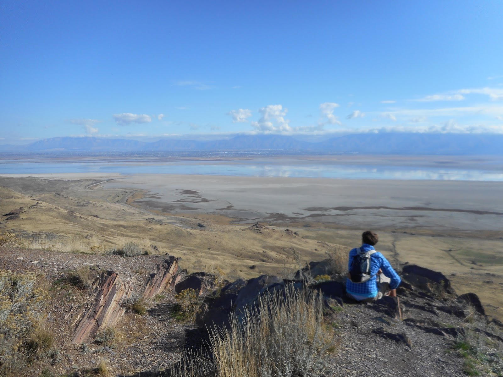
                          A diminished Farmington Bay as viewed from Antelope Island.

UNTIL the 1960s, dumping raw sewage into the Great Salt Lake was a continual and normal practice along the Wasatch Front.
While the Great Salt Lake was one of Utah's best known attractions, it had been a cesspool for decades.
Davis County leaders finally realized in the late 1950s, that this was not a good environmental practice. "North Davis' sewer treatment plant made ready to operate," was a headline in the Weekly Reflex newspaper of Oct. 2, 1958.

                    The North Davis Sewer District facilities, located west of Syracuse.

This facility cost $1.3 million and featured a high rate filter that was the first of its kind in Utah. The plant was designed so that its water emissions were not harmful to any animal.
Central Davis and South Davis County also developed their own similar sewage plants soon after.
"Construction moves ahead on sewer" was an Oct. 6, 1960 headline in the Reflex, as the Central District in west Kaysville proceeded to build a sewer treatment plant.
However, it was Salt Lake City who stalled on creating a sewage treatment plant.
"Outmoded sewage system mocks modern S.L. pride" was a Jan. 29, 1958 headline in both the Deseret News and the Salt Lake Telegram newspapers.  "Salt Lake prides itself on being a modern city," the story stated. "It is a modern city without a modern sewage system. It is modern city which inflicts raw sewage upon its neighbors to the north and which closes large areas to development because of lack of sewage facilities."
The story reported that there were four badly needed sewer projects in northern Salt Lake County -- a modern sewage treatment plant; a sewer line on Redwood Road; a sewage line on 300 East; and an airport sewer extension.

                  Farmington Bay is to the right (south) of the causeway to Antelope Island.

Yet, even more than three years later, these problems were not solved and Davis County in particular was the most upset. "Davis rakes disposal plant plan" was a March 14, 1962 headline in the Salt Lake Tribune. Salt Lake City was then considering a plan to put a new sewage treatment plant at the southern end of Davis County, just beyond the city limits of North Salt Lake City.  
North Salt Lake City leaders wanted at the least, for such a facility to be west of Redwood Road if it was going to be in Davis County.
"Davis County set the pattern in location of disposal plants by placing them in areas which would not distract from any present facilities," North Salt Lake Mayor Clay Allred said.
Finally, in late 1965, Salt Lake cleaned up its sewage emissions.
"'Cesspool' abandoned after 25 years" was a Sept. 14, 1965 headline in the Salt Lake Tribune. The story stated that the "biggest open-ended cesspool in the country" was now gone. The Tribune had declared that superlative 25 years earlier.
In the fall of 1963, Salt Lake began work on a sewage plant and  it was at the northern edge of Salt Lake County. The end result was described as a first-class plant that cost $8 million and was under the proposed budget.
Notwithstanding those environmental strides, the Deseret News report on April 20, 2002, that "Farmington Bay is a sewage treatment pond." Three sewage treatment plants dump their treated wastewater directly into the bay and several other plants in S.L. County dump their wastewater into the Jordan River, which also dumps into the same bay too. The concern then was all the nutrients this adds to the lake and that the salinity is low because the Antelope Island Causeway has but one opening to mix the bay's water with the rest of the GSL.
An earlier Deseret News story on June 12, 1994 had reported that some geologists feared there were "Fedit masses of pickled sewage" in layers under the Farmington Bay portion of the Great Salt Lake. That's because before sewage treatment plants, the briny waters might have preserved the raw sewage in layers of settlement.
-MORE HISTORY: A Dec. 10, 1959 story in the Weekly Reflex newspaper of Kaysville reported on a lesser known phenomenon in the Great Salt Lake -- that there are freshwater springs in the middle of the lake. That's apparently one of the places where the aquifer releases some its stored water.
Back then, in the 1950s, the Great Salt Lake's ecosystem not was well-known. Thus, this Reflex article stated that a main goal was the Weber Basin Water Conservancy District was "to take all the water before it gets in the Great Salt Lake." It is now believed that this water diversion is a major reason for the lake's low elevation in recent years.

(-Originally published in the Deseret News on Oct. 13, 2020.)


Wednesday, September 30, 2020

New Layton, Utah History book now available


There's a new Layton, Utah history book, that premiered on October 26, 2020, from Arcadia Publishing in its "Images of America" line.

The book is written by Lynn Arave, also author of this Mystery of Utah History blog.

With more than 170 photographs, this book would make a great gift for any new or long-time Layton resident, or someone who grew up in Layton City.

(There's also a new history blog to accompany this book at: https://laytonutahhistory.blogspot.com/)

--NOTE that the book was delayed by the publisher for 5 months, from May to October 2020, because of the Coroniavirus.

-IF you would like a copy of the new history book on Layton, Utah, you can order it from a variety of sources for $21.99, or less:

--on Amazon


https://www.amazon.com/s?k=9781467104968&i=stripbooks&linkCode=qs


--Or from Barnes and Noble at:

https://www.barnesandnoble.com/w/layton-lynn-arave/1135498880;jsessionid=BBCAF0636AA08D36361AFE15AF583EBC.prodny_store01-atgap01?ean=9781467104968


--Or from the publisher, Arcadia at:

https://www.arcadiapublishing.com/Products/9781467104968

IF you can't decide if you'd like to purchase a copy of the book, a free 31 page preview of the 127-page book is available from Google at:

https://www.google.com/books/edition/Layton/m0PZDwAAQBAJ?hl=en&gbpv=1&dq=%22lynn+Arave%22&printsec=frontcover

Thursday, September 3, 2020

An actual Howard Stark -- Not the fictional father of 'Iron Man' Tony Stark -- And the real one crashed his airplane in Utah

                                        The Monte Cristo Mountains, far background.  


THERE actually existed a real Howard Stark who was both a legendary pilot and an inventor -- and he died in the aftermath of a plane crash in northern Utah.
Mention Howard Stark to anyone today and they may instantly think of the fictional Howard Stark from the Marvel comics and movie universe, who was the late father of "Iron Man," alias Tony Stark.
A June 16, 1936 headline in the Salt Lake Tribune: "Search party follows lost U.S. flier's trail for five miles. Major Stark wandered down Lost Creek from plane after crack-up last January."
My gosh, there was a real Howard Stark who flew airplanes in their early decades!
Stark flew U.S. mail in airplanes. He was flying from Rock Springs, Wyoming to Salt Lake City on January 16, 1936, when all radio contact was lost. A winter storm apparently forced him to land on a remote Utah peak, Observatory Peak, 28 miles northeast of Devil's Slide and east of Huntsville, Utah, in a blizzard. His plane was not discovered until 5 months later, in June of 1936, but he was not there and presumed dead somewhere.
Another newspaper article on Stark in the Weekly Reflex of Jan. 23, 1936, stated that he was "a nationally known authority on blind flying."'


The Salt Lake Telegram newspaper of Sept. 22, 1939 carried the headline: "Aviator's body rests in S.L."

After more than 3 1/2 years, Stark's body was found by a sheepherder.
This story referred to Stark as the "ace blind flier of the department of commerce." He survived his plane crash, but not the winter conditions of trying to walk to civilization.
-If you conduct a Google search for "Howard Stark," you will find six full pages of results all on the fictional Howard Stark of Marvel comics and movies (including posts that speculate on Marvel bringing the character back to life).
Finally, at the top of page 7 of a Google search results is an article in Vintage Plane magazine from May of 2002 about this real life Howard Stark. Its headline is: "Howard Stark: The Pioneer Aviator of instrument flying."
This article, by John M. Miller, says that Stark was flying a Stinson Model S plane for the U.S. Department of Commerce, headed to the West Coast to give more instructors to other flyers about using instruments in airplanes.
Ironically, Stark had never been west before and his plane and equipment were not designed for the high altitude flying of Utah. The author believes he made an emergency landing in a snowstorm and froze to death trying to walk to safety in deep snow and minus 20 degree temperatures.
The author of the article stated that "Howard Stark is really the almost forgotten but true father of today's instrument flying … Howard Stark, Charles A. Lindbergh and Clyde Pangborn are my civilian pilot heroes ... Stark's 1-2-3 system has served as the basis for what we know now as partial-panel flying."
So, there you have it. A snapshot of the real Howard Stark. A first-class pilot and a civilian one, just like the fictional Howard Stark.
Note that the first mention of the fictional Howard Stark in Marvel comics was in the Iron Man comics of 1970. Iron Man made his first debut in 1963, along with Tony Stark. The father, Howard Stark, was added 7 seven years later and it is highly likely that the two Marvel comic writers who created Howard Stark were oblivious to the real one, since he is rarely, but unjustly mentioned in history. 

(-Originally published on August 18, 2020 in the Deseret News.)

Wednesday, August 5, 2020

RC Willey returns to its roots in Layton with new store: A brief history of RC Willey

                      The new RC Willey store in Layton opened in late July of 2020.


This ad in the Weekly Reflex newspaper of Sept. 22, 1949, lists Layton as the original RC Willey home.


RC Willey was technically originally located in Layton from 1949-1950.
The business' first 15 months of advertisements (see example above) listed Layton as its address, NOT Syracuse.

Since a new RC Willey store is now open in Layton, the business has returned to its roots. (The Syracuse RC Willey store is now closed permanently.)


The first-ever RC Willey advertisement appeared on Sept. 1, 1949 and listed Layton as the business address.
The first ad to list Syracuse as the RC Willey address was some 15 months later, on Nov. 30, 1950 and then again on Dec. 14, 1950 (see ad below).


                           One of the first two RC Willey ads to list Syracuse for an address.

(The new RC Willey in Layton is just northeast of the Antelope interchange at I-15.)

Why did RC Willey list its early address as Layton?
The actual physical store in Syracuse did not open there until 1950. And, since Syracuse lacked its own post office, the Layton address was likely tied to delivery through the Layton Post Office.
Still another possible factor was that Syracuse was NOT an incorporated city until Sept. 13, 1950, or about two months before RC Willey began listing its address as Syracuse.
-Rufus Willey worked out of a garage in Syracuse for the business' earliest years and he used a red truck to deliver items to customers.

  It was probably a red truck like this that delivered the first RC Willey products in the 1950s. This antique truck resides inside the RC Willey Layton store today.


The RC Willey advertisements changed significantly again on June 19, 1954, when they made a reference to "RC Willey and Son" as its owners/managers.
 

                                      Rufus Call Willey in an undated picture .

-Harris Adams, a Layton historian, said he recalls purchasing a Hotpoint stove from RC Willey in about 1950. Adams said he had just $15 to spend on a stove and resigned himself to only being able to afford a used stove from Mr. Willey. However, Mr. Willey kept lowering the price of a new stove the longer Adams held firm. First the price was $250, then $200 and finally $170. When Adams still said he only had $15 to spend, Willey said to give him the $15 for a new stove and pay the remaining $155 when he was able. Adams said that was how Willey usually operated. No written contract, just a handshake.

                                    An inside view of the new Layton RC Willey store.

(However, that unofficial way of giving customers credit was probably also the reason why the RC Willey business was insolvent when Bill Child, son-in-law, took over its operations in late 1954. He had to make it profitable -- and he did over the decades.)


 A 1966 advertisement in the Ogden Standard-Examiner for Layton's other "Willey' store.

-BUT RC Willey also had a second connection to Layton City.
A nephew of Mr. Willey, Jay Willey, operated a similar home furnishings store, the “Satisfaction Center” in Layton, from 1955 until 1983. This store was originally located at 48 East Gentile Street and later moved to 144 East Gentile (when the installation of I-15 in the early 1960s forced it to move) and finally to 250 East Gentile Street. Jay Willey was an appliance salesman for RC Willey prior to starting his own store. By 1983, the store changed owners and became the Brent Allen Satisfaction Center. It closed about 1984.


-Some key dates in RC Willey’s early history:

1932: Rufus Call Willey starts selling appliances door-to-door in Davis County. He specializes in Hotpoint appliances. He works out of his garage and used a little red truck.


                             The former Syracuse RC Willey Store.

1949-1950: RC Willey lists Layton as its address in its first 13 months of newspaper ads.
1950: RC Willey opens its first store in Syracuse, a 600-square-foot cinder block building, next door to his home.
1954: William H. Child takes over the business, after his father-in-law, Rufus Call Willey, dies on Sept. 3, 1954, at age 54.
1969: A second RC Willey store opens in Murray.
1995: Billionarie Warren Buffett purchases RC Willey.


                    An RC Willey delivery truck in Layton on Feb. 12, 2020.

Late July 2020: A new store in Layton opened and the original Syracuse store closed.


                    The Layton RC Willey Store under construction in the summer of 2019.


Tuesday, July 14, 2020

When Hollywood disliked Southern Utah’s brightly colored terrain – And even got stranded in a slot canyon


             Some of the colored rocks, located northeast of Kanab, near Cottonwood Canyon.
                                                                                                            Photo by Ravell Call


SOUTHERN Utah is world famous for its brightly colored rocks. However, there was a time when Hollywood disliked the Kanab area's landscape.“Colored rocks of Utah plague film company” was an Oct. 6, 1940 headline in the Salt Lake Tribune.
The hues of Kanab area rock were simply too bright for the Technicolor filming process Hollywood was using at that time.
“Thousands of tourists visit Utah every year to gaze with wonder and delight at the brilliantly colored rocks dotting the landscape,” the story stated. “But these same rocks are a source of annoyance and expense to Twentieth Century-Fox now on location here for the filming of Zane Grey’s ‘Western Union.’”

What did Hollywood do?
“A crew of men had to be hired to ‘redecorate’ the rocks along Paris Creek, which cameramen said are too bright for technicolor filming,” the story reported.
The extra cost of the painting before filming was not reported, but was believed to be only a small part of the $100,000 (more than $1.8 million in today’s dollar value) that the film studio was expected to spend in the Kanab area for the movie.
And, that wasn’t the only problem Hollywood encountered in the area.
“While scouting for the Paria (Creek) location, Director (Fritz) Lang and his technicolor staff were marooned when a sudden rain filled the arroyos between Paria and Kanab, blocking their return. They spent the night waiting for the waters to recede while a rescue party tried in vain to reach them,” the Tribune story stated.
(This may have been the first public notice that Utah’s slot canyons can be dangerous during storms.)
The studio had 470 employees in town for the movie, as well as using about 300 Kanab residents for extras, cowpunchers and wranglers, etc.
Robert Young, Randolph Scott and Dean Jagger were among the stars in the “Western Union” movie. The Gap and Johnson Canyon were among the other filming locations.


-A similar scenario happened about 10 years later in 1950, when a headline in the Aug. 12 Ogden Standard-Examiner was, “Mountain ‘Flash Flood’ Maroons Hollywood Unit.”
A Hollywood crew of 64 members were stranded after a torrent seven feet deep filled Buckskin Creek, about 40 miles east of Kanab. A heavy rain and hail produced the flood and the crew was delayed about eight hours, until after midnight.
The crew, which included actors Robert Ryan and Walter Brennan, plus actress Claire Trevor, were hungry, but there were no injuries. The RKO movie “Best of the Bad Men” was being filmed.


 -MORE HISTORY: The Kolob Canyon Road is a scenic drive at the far western edge of Zion National Park. The first mention of a possible paved highway into this area was back in 1955.
The Parowan Times newspaper of May 26, 1955 carried the headline, “Highway into Zion Monument ‘possible.’”

The story stated that Zion Park Superintendent Paul R. Franke had visited the Kolob Terrace area and said a road would open up an area even more beautiful than Zion Canyon itself.
In pre-I-15 days, the prospective road was mentioned as leaving U-91 and entering the “finger” canyons of the Kolob Terrace through Taylor/Dry Creek. The road was built in the early to mid-1960s and opened on Sept. 30, 1967.
-There was a “ghost ship” on the Great Salt Lake in the late summer of 1887. The Salt Lake Herald of Sept. 4 that year published the headline, “A strange affair. Mysterious appearance of a Fisher Boat near Lake Park.”
A 12-foot-long rowboat was found unmanned, between “Church Island” (today’s Antelope Island) and Lake Park (forerunner to Lagoon on the shores of the GSL, west of Farmington). The boat was found drifting south, several miles from shore, full of provisions for an extended trip.

With some difficulty it was towed to shore at Farmington and included clothes, utensils and fishing supplies, but no food.
Where the ship came from was never determined and whether its owner met with an accident, or the boat just slipped out of reach was never publicly recorded.

                                                                           Goblin Valley.

-Goblin Valley is a well-known Utah State Park, established in 1964. However, the area was known by earlier titles. “Mushroom Valley” was its first name, given to it by its discoverer, Arthur Chaffin in 1949. (He had first spotted it in the 1920s, but didn’t return for decades.) According to the Richfield Reaper newspaper of Oct. 1, 1953, the area was also known by a different name – “Little Gnomeland.”


The article also referred to the formations as goblins, but expressed concern over how easily the shapes could be vandalized, with nearby U-24 being completed, though there was not yet a direct road to the valley itself.

(-Originally published in the Deseret News on July 14, 2020.)


Wednesday, June 24, 2020

A pair of never built roads in Bryce Canyon National Park: One in the bottom and the other a loop road


BRYCE
Canyon National Park had somewhat of a lackluster beginning, being in the shadows of the more highly esteemed sister park, Zion. From almost changing Bryce's name away from "Canyon" (since geologically it is NOT a canyon); to it almost became only a Utah State Park; to being administratively under Zion Park until 1956; Bryce has had some major "what ifs?"
And, here are two others to add to that list -- 1. In 1931 there was a failed proposal to create a loop road from Highway 89 through Red Canyon to Bryce and then back to Highway 89 at Long Valley Junction; 2. In 1951 there was a strong move to build a road on the floor of Bryce Canyon itself.
"Government plans new road to Bryce Canyon" was a March 28, 1931 headline in the Iron County Record newspaper of Cedar City.
This tentative road reached Rainbow Point (where the Bryce park highway ends southward today) and then would head due west to Highway 89 at the Long Valley Junction of U-14.
"The entire road would be about 27 miles long, with five miles being private lands and most of the balance in the Powell and Dixie national forests," the story stated.

                      Today's end of the road southward in Bryce Canyon.


The story also stated, "The new road would make it possible to visit Bryce via the present route through Red Canyon and then return over an entirely different route, eliminating all retracing. Most of the route would be at 8,000 ft. elevation and would add much to the pleasantness of the trip in hot summer months."

                   The parking lot turnaround at the end of 18 miles of road in Bryce Canyon.


Why didn't this road ever get built? Constructing the loop highway was contingent upon the State of Utah being able to cooperate and create five miles of road through the private lands. This apparently didn't happen, likely because of property acquisition issues. 
Yes, the more recent proposal in 1951 was to build a paved road below the rim.

The rugged terrain looking west from today's south end of the road in Bryce Canyon. But if a 1930s proposal had happened, Bryce Canyon National Park would have had a loop road and a highway would have descended below in this picture and connected with Long Valley Junction.


"Civic clubs will support move for road on floor of Bryce Canyon": was an August 30, 1951 headline in the Richfield Reaper newspaper of Utah.
Bryce Canyon put Panguitch, Utah on the national map, as the entrance, the last town before the now popular national park. So, the Associated Civics Clubs of Southern and Eastern Utah, along with the Panguitch Lions Club, held a meeting in town to discuss the idea of a road at the bottom of Bryce.
"The Club agreed to support a suggestion by State Representative John Johnson of Tropic to the effect that a road can be built on the floor of Bryce Canyon so that visitors can view the real scenic attractions of the area," the Richfield newspaper story stated.
It continued, "The main beauty of Bryce Canyon cannot be seen from the rim of the canyon."


                                                 Hikers on the Navajo Trail in Bryce.


                                    Imagine a paved road through the middle of this?

So, there you have it. Of course, the road was never built, but it leaves little to the imagination to envision a road going through the bottom of Bryce. Many, many natural features would have had to have been demolished to make room for such a road. Hiking would also not be a big activity as it is today in Bryce with such a road. Why hike, when you can drive down?


-In 1920, Bryce was just picking up steam with tourists. "Volunteers repair Bryce Canyon road" was a May 6 headline that year in the Salt Lake Telegram newspaper. A "road day club" had just been formed in Panguitch, with up to 47 men volunteering their time to smooth out the dirt road from Panguitch through Red Canyon and onto Bryce so that automobiles had better access.


                                                        The iconic tunnel in Red Rock Canyon.

-Initially, for more than a decade, the road to Bryce Canyon ended at the northwest rim of the amphitheater, probably near today's Sunrise Point. Walking or horse travel was the only way further south.
However, the Salt Lake Tribune of Dec. 6, 1929, reported that the National Park Service had allocated $13,700 to survey and begin to construct a road eight or more miles long southward along the rim of Bryce in the summer of 1930.
This road was "to afford visitors opportunity to view the canyon from many vantage points, instead of the one point now reached by the main highway," the Tribune story stated.
(At the time time, the Park Service allocated $280,000 to improve roads along the North Rim of the Grand Canyon, particularly from the Bright Angel Camp to Point Imperial and Cape Royal.)


                       There are some small cliffs along the Navajo Trail in Bryce.

-Finally, while Zion has been host to a lot more accidents than Zion, given its sheer cliffs and towering rocks, Bryce Canyon has also not been immune to accident from falls.
Some examples:
1. "Fall from Bryce Canyon cliff seriously injures Cedar girl" was a June 23, 1932 headline in the Beaver County News. The girl slipped off a cliff near Point Supreme and suffered three breaks in her pelvis bone and a broken arm. It took rescuers several hours to reach her.
2. "Girl has close call in Utah park accident" was a July 13, 1946 headline in the Logan Herald-Journal. The 14-year-old-girl from Buffalo, N.Y. slipped off a sandstone cliff in Bryce and went down 100 feet "before she clutched the edge of a projecting chunk of sandstone -- one of the many spires which have made the canyon famous," the story reported. She was rescued with ropes by a park ranger. The girl's physician father treated her many cuts and bruises, but nothing was broken.
3. The Ogden Standard-Examiner of April 22, 1954, reported that a 61-year-old woman tourist from Illinois died in a fall at the park on April 21 that year. She stepped over a log barrier at the Far View Scenic Point, lost her balance and plunged 90 feet to her death down a cliff. She died instantly.
4. A man died in cliff fall in Bryce in September of 2003.


  -Another milestone in Bryce National Park happened in November of 1936 when it began staying open in winter, to Inspiration Point. Years later, that led to snowmobiling and cross country skiing there.

-Originally published in the Deseret News on June 24, 2020.


Wednesday, May 13, 2020

When dynamite could have destroyed Lone Peak ...


COULD Lone Peak have been destroyed by a dynamite blast in 1937?
 “Will dynamite crash hilltop(?)” was the headline of an Associated Press story in the Ogden Standard-Examiner of August 19, 1937.
The story stated, “Lone Peak, lofty outcropping of the Wasatch range upon which a great airliner crashed last winter, is to be blasted at its tip into a tomb for the tragedy that claimed seven lives.”
On December 15, 1936, a Western Air Express Boeing 247 crashed just below Hardy Ridge on Lone Peak. Most of the aircraft was hurled over the ridge and dropped over a thousand feet into the basin below.
Lone Peak is an 11,253-foot above sea level summit in the Wasatch Mountains, located east of Draper. (However, strictly speaking, Hardy Ridge is located hundreds of yards south of Lone Peak, above Hardy Lake.)
The A.P. story stated that Western Air Express had secured permission from the U.S. Forest Service to dynamite the mountain top. This was in order to “bury the crash area which now attracts sight-seers and which, because of frequent rock slides, is considered a menace.”
The story stated that the seven bodies, luggage, mail and plane parts were all recovered after six months of searching, followed by two months of digging and removal work.
It does NOT appear that Lone Peak itself was ever dynamited. No reports of such a blast could be found in old newspapers or through Google searches.
However, at least one person who read this report said a book on the history of the plane crash does mention that dynamite was indeed used to cover up the crash site.
(The Lone Peak area includes a lot of unstable looking rock and so an explosion could have likely altered the appearance of the area somewhat.)
In any event, according to www.lostflights.com, Amelia Earhart herself participated in the search for the plane early on, but it wasn’t located until July of 1937 (the month Earhart disappeared).
(There have been four deaths on Lone Peak in the past 20 years. Two were from lightning and two were from falls off cliffs.)
-Notwithstanding the Lone Peak area’s disastrous plane crash, it has always been a popular hiking destination. “Teachers climb peak” was a Sept. 6, 1915 headline in the Salt Lake Telegram newspaper. The story said 15 principals and teachers from the Jordan School District climbed the peak on Labor Day weekend. They faced a heavy wind and snowstorm half-way up the mountain.
-The American Fork Citizen newspaper of Sept. 8, 1923 stated that six men climbed Lone Peak, also on Labor Day weekend. They camped overnight and had a large fire that could be seen from all over the area.
-“Wasatch Mountain Club hikers ascend Lone Peak” was an Aug. 4, 1925 headline in the Salt Lake Telegram. A party of 14 took three days to complete the hike.
-“Hikers climb peak to set new record” was a Telegram headline on Oct. 3, 1938. Wasatch Mountain Club members, Odell Pedersen, W.C. Kamp, Orson Spencer and Keith Anderson all climbed the peak in 3 hours and 58 minutes, one of the speediest times ever.
-Three members of the Wasatch Mountain Club scaled Lone Peak from the east side, that includes a 700-foot-high wall of granite. They did it in July of 1958, according to The Midvale Sentinel newspaper.

                                         Malan's Peak is east of Mount Ogden Park.

-ANOTHER HISTORICAL TIDBIT: This probably wouldn’t be safe in today’s drought conditions, but in the late 1930s, Weber State College students would hike to Malan’s Peak and Malan’s Basin each September and have a block “W” fire.
(Malan’s Peak is east of 32nd Street in Ogden.)
Some 90 students made the first-ever such hike in 1937, according to the Standard-Examiner of Sept. 20 that year.
In 1938, approximately 150students made the hike. They left the college campus at 6:30 p.m., drove to Taylor Canyon and reached the Basin about 9 p.m. and returned about 1 a.m.
“A flaming W on the mountain was lit at seven-thirty,” the Standard-Examiner of Sept. 10, 1938 reported.
This annual hike eventually stopped, but was restarted in 1988, though the fire tradition ceased.


                                                   Taylor Arave poses on Malan's Peak.


-All material was originally published in the Deseret News on May 13, 2020.