Wednesday, June 13, 2018

Crystal Springs used to feature music and dancing in the 1920s, besides hot pools


                             Crystal Springs patrons played water basketball in the late 1940s.

CRYSTAL SPRINGS was first discovered in 1884, at Honeyville in Box Elder County.
It is so named for the small crystals that the spring water produced in the gravel near its source. It was originally known as “Madsen Hot Spring," but the Crystal name eventually won out.
By the 1920s, Crystal Springs had become a popular area resort.
"Norm Watkins' orchestra to open at Crystal Springs" was an April 13, 1926 headline in the Box Elder County News.
The resort had a large dance hall and a nine-piece orchestra played there on April 15 of that year.
In 1926, the resort had a large swimming pool with a cement bottom, as well as its more famous hot pools. The resort had also purchased dozens of new wool bathing suits, available for rent in the upcoming season.
New land had been recently added to the resort and it now featured its own baseball diamond.
An electric car line, from Brigham City, also offered convenient access to Crystal Springs.
In 1981, the resort had added two large waterslides to its lineup. It also had a large outdoor pool, filled with cold water, in addition to its hot pools.
Today it is a popular group destination, with a focus on its hot springs.


                             The twin waterslides at Crystal Springs in 2006.

Tuesday, June 12, 2018

Grouse Creek, or 'Rabbit Creek'? The rabbit invasion of 1887 in N.W. Utah and more ...


GROUSE Creek remains one of Utah’s most isolated communities. It is still an approximate 35-mile drive on an unpaved/gravel road to reach the extreme northwest Utah town from the south. From the north, it is more like a 41-mile drive on unpaved roads.
Historically, Grouse Creek, Box Elder County, received its name from the stream of water by the same name – and it was titled for the plentiful sage grouse in the area when the first settlers arrived in 1876 (or 1875 by some other accounts).
(The small community was originally called “Cooksville” for a brief time, after Benjamin F. Cooke (often misspelled "Cook"), who dug the first well there.)
Was the “Grouse Creek” name truly applicable? No, not if look at the community about 11 or so years after the first settlers arrived.
“A big rabbit trap” was a Feb. 23, 1887 headline in the Deseret News. This story explained that there was a crisis of rabbits, rabbits everywhere in the area and something had to be done before it became “Rabbit Creek” and not “Grouse Creek.”
Thus, this newspaper story stated that settlers constructed a huge wooden trap (more like a large wooden corral) and herded hundreds of rabbits into it. Then, without firing a shot, some 800 rabbits were beaten to death with clubs.
Settlers also liked that this wooden trap could be taken apart and moved elsewhere.
While this type of mass killing seems inhumane by 21st Century standards, for 19th Century pioneers it was about their crops and stock having enough food, to ensure the residents’ survival.
(Note that there is a "Rabbit Springs," located five miles southeast of Grouse Creek.)
The rabbit infestation is a sharp contrast to the very first newspaper description of Grouse Creek, in the Deseret News of Jan. 31, 1877. That report stated there were some 20 settlers living there at the time, all law-abiding farmers, but with no LDS Church bishop or official leader.
This D. News account also noted that plenty of gray wolves, mountain lions and wildcats were roaming the Grouse Creek area.
The story also emphasized how the Grouse Creek area was a perfect place for raising horses, cattle and sheep. However, an official government survey was needed to allow such herd raising.
A Deseret News story on July 11, 1877 stressed how Grouse Creek had plenty of room for more settlers.
Grouse Creek even received a post office in April of 1877, with Benjamin Cooke as postmaster. However, by September of the same year, that post office was closed, presumably to a lack of business (Deseret News Sept. 11, 1877).
The Deseret News of Aug. 22, 1877 reported that Samuel H. Kimball (son of Heber C. Kimball) was called as the first LDS Bishop in Grouse Creek (with counselors B. Cooke, Henry Merrill and W.C. Thomas).
By late winter of 1878, the Deseret News of Feb. 1, 1878 stated that there was stock, some 8,000 in number, roaming the 37,000 acres in Grouse Creek Valley.
“There are no rocks in the valley,” the story stated, explaining that 40 families now resided there. One farmer had already harvested some 250 bushels of barley. There seemed to be no shortage of water in the area and one schoolhouse was already in use there.
However, the Deseret News of Aug. 20, 1878 stated that the water supply was a “failure” that summer and settlers were having to haul it long distances to their farms.
Grouse Creek residents received a financial boost in 1881, when railroad work for the area became available (Deseret News July 27, 1881).
The Salt Lake Herald on Jan. 30, 1891 called Grouse Creek a “small, but industrious place.”
So, ended the first 15 or so years of the community’s beginnings.


Friday, June 8, 2018

1890: The First Mention of a 'Swimming Pool' in Utah


Rainbow Gardens, in Ogden, had a swimming pool from the 1920s to the 1970s. This photo was taken about 1950, back when ballroom dancing was still in a popular phase.


THE very first mention in Utah newspapers mentioning "swimming pools" was in the Salt Lake Times of April 30, 1890.
"The circular bathing house, the center of it under a glass roof, is a swimming pool. Water is brought in pipes from Beck's Hot Spring," the Times article stated.
A few months earlier, in the Times of Jan, 16, 1890, reported this about the same swimming pool and unusually cold weather:
"The cold weather has not affected the water in the large swimming pool of the Natatorium. The water is 100 degrees in the pool and 120 degrees in the private baths."
-Some months later, on July 8, 1890, the Times newspaper reported on a $200,000 plan to create an even better and larger bathing house near the hot springs. 
-Mormon pioneers learned from the area's Native Americans about the hot springs north of Salt Lake City. By 1850, an official resort was located there.
-When the 20th Century arrived, a shift soon started to colder water swimming pools in Utah. By the 1920s, Lagoon Park in Farming, had a large outdoor pool. Not to say that hot springs didn't still exist -Beck Hot Springs continued until 1951. There was also a Utah Hot Spring, located near the Box Elder-Weber County line, that lasted until the late 1950s. Rainbow Gardens, at the mouth of Ogden Canyon, also had a swimming pool that remained open until 1972.
-It is also interested to note when swimming pool sanitation became a health concern in Utah.
"Take bath before swimming to be edict of measure," was a Jan. 21, 1917 headline in the Salt Lake Telegram newspaper. Later that year on July 31, a new State law took effect that required every person who wanted to enter a public swimming pool had to take a "bath" (shower).
Also, with the same bill, State Inspectors would not regularly scrutinize public pools for sanitation. In addition, any person with the contagious disease was banned from using a swimming pool.


Monday, May 28, 2018

Cricket and boxing were early Salt Lake City sports

NOT surprisingly, one of the first popular sports in Utah territory was cricket. Since many pioneers came from Britain, where cricket was the rough equivalent of baseball, Salt Lake had its own cricket club by the 1870s.
The Salt Lake Herald of July 6, 1872 reported on a match played by members of the Salt Lake Cricket Club.
"Excellent skill was displayed by the players, ,in bowling, batting and fielding ..." the newspaper reported.
The matches were played at Jenkins' pasture. Plus, an upcoming game was being scheduled with the Coalville Cricket team, meaning the sport thrived in the Territory of Deseret, likely until baseball wooed a lot of the future players away.

-Boxing was also a popular sport in early Salt Lake City. The Salt Lake Tribune of Sept. 29, 1881 reported on a series of boxing matches at the S.L. "recreation grounds." J.P. Cassidy, a boxer from Virginia City challenged Professor Walle, the owner of the property where the matches were held. The Nevada boxer had been shaken up in a carriage accident on the way to S.L., but still came out fighting. He eventually suffered a cut above his eye, but later put the Professor on the ropes.
"...the crowd got the worth of their money witnessing the tussle, which was a series of heavy exchanges, the blows resounding over the place, like the sound of a quartz mill," the story reported.
Strangely, there was no winner declared and the match ended with the Professor announcing another match.
There was no Greco Roman Wrestling match had been planned, but was announced as canceled.
The night's events ended with William Stevenson running 15 miles in one hour and 40 minutes, in a show of human endurance.

Sunday, May 13, 2018

Is the foundation of the Salt Lake Temple composed of granite or sandstone?


DOES the famous and historic Salt Lake Temple actually sit on a base of all granite?
There’s no doubt that a sandstone base, taken from Red Butte Canyon, was the Temple’s original base. But is any of the sandstone still there?
The vast majority of all Internet searches find sources that imply the sandstone base was entirely removed – it is all granite now.
The most authoritative of these sources is from the BYU Religious Studies Center at:
This report states that the Temple’s foundation was covered as the U.S. Army approached Salt Lake in the summer of 1857.
Then, as the Army threat disappeared, the foundation was uncovered as Temple work was ready to resume.
The BYU Religious Studies history of the Salt Lake Temple then states:
“At this time, President Young examined the newly uncovered foundation and became aware that it was defective. He and his associates noticed large cracks and concluded that its small stones held together with mortar could not carry the massive weight of the temple. On January 1, 1862, he announced that the inadequate foundation would be removed and replaced by one made entirely of granite. The footings would be sixteen feet thick. “I want to see the Temple built in a manner that it will endure through the Millennium,” he later declared. The work of rebuilding the foundation moved slowly, and the walls did not reach ground level until the end of the construction season in 1867, fourteen years after the original cornerstones had been laid.”


However, this report can be supplemented by several Deseret News stories, including a photograph from the early 1960s.
The Deseret News of March 30, 1963 published a photograph of when extensive excavations were made around the base of the Salt Lake Temple. This photograph lists the granite foundation as 14 feet deep (two feet less than the BYU article stated).
It also clearly shows a sandstone sub-foundation still there, underneath the granite foundation.
So, technically both statements of a granite or sandstone base are true.
An earlier Deseret News story on Sept. 8, 1962, stated:
“The story of the foundation and the back-breaking labors of the pioneers who toiled with oxen to haul giant pieces of granite from Cottonwood Canyon quarries to replace an original foundation of sandstone has been told.”
Thus, if there ever was a full foundation of sandstone up to the ground level, then the upper 14 feet of that base had to have been removed and replaced with granite. However, the BYU story stated that the temple structure didn’t rise to ground level until 1867, or 10 years after the threat from the U.S. Army. So, this casts some doubt on a full underground base of sandstone ever existing.
Notwithstanding, it is a fact that some 14 feet to 16 feet of lower sandstone sub-base still remain below ground.
The 1963 Deseret News story stated that the sandstone sub-foundation was 30 feet down. Amazingly, only hand tools, horse and oxen power created that foundation.
This sandstone sub-foundation covers an area of 4,850 square feet.
The photograph also reveals how layered in blocks and even partially eroded the sandstone sub-foundation appears to have been in 1963.
During the 1963 renovation, cement wells and footings were added to replace the previous rocky subsoil. At the same time of the 1963 underground improvements, underground passages were also added.
-“Facts about the Temple” was an Oct. 22, 1891 story on the S.L. Temple in the Salt Lake Herald newspaper. This article accurately mentions the deepest foundations as being sandstone.
“The Salt Lake Temple foundation is not laid of granite from Cottonwood canon (sic), as has been stated, but is of the same kind of sandstone as the temple block wall foundation – we call it firestone – and has never been disturbed or taken up and relayed as has been stated …” the Herald story stated.
The Herald also explained that oxen hauled the sandstone from a spur in the mountain a little south of the mouth of Red Butte Canon (sic), in blocks about three feet thick.
Back to the Deseret News’ 1963 photograph, it does appear to show the three-foot thick sandstone blocks in the sub-foundation.


-One other interesting excerpt from the BYU Religious Studies article on the history of the S.L. Temple is this:
“Because the builders recalled President Young’s desire for this temple to stand through time, the structure was very solid. Even at their tops, the walls were six feet thick, and the granite blocks were individually and skillfully shaped to fit snugly together. Nearly a century later, Elder Mark E. Petersen attested to the soundness of the temple’s construction. He was in the temple when a rather severe earthquake hit, damaging several buildings around the Salt Lake Valley. “As I sat there in that temple I could feel the sway of the quake and that the whole building groaned.” Afterward, he recalled, the engineers “could not find one semblance of damage” anywhere in the temple.”
So, the finished Salt Lake Temple may be more earthquake resistant than some may believe – notwithstanding that sandstone sub-foundation.
-Still one more interesting fact from the BYU Religious Studies article is this:
“Some have suggested that in the Salt Lake Temple, shafts were provided for elevators and spaces left throughout the building for electric conduits and heating ducts even before these technologies were known. Angell Sr., (the temple’s architect) however, certainly would have learned about elevators, which were just coming into use at the time of his 1856 visit to Europe. By the early 1860s, electricity was already being used in Utah for the Deseret Telegraph system. Hence, most of the temple’s interior was designed and built long after these technologies emerged. Although the west center tower proved to be a convenient location for the two main elevators, there is no evidence to suggest that their shafts were planned when there was no knowledge of this technology.”


NOTE 1: The term "granite" is a layman's term in this article. Geologists probably have their own different scientific terms.

NOTE 2: It was announced in April of 2019 that the Salt Lake Temple will close at the end of 2019 for approximately 4 years for extensive remodeling. This will be the first remodeling of that temple since 1963, when some of the photos on this blog were taken. Extensive seismic upgrades will be made -- and the sandstone sub-foundation will surely be exposed again.


-Originally published in the Deseret News.

NOTE 2: Temples can be vulnerable to earthquakes. Example: The Logan Temple's main structural beam was found to be cracked in two when extensive remodeling work began in 1976. It was surmised that a past earthquake (possibly from the March 27, 1975 Pocatello Valley Idaho quake that was near the Utah-Idaho border and equaled 6.3 in strength), damaged it.
Thus, if the temple had simply been renovated, the roof could have eventually collapsed. Fortunately, a total rebuilding inside the walls and roof was done.

Tuesday, May 1, 2018

First Baseball Game played in Utah Territory -- In 1871? First bowling and First Tennis too

AFTER some extensive searches in 19th Century Utah newspapers, the first baseball game reported as being payed in Utah Territory was on July 24, 1871.
The Salt Lake Herald newspaper of July 26, 1871 stated that the Salt Lake 20th Ward of The Church of Jesus Christ of Latter-day Saints played that first contest -- at least the first one reported by a local newspaper.
The Ward's "Star" baseball club played a contest and the prize was a "handsome bat and ball."
The Ward also staged some running races and jumping contests too on the holiday, commemorating the Mormon Pioneer's arrival into the Salt Lake Valley on July 24, 1847.

-The first Utah Territory reference to the sport of bowling was in the Salt Lake Tribune on Dec. 18, 1871. The report stated that the Pioneer Bowling Alley had reduced the cost of a 10-pin game to 25 cents. (Obviously since the bowling alley was already there, bowling had been played in Salt Lake City since at least earlier that year.)

-The Salt Lake Herald of May 24, 1885 contains what may be the first reference to tennis in Utah. The newspaper report stated that a lawn tennis competition between Murdock and Hull of ZCMI and Roberts and Eccles ended in a tie after playing four sets.
"Another game will probably be played shortly," the Herald report stated.


Monday, April 30, 2018

A desert discovered: Utah's House Mountains


MOST FOLKS catch sight of the House Mountains from the vaunted "loneliest highway in America," U.S. 50-6, as they approach Skull Rock Pass, either from Delta, 45 miles to the east, or the Utah-Nevada state line to the west.
Their gaze might initially be attracted to the glaring playa to the south that signifies, at this time of year, the bed of Sevier Lake. After all, catching sight of a leftover puddle, a fleeting mirage or some sorry case who's, on a lark, gone and gotten his pickup truck stuck in the near-shore mud can break up a long stretch of driving.Then there's that curious nick atop an elongated hump off to the north. Wondering about it can be diverting, if only momentarily. For overall, the House Mountains, of which this peak is a part, seem rather undistinguished. The desert range does not loom from afar so much as sit there like a lump.
"It doesn't look like there's anything to it," admits Lynn Fergus, outdoor recreation planner for the Bureau of Land Management.
But as Fergus knows well - for this is part of his "beat" - appearances can be deceiving.
This landscape makes up a fascinating chunk of Utah's outback.
The alluvium fanning out from the serrated peaks - Notch/Saw-tooth, Howell and Swasey most prominently - underlies gravel roads that are kept up pretty well by Millard County crews. "Often you can zip along as if on pavement," Bill Weir and Robert Blake note in their "Utah Handbook," "but watch out for loose gravel, large rocks, flash floods and deep ruts that sometimes appear on these backcountry stretches."
                        The north side of Notch Peak.
The roads allow access to hidden canyons, springs, stands of aged bristlecone pines, wildlife (including a herd of wild horses), old mining claims and outcrops harboring trilobites and primordial invertebrate life forms. They loop around the mountains, climb to high vistas like the Pine Peak and Sinbad overlooks, and wiggle through Marjum and Dome Canyon passes.
Scenic characteristics from other Utah locales come to mind when you get up close: "Lion King" prows on the eastern approach to Marjum Pass echo tilted buttes near Flaming Gorge; narrow box canyons and pink cliffs have relatives in Canyonlands and Zion; the high, green Amasa Valley surely belongs in another string of mountains altogether.
The House Range is hard wilderness country: dry, contorted - and often dramatically vertical. Camping is primitive, and hiking can be challenging, with no markers to speak of. A guidebook - or better yet, a guide - may be a good idea.
Nevertheless, more and more people are discovering these surprisingly accessible mountains.
                     The final approach to the top of Notch Peak.
Notch Peak in particular, Fergus says, is gaining a reputation.
David G. rhapsodizes: "It's not heaven, but you can see it from here."
Carl B. takes in the view then decides to "sit back, close my eyes and imagine Lake Bonneville filled to the brim."
Notch Peak, the summit of Sawtooth Mountain, has its own "mailbox," one of those familiar general-issue tin versions embedded in an impressive rock cairn. According to a notebook inscription found therein, the mailbox was first placed there by the Wasatch Mountain Club in 1968. So shiny it looks nearly new, it is often stuffed with notes left by hikers - Scout troops, people in pairs and small groups - who reached the peak.
Notch seems to give just about everyone a tingle of acrophobia.
"Wow! Dang," Erick, Lisa and Sue succinctly exclaim.
"It gives me the heebie jeebies," notes an unknown scribe.
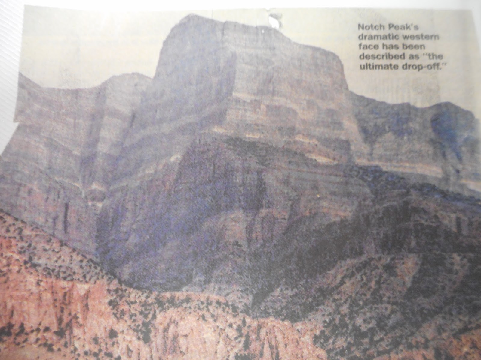
Sheer, steep, lofty, abrupt - adjectives don't do this escarpment justice. John Hart, in his book "Hiking the Great Basin," writes that a Notch Peak climb will refine your use of the word "cliff." It is, he says, "the ultimate drop-off."
A hike to the top begins at the mouth of Sawtooth Canyon, on the mountain's southeast side. A shot-up sign meant to direct motorists to nearby Miller Canyon (the placard on the main unpaved road heading north says " 'er Canyon") sends adventurers west; at a Y intersection, the road on the right heads to Miller, while the one on the left bumps toward Sawtooth.
Sawtooth itself opens with dramatic cliffs. The drainage leading toward the peak turns west then north. The canyon becomes quite narrow, with brushy sides, fallen conifers and a barely discernable trail. Finally hikers head up a ridge toward the peak. Before they get there, though, the mountain suddenly breaks open and YIKES! A massive cleft opens up, a yaw that certainly contributes to the notch visible from scores of miles away. The mountain's limestone foundations swirl in a sequence of sedimentary layers.
From the peak itself, Notch, at 9,655 feet above sea level, drops 5,053 vertical feet on its west side to the bleak but beautiful sagebrush-and-alkali Tule Valley below.
That, as Fergus points out, is nigh on a mile.
Then there's the view from the top: a panorama of desert valleys and distant ranges. On a clear day there are more sights to behold than you may have time to drink in.
"Scenic overdose," two Provo hikers scribbled in a mailbox note.
"I hope you brought your hang glider for an easy descent," wrote Matt and Kristen.
To the east and southeast are Scipio Peak, the Sevier Dry Lake and the Pavant and Tushar mountains. To the south are Utah's San Francisco and Wah Wah ranges. The Confusions are in the immediate western foreground, with the Deep Creeks off to the northwest. Several key peaks can be spotted beyond the Nevada state line - Mount Moriah (elevation: 12,050 feet) and Wheeler Peak (13,061 feet) float far to the west and southwest; Pilot Peak is to the extreme northwest.
And if you hate hiking?
From the northeast, a rugged four-wheel track climbs into the spring-fed Amasa Valley (the locals pronounce it Ama-seh, Fergus adds), past old mining equipment and a collapsed cabin to the Pine Peak overlook. The view toward the Silver State is much the same, without the summit's plunge but with the addition of some nice groves of aspen and pinnacles and boulders of rusty granite.
Near the ridges are enticing campsites, Fergus vouches. His wife loves to stargaze, so he brought her into the area last summer.
"She said she couldn't find the constellations - there were too many stars."
While Notch is gaining a name, some long-time residents of the region are already somewhat famous.
That's "long-time" as in since the Paleozoic, some 400 million years or so ago.
At the S & S Trading Post and Neno's Rock Shop at the west end of Delta, Nina Higgs pulls out a handsome book. There they are: portraits of Elrathia walcott and Ptychagnostus richmondensis (walcott) - two of the 60 species of trilobites found in Utah's House Mountains. Other pictures show creatures found today in such disparate locales as Sweden and Newfoundland.
West-central Utah is famous among rockhounds, Higgs notes. People from all over the world - but especially from the Wasatch Front - visit to seek out topaz near Topaz Mountain to the north, geodes and trilobites. Though long extinct, the latter, small bottom-feeding bug-like animals, are preserved by the millions in Wheeler Formation shale.
The shale is exposed throughout the area. On BLM land, visitors are allowed to chip away at the rock if they want to find a trilobite or two. Collecting is legal, "as long as it's invertebrate" - i.e., no dinosaur bones, which aren't in this vicinity anyway - "and as long as it's not commercial," Fergus says. Technically, then, any discoveries made are not to be for sale, "but it's really hard to enforce; we just don't have the people to do it."
He takes his Blazer off the main track toward gray-green hills. A winding jeep trail leads to a trilobite bed that's semi-secret, though a trench and tons of chipped rock show it has been visited frequently enough. A small pick in hand, within minutes he's revealed a few trilobites: dark, tripartite, scarab-like fossils that look like they could have been embedded there yesterday. Others are found by simply sorting through the debris.
Various BLM and guide maps point the way to such deposits, but few are specifically marked for would-be hounds.
On state parcels - the "school lands" we've often heard about - commercial enterprises are issued permits to excavate. At the U-Dig Fossils pit in Swasey Peak's Antelope Springs drainage, for example, day-trippers are given directions and an opportunity to uncover the ancient creatures.
"That's quite a hole, isn't it," Fergus says. "They've been digging there a long time."
Other beings repose within the rocks as well. Joe Bauman, who writes about science for the Deseret News, heads occasionally to the House Range to look for reddish squiggles that may signify sea life of almost unimaginable age. Trilobites pop out in 3-D; these softer-bodied forms can be more chal-lenging to track down.
"I crack open rocks in hopes of finding some new species of middle Cambrian invertebrate and because I enjoy finding known varieties that are there," Bauman says. The middle Cambrian, approximately 530 million years ago, was a time of great evolutionary diversity.
Some discoveries seem downright alien looking, he says, "like a critter that had seven eyes, paddles and a trunk with a spiky grabber on the end of it." He's sent off several examples to scientists.
For those "who don't want to waste precious time getting there," Neno's offers full- and half-day expeditions into the region, says Nina Higgs. The guides know where the deposits are, provide the vehicle and tools, and bring along water, juices and sanitary accessories.
Rockhounding, she says, is a fast-growing hobby, and "something the whole family can do together." The House Mountains have an open, outdoor appeal in themselves, and the fame of the region's rocks is spreading.
"We see people from all over the world, every walk of life, every nationality."
Like other dramatic Utah settings, the House Mountains tend to make you wish you were a geologist, or at least a better student of the subject.
Great Basin block faulting created the mountains, tipped them up, stretched the valleys and cracked the massive rocks to make narrow canyons. Erosion ate away at the peaks and filled the gaps between then.
"The alluvium in these valleys," Fergus says, "is something like 10,000 feet deep."
All this began some 18 million years ago, according to Halka Chronic's book, "Roadside Geology of Utah," when "stretching, thinning and breaking of the Earth's crust began to create the Basin and Range mountains of western Utah, Arizona, Nevada and California. . . . In Utah, most of the ranges are steeply faulted along their western sides. Geologists soon likened this region to a pile of dominoes all tilted in the same direction."
Another shaper of the landscape was the Pleistocene's Lake Bonneville, the fresh-water ice-age ancestor of the Great Salt Lake that covered vast stretches of territory. The shorelines remain visible along the mountainsides and on hills that were once islands.
Yet another ingredient is molten rock. At some point millions of years ago, magma seeped into the sedimentary foundations of Notch Peak. The intrusion created a becoming red-tinged granite visible in Miller Canyon, the Amasa Valley and on the western side of Notch. And that granite, to prospectors of the 19th and 20th centuries, hinted at precious metals like tungsten, silver and gold, which tend to migrate to the edges of such rock when it is being formed.
And so there are mine claims in the House Range. Some date back a century; others are on state lands: an old wood-and-rock miner's cabin reposes near Sawtooth Canyon; sluice operations continue intermittently in the gravels of Miller Canyon; the Amasa Valley is sprinkled with mine heads and old equipment.
There's no indication anybody hit a motherlode here, so you have to wonder: Did the mine operators get their investment back?
"No, in a word," says Fergus.
But still people have been drawn to the House Range: There's evidence that Archaic Indians were here 10,000 years ago; the Paiutes and other tribes in more recent times; prospectors, cattlemen and cowboys, sheepmen, freight haulers looking for a way through, road builders - and a hermit. Bob Stinson, a World War I veteran, lived in Marjum pass for years and years. In a side canyon he built a one-room home with rock walls under a sheltering cliff.
"How would you like to spend 17 years of your life here?" Fergus wonders.
But rockhounding, hiking, hunting, cave spelunking (Antelope Cave is open during part of the year), hobby mining (as Fergus puts it) and other recreational pursuits seem to be part of the future for these mountains and valleys.
That makes people like Fergus and Higgs a bit apprehensive.
Old-time miners didn't tend to clean up after themselves much, but modern recreationists can be just as careless: You can't help but notice the accumulation of cans and bottles in prime primitive camping spots. ATVs and four-wheel-drive vehicles can do serious damage in such terrain.
"What you get out in this area is someone will cut out into the brush and someone else will come along to see where they went. Pretty soon you have a `road,' " says Fergus, one of whose jobs is to keep an eye on three wilderness study areas in the vicinity.
Higgs, too, expresses concerns about how people treat it, from traveling across the valleys to finding a place to potty.
"In the past five years I've seen it grow so fast. I'm not sad - I'm trying to make a living off it."
Yet, she adds, "People think the desert is forever, but it is fragile."
-By Lynn Arave and Ray Boren and originally published in the Deseret News, Aug. 24, 1997.