Thursday, February 11, 2021

'Moki' Dugway: The most unforgettable/scariest road in Utah, but a view to die for?


The heart of the Moki Dugway switchbacks.
                                                                                                   Photo by Ray Boren in 2018.

WHAT the upper Angels Landing Trail in Zion National Park is to hiking (scariest and most unforgettable), the "Moki" (sometimes also spelled "Moqui" or "Mokee") Dugway is the equivalent to highway driving in Utah.
Often known in San Juan County, Utah as "White knuckle hill," this three-mile-long graded dirt road with an 11 percent grade is unique in the State Highway system, it being a segment of Highway 261, from Mexican Hat to Highway 95 (south of Bear's Ears) or  a shortcut to Hite Crossing on Lake Powell.
This road climbs 1,200 feet up a sandstone cliff face and has no guard rails. The road is also so camouflaged into the cliffs, that you have to almost be on the switchbacks to see them.
The road drops 750 feet in just 440 yards.
"Going up or down is an experience not soon forgotten," is how the San Juan Record newspaper described driving the Moki Dugway on July 24, 1985. The Dugway has become one of the area's spectacular attractions -- and the nearby Muley Point Overlook doubles the eye candy.

Approaching the cliff the Moki Dugway climbs up is almost invisible until you're driving on it!
Photo by Ray Boren in 2018.


Supposedly, the future Moki Dugway slope is where Ute Chief Posey, though wounded, somehow came down the steep mountain and eluded law officers in the 1920s, intent on capturing the Chief for the final Ute uprising.
According to the San Juan Record of July 13, 2005, the Dugway's original name was "Isabelle Hill," though no one seems to know why, or when it switched to "Moki." Why some variations of the name spell it "Moqui" or "Mokee" is also unknown, but the shortest spelling is the norm now by common usage.

                            Even the sign at the top of the Dugway spells it as "Moki" these days.
                                                                                                                           Photo by Ray Boren.

The switchbacks begin at an elevation of 5,325 feet above sea level and top out at 6,525 feet.
The San Juan Record of July 1, 1998 proclaimed the road, "gives new thrills to the driving experiences of the southwest" ... and "provides access to an overlook on top that provides panoramic views of the area."
How did this Dugway come to be?
The Texas Zinc Corporation began to build the Dugway and a total  of 33 miles of road in 1955 from Utah Highway 95 south across Cedar Mesa to Mexican Hat, according to the San Juan Record of Jan. 7, 1965. Plagued by strikes, the road was finally complete in mid-1957 and it provided direct access from the high elevation mines down to a uranium mill at Mexican Hat.
The Dugway portion of the road alone cost $1 million (more than $9 million in 2020 dollar value).
The road was deeded over to the State of Utah in 1957 and officially opened as a state highway on Aug. 10, 1957. Yet, the other portions of U-261 were not paved until 1961-62.


     The Moki Dugway, a gravel segment, is that gap in the red color along Highway 316.


(Texas Zinc Corp. was bought by Atlas Corporation in 1963 and the uranium mill at Mexican Hat closed in 1965.)
San Juan County asked the UDOT to pave the road several times over the decades, including in 1971, according to the San Juan Record on Jan. 21, 1971. However, that never happened and the road remains gravel today.


(To bypass the Moki Dugway means drivers have to go along U-191 from Mexican Hat toward Blanding and then turn left onto U-95 toward Hite. The difference in distance is 30 extra miles without the Dugway, or about 37 minutes extra in travel time.)

The movie, "Chill Factor," (1999) filmed on the Moki Dugway.
Drivers going northwest out of Mexican Hat on U-261 see a high cliff in the distance and wonder where the road goes until the switchbacks come into view. It is likely motor home operators, big rig drivers and those afraid of heights who are unaware of the Dugway, surely question their sanity when they encounter the switchbacks going up or down.
Monument Valley High School  held the "Moki Dugway Hill Climb," a three-mile footrace on Dec. 14, 1991. Newspapers only contain that one single reference to the race being held.

One Google review of the Moki Dugway describes it as an "incredibly scary gravel road like going down the side of the Grand Canyon." Another recommends that only those unafraid of heights drive it, while some others thought it was over-rated.
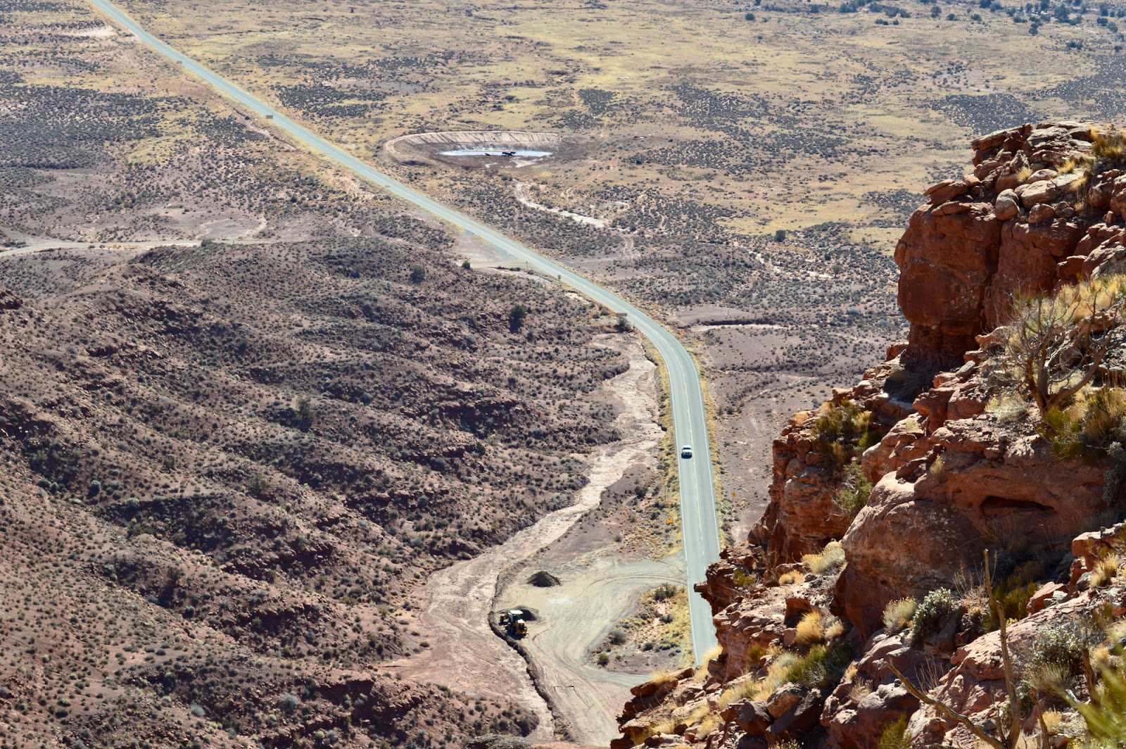

Looking down a portion of the Moki Dugway to U-261 below is like looking out of an airplane.
                                                                                                             Photo by Ray Boren.

-"Skyway prospects delight San Juan" was a Dec. 29, 1968 headline in the Salt Lake Tribune. Reporter Carl E. Hayden stated that there was a plan to build a "sky railway" from the top of the Moki Dugway at Muley Point to Mexican Hat.
People would be shuttled from Mexican Hat and up the Dugway -- about 16 miles -- in buses and then be able to pay to ride a gravity powered cable car about 12 miles straight down as the bird flies to Mexican Hat.
This "would give tourists the breathtaking joy of ascending the Moki Dugway," according to the Tribune.
Of course, the skyway was never built and in today's era, with controversy over increased commercial access to the nearby Bear's Ears area, sacred to Native Americans, the development would probably never happen.

                      Near Bear's Ears, with Navajo Mountain looming in the background.
                                                                       -Photo by Ravell Call.

AT LEAST 5 ACCIDENTS ON THE MOKI DUGWAY:

Yes, people have died on the Moki Dugway. 
1. According to the San Juan Record of May 17, 1989, the first death happened about 1965. A man driving down the Dugway stopped and got out of his truck to urinate at the first turn from the stop. Lonnie Wilson, a passenger in the truck said he heard the driver say, "Oh My God!" from the rear of the vehicle and he was gone. His lifeless body was found on the next ridge below.

2. The newspaper said that scene was nearly repeated in 1989 when Howard Kinlicheeny, age 26, was in a pickup with friends and also stopped to relieve himself. He slipped off the road and fell 40 feet down. He suffered a severed spinal cord and a fracture on his femur.

3. The San Juan Record of May 11, 1994 carried the headline, "Mother dies in one-car accident." Jane Madison Navaho, 21, of Tonalea, Arizona, died when the car she was a passenger in went off the road near the top of the Dugway. She was thrown out of the vehicle after it plunged 60 feet and then rolled over her. Her husband, Dickie Navaho, was injured and had to extricated from the vehicle. The driver, Mary Stephens of Pasadena, Calif., was able to crawl out of the car. She was the only one wearing a seat belt. The Utah Highway Patrol said Stephens was driving too fast and lost control coming down the Dugway's first curve.

4. The San Juan Record of July 22, 1987, in a column by Doris Valle, recounted the tale of a driver who walked away from a fiery crash on the Dugway. Richard Nielson was starting to drive down the cliff's switchbacks in a uranium ore truck, probably in the early 1960s. The truck's brakes failed and then the steering, causing it to go over the first cliff coming down the Dugway. Flames erupted under the hood and Nielson's foot was caught by some crumpled metal inside the cab. The flames suddenly died down and started again, twice, with a few minutes in between. He finally got his foot unstuck and though shaken up, climbed back up the hill to the top of the Dugway. 
He "came up behind two other truckers who stood aghast, looking down at the smoldering wreckage below. They were ready to climb down to find Richard's body when he tapped one on the shoulder, 'What're waiting for?" he asked. "Let's get on down the road!"'

5. According to the San Juan Record of April 13, 2005, a family was almost to the bottom of the switchbacks that year when above them boulders the size of houses came loose and fell on the ledges above. They escaped injury, but a parked road grader higher up the Dugway was damaged by rock fall.


               Hikers to Angels Landing today hang on to chains, anchored to pipes.                                                                                                Photo by Roger Arave.
MORE HISTORY: The Washington County News of Dec. 24, 1925 stated that the first official trail from the end of the road in upper Zion Canyon to the Narrows had been constructed that year. There were 2 different trails, one for hoses and another for pedestrians, leading from the Temple of Sinawava to the Narrows to the Virgin River.
Also, the newspaper stated that the same year, 500 feet of pipe railing had been added "to render the climb to Angels' Landing safe for the timid person." That was something secure to hang on to during the climb up and down the steep path.

                                       Angels Landing with chains.
                                                                                                       Photo by Roger Arave.


Duchesne Tunnel: Utah’s longest water chute

                         View of the west end of the Duchesne Tunnel. in July, with low water levels.
                                                                                                          (Photo by Roger Arave.)


WHEN driving along the Mirror Lake Highway (U-150), it is hard not to look upward at the majestic Uinta Mountain Range. However, BELOW the highway level is a feature just off the highway that most travelers miss …
The Duchesne Tunnel is a six-mile long engineering marvel that is a key to providing water to Utah and Salt Lake counties. The tunnel takes water the south slope of the Uinta Mountains in the Duchesne River drainage and moves it over the mountains to the Provo River drainage and into Deer Creek Reservoir.
  This $9 million tunnel can be viewed at a stop along the Mirror Lake Highway in summer (U-150).
  The stop is signed on both the east and west ends of the highway. However, the west sign is so close to the paved turnout, that motorists may easily pass by and have to turn around and return.
  Watch for it 0.7 of a mile after milepost No. 17, right after the Shady Dell Campground, on the right (south) side of the road for eastbound travelers.
  Although some overgrown trees obscure a good view of it, a 100-foot-long path leads about 40 feet downward to a fenced viewpoint.
  There are also several historical plaques there.
This tunnel required 13 ½ years to build. From delays over a work strike, to World War II manpower and financial shortages, to a disastrous fire, to another strike, this one over safety issues, this project had a lot of obstacles.
One of the first references to the tunnel’s construction was in the Salt Lake Tribune of May 4, 1941. “Work on the Duchesne tunnel also is proceeding rapidly,” the story stated, explaining that 90 men working three different shifts had hollowed out 2,000 feet of tunnel during the approximate first year of work.
WW II temporarily halted work on the tunnel. Yet, a Salt Lake Telegram story of Dec. 30, 1941, stated that the project “is needed to supply additional water for defense developments in Salt Lake and Utah counties.”
Less than a year later, work on the project was at a standstill when a fire destroyed a $100,000 power plant. Machinery and generators were ruined and replacements had to come from San Francisco, according to the Telegram of Oct. 20, 1942.
Next there was a wartime hiatus on work.
The Provo Daily Herald of Jan. 7, 1946 stated that wartime restrictions had finally come to an end and tunnel work would resume soon.
The Daily Herald of June 12, 1946 stated there was a new project problem – a cement lining in the tunnel was now deemed as necessary, raising the total cost by at least $900,000.
Besides having another four miles to do, now the cement meant considerable additional work.
The Herald of May 4, 1947 stated that the Bureau of Reclamation was going to have to call for new bids to finish the remaining 3.7 miles of the tunnel.
The Herald followed on July 3, 1947 with this headline, “Duchesne Tunnel encounters year delay because of bid rejections, but water shortage is not an immediate danger.”
The lowest bid received -- $2.54 million -- was one-third higher than the engineer’s estimate.
After a suitable bid was reached and construction restarted and almost three years later in 1951, there was a major strike over job safety. The Salt Lake Telegram of March 21, 1951 stated that workers claimed “hazardous working conditions” and “unreasonable demands for speed.”
Work eventually restarted, but almost six months later in October of 1951, there were still some 3,000 feet to go in the tunnel boring. The tunnel was extensively inspected and it was estimated that it could be ready for use in 1952.
That estimate was wrong, because the Korean War in 1951 also halted construction.
The Daily Herald of Dec. 6, 1951 reported the tunnel was only 217 feet short of being “holed through.” However, the tunnel was still going to have to be lined with cement and so the completion date was being reset for early 1953.
Workers were getting anxious for completion of the project and they had all contributed $1 toward a pool to guess when the tunnel bore would be completed.
Tragedy also struck in the tunnel project on July 24, 1952, when a worker was killed on the job. Stanley M. Elder, 19, was killed when a slipped into a sand chute and was buried under four feet of earth. The Wasatch Wave newspaper of July 25 reported that workers saw a hand protruding from the sand and summoned help. He was removed within five minutes, but could not be revived.
The Ogden Standard-Examiner of Aug. 4, 1952 carried the headline, “Crews working 3 shifts a day to complete Duchesne tunnel.” Work on lining the tunnel walls with cement had begun June 23. “Workers are now about one-quarter of the way into the giant tunnel and will soon be moving at a 300-foot per day clip,” the newspaper stated.
The Salt Lake Tribune of Nov. 24, 1952 stated that cleanup work was all that remained on what was the longest tunnel ever bored in Utah. However, ample water supplies were likely to delay usage of the tunnel. The last concrete in the tunnel had been poured on Nov. 10, 1952.
The Standard-Examiner reported “6-mile Duchesne tunnel is done” on Oct. 14, 1953. Water that day was turned into the tunnel, erasing any concerns that the Salt Lake Valley would run out of water anytime soon.
This concrete-lined tunnel is 9.2-feet in diameter and goes right through a core of the Uinta Mountains, in a horseshoe-shaped rock tunnel.
 Engineers had used slide rules and non-electronic equipment to design it. One crew started on the west end and another on the east side -- to meet in the middle.
  When they met, they were only a few inches off each other -- an amazing feat of accuracy.
  Some claim the tunnel is so straight, you can look through it and see the other end!
  The Provo River Water Users Association manages the tunnel and its construction was part of the Provo River project.
  The tunnel carries the most water in the spring, the least in late summer and early fall.
A special dam, built in 1952, about 21 miles east of Kamas, supplies water for the tunnel. This tunnel slows or stops flows of the north fork of the Duchesne River at a special control gate.


The Mystery of the Granite Record Facility


THE Granite Mountain Records Facility in Little Cottonwood Canyon contains what is very likely the world's most extensive collection of family records.
Operated by The Church of Jesus Christ of Latter-day Saints, these vaults are encased in the mountain, located about 20 miles southeast of Salt Lake City.
When these vaults, about one mile up the canyon, first opened in 1963, the public was invited for tours. However, by the end of the 20th Century, they were off limits to all but vault workers. The media were also never invited there, likely after the 1970s.
“LDS buys quarry tract as records repository” was a Sept. 29, 1959 headline in the Salt Lake Tribune. The story stated that the Utah Granite Company and Temple Granite Quarries Corporation had sold the land needed for the records vault to the Church. Exact details of the transaction were never made public.
“Church cuts vaults in Granite quarry” was a Jan. 12, 1961 headline in the Salt Lake Tribune. The story reported that some 80 years after the Latter-day Saint Church first began chipping and hauling away granite blocks for its future Salt Lake Temple, the Church was back in the same canyon doing other work with the dominant stone there.
Work had started on the project in the summer of 1960.


The Centennial Development Company of Juab County had the contract to do the excavation in the canyon. The company first drilled a 700-foot exploration tunnel, to be followed by larger tunnels.
President Henry D. Moyle, Second Counselor in the Church’s First Presidency, told Malin Foster of the Tribune that the vaults are being built at the safest known place from disasters in the area for storing records. The rock vaults were also considered an ideal location for the storage of records based on temperatures and humidity.
“Drills deepen sanctuary for Church records” was a May 29, 1961 headline in the Tribune. Staff writer Don LeFevre reported that a crew of 14 men were cutting through granite to create large caverns.
“Their environment is a dark, damp and cool one as they labor on the construction of the vault which will one day house millions of dollars worth of valuable microfilm and documents,” LeFevre wrote.
To that date, the drilling was through some 1,800 linear feet of rock and completed channels measure 27 feet wide and 16 feet high. A total of six portals had been drilled into the mountain, on the north side of the canyon, above Utah Highway 210.
(The canyon road leads to Snowbird and Alta ski resorts. The Church has a historical trail just inside the mouth of the canyon and on the opposite, south side, that commemorates the granite quarry when the S.L. Temple blocks originated from.)
“Crews work in LDS ‘cave’ project” was a Jan. 27, 1962 Tribune headline. By early 1962, crews were done drilling and were pouring cement and deciding the best type of flooring, walls and ceiling for this “cave.” Trenches in the floor had also already been made for future plumbing and electrical lines.
This story also stated that the First Presidency itself chose the site for this granite vault records repository.
“Impregnable storage vaults safeguard LDS genealogical records” was an Oct. 6, 1963 headline in the Ogden Standard-Examiner. This Associated Press story stated that the vaults were originally called “The Little Cottonwood Project,” had cost more than $1.5 million, had been more than three years in the making and was slated for completion in about one year.
There were three 600-foot-long storage vaults, lined with 18 inches of cement and corrugated steel. Three large heavy bank-like vault doors covered the entrances. The three main passages were also intersected by three others, more than 400 feet long and all interconnected.


“LDS grants look-see of tunnels” was a Dec. 2, 1963 headline in the Salt Lake Tribune. Church leaders first toured the new granite vaults. Then selected civic and business leaders had their turn on day number two; and finally on the third day, the general public got to come and take a look on a guided tour. They were titled "Church Records Vault" when they opened. (Their current title is "Granite Mountain Records Facility.")
The Tribune story stated the inside of the vaults were painted in pastel colors and boasted self-contained power, water and ventilation.
The story also said that the vaults were “buried beneath 600 feet of solid granite.
There have been no public updates by the Church on these record vaults. Presumably, they have been updated and likely contain not only original microfilm records, but likely the cutting edge in records storage, including CDs and other high-tech equipment.

-Similarly, the U. S. Air Force had began work on its own Cheyenne Mountain Complex in 1957, inside a granite mountain in Colorado, near Colorado Springs. That much larger vault was not completed finished until 1967, cost more than $142 million and sits underneath an estimated 2,000 feet of granite.

-The Salt Lake Tribune of Aug. 23, 1967 reported that landowners in Little Cottonwood Canyon had dropped a plan to build a housing subdivision at the mouth of the canyon, in favor of constructing a private facility for microfilm and other storage inside the mountain itself. Located just up the canyon from the Church’s granite vaults, they were designed to be similar to those man-made caverns. Today, they are called Perpetual Storage, Inc., located at 6279 Little Cottonwood Road.

-The accompanying illustrations above are some of the images from a mid-1960s brochure, published by the LDS Church on the Vaults.


The beginnings of the Alpine Loop; Plus, the legacy of Bridal Veil Falls


                           The N.E. side of Timpanogos Peak and shelter, near Emerald Lake.

TIMPANOGOS Peak has long been an alluring natural gem for Utah County residents. In fact, the first road to access the base of the mountain was built in 1920. However, according to the Salt Lake Telegram of March 10, 1921, that dirt road “proved unsatisfactory, being too steep and being almost obliterated by heavy rains” in its first season.
The Telegram reported that plans were made in the spring of 1921 to build a better and more durable road to what was then known as “community flat,” likely the top of American Fork Canyon.
It took more than two seasons to construct a new road and the Provo Daily Herald of Aug. 21, 1923 reported that it opened that month as “the most renowned scenic highway in the state.”
The Daily Herald stated that a half-day holiday was declared on Aug. 22 of that year for summer students at Brigham Young University to enjoy the new road – a loop path into Provo Canyon -- that was far less steep than the original route.
“Views which have never been seen before by the auto traveler of the magnetic Timpanogos and its glacier will now be viewed by thousands,” the Herald stated.

          Mountain goats love the rocky edges of Timpanogos Peak.                   Photo by Ray Borten.

Two years later, in June of 1925, the Daily Herald (June 29) reported that a group of Provo residents who were hiking trail to Timp witnessed a tremendous landslide of earth and snow that crossed the trail over which they had just traveled.
The Pleasant Grove Review of Sept. 2, 1938 was one of the first newspapers to use the name “Alpine Loop” for the 15-year-old dirt road. It also stated that the road was closed that month to through travel for a large widening and resurfacing project.
The Salt Lake Telegram of Sept. 19, 1951 recorded that the Alpine Loop was paved later that month for the first time.
Now a paved loop, the Alpine Loop experienced a huge surge in usage for both first-time users, as well as admirers of the fall leaf colors. The Utah State Highway Department had to assign highway patrolmen to the road, to lessen the traffic jams on weekends, according to the Telegram of Oct. 21 that year.
The paved road was also wider, with less sharp turns.
“The vistas of flaming yellows and brilliant reds against the green of fir and pine are literally breathtaking,” the Telegram report stated.
The Tooele Bulletin newspaper of July 17, 1962 reported “Alpine Scenic Loop trip offers many noted tourist attractions.” The world’s steepest tramway (in Provo Canyon), a limestone cave (Timp Cave in American Fork Canyon) and realistic life-size dinosaurs (“Dinosaur World” in Draper) were all claimed as world-class attractions.
The Springville Herald of Oct. 6, 1966, declared the Timp section of the Wasatch Mountains as the “Alps of America.” This newspaper report described the Alpine Loop as “Virgin forest unspoiled by civilization.”
-Most of the Alpine Loop road reports overlooked Bridal Veil Falls in Provo Canyon. However, the first newspaper mention of the falls was in the Salt Lake Herald Republican newspaper of June 29, 1879.
The Deseret Evening News of May 16, 1903 published a large photograph of Bridal Veil and highlighted it as being along the Rio Grande Railroad route.
Ironically, just over a month earlier, the Salt Lake Telegram of April 4, 1903 carried the headline, “Huge boulders fall from mountain top at Bridal Veil Falls, tearing up railroad track nearly 200 feet.”
An army of men had to use dynamite to clear the tracks of gigantic rocks, before they could repair the railroad route.
By 1904, Bridal Veil Falls had become its own tourist attraction. The Denver and Rio Grande Railroad offered a ride from downtown Provo to the falls and back for $1.25 on weekends.
In 1906, a huge controversy broke out when the Telluride Power Company wanted to divert the water from above and generate power there. This led to many petitions to the U.S. Department of Interior to block such a plan – and it was halted.
The Salt Lake Telegram of Oct. 10, 1928 reported that the Provo Kiwanis Club’s plan to build a side road and pullout for up to 15 cars to access Bridal Veil Falls was nearly completed. Then, more than just railroad passengers could enjoy the waterfall.
Jump to 1966 and the Springville Herald of Oct. 6 stated that with an investment of more than one-half million dollars, a skyride above Bridal Veil Falls had become a major tourist attraction in Provo Canyon.
Rue L. Clegg purchased the land surrounding Bridal Veil in 1936 and in 1961, the steepest aerial tramway in the world (the cable was 1,753 feet long and the tram climbed 1,228 vertical feet) opened, along with a cliff top restaurant and gift shop. Some 300,000 riders had taken the tram in its first 5 years of usage.
The tramway continued through the 1995 season, before a fire, an avalanche and a required U.S. Government Environmental Study halted its reopening permanently. Eventually, even the cable and all traces of the tram and buildings were removed.


1906: When Utah had a 'missing' mountain


                                                             The top of Kings Peak.

CAN you lose a mountain?
The Richfield Reaper newspaper highlighted such a supposed mystery in its April 5, 1906 edition and that query cannot be found anywhere else. At the least it highlights how little was known about Utah’s highest summits in the early 20th Century.


“Where is Mount Hodges?” the newspaper asked in a story titled, “The mountain giants of Utah.” It claimed Utah had seven peaks over 13,000 feet in height and that Mount Hodges was the kingpin of them all at 13,687 feet.
“This is about the largest piece of property that has ever been lost, strayed or stolen in a civilized country, and in comparison would make any of the numerous lost mines assume diminutive proportions. A mountain reaching nearly three miles vertical above sea level, unless it has changed its name and is posing under a nom de plume, ought not to be difficult to find. Mount Hodges, the largest unlocated peak in Utah, was named many years ago by Clarence King of the geological survey. While no reward is offered for its apprehension, word of its whereabouts would doubtless be gladly and thankfully received by the residents of the state,” the essence of the Richfield, Utah newspaper report stated.
The old Richfield newspaper story reported that Mount Hodges could not be found on any map. The writer did not list his source for Mount Hodges even existing. Yet, he also listed six other Utah peaks that were believed to be over 13,000 feet – Gilbert, Emmons, Wilson, Lovenia, Tokewanna and Mt. Peale. That’s where the answer to his puzzle is likely found.
Today, a Google or map search yields no Mount Hodges and no similarly named peak that rises over 13,000 feet.
Here’s the actual height in feet and the ranking among Utah’s tallest summits for the six mountains he listed: 3. Gilbert, 13,442; 4. Emmons, 13,440; 5. Lovenia, 13,219; 6. Tokewanna, 13, 165; 9. Wilson, 13,049; and 14. Mt. Peale, 12,721.
What’s missing on that modern and accurate list of tallest summits in Utah is none other that Utah’s highest, Kings Peak, 13,528 and the runnerup, South Kings Peak, 13,512.

                                South Kings Peak.

Could it be that whatever source the Richfield newspaper was using more than 11 decades ago did not have the Kings Peak name, but Hodges instead? Kings Peak is actually named for Clarence King of the U.S. Geological Survey and as the state’s tallest fits this puzzle nicely.
-Notwithstanding the lack of facts in 1906 for those mountains, a much older story in the Deseret News story of Aug. 26, 1874 was more on the mark, but still incomplete.
 The story lamented how neighboring Colorado boasted having six peaks with summits over 14,000 feet, while Utah has none. (In reality, Colorado has 56 named summits over 14,000 feet.)

          Mount Elbert in Colorado, that state's highes peak at 14,433 feet above sea level.

“This beats the best we can do in Utah,” the report by C.R. Savage stated. “Peak climbing is fashionable in that Territory. With us it is not. Visitors to Utah get all their impressions from our city hotels. Very few pierce the hidden wonders of the Wasatch, as seen in Big Cottonwood and American Fork canyons, southward, our Clear Creek, Little Zion valleys, etc.”
What was “Little Zion?” The Deseret News of April 16, 1875 stated, “Those who admire the wonders of nature should pay a visit to Little Zion valley.”

This was one of the very first references to what would become Zion National Park. “Little Zion” was its name then, as some in Utah Territory still thought strictly speaking, Salt Lake City was the true Zion.
Even as late as 1916, “Little Zion” was how the future national park was still referred to. The Washington County News of St. George in its Oct. 12, 1916 edition called it that.


-Access to Zion National Park was also Not a direct route during its early years. The Beaver County News of Oct. 21, 1937 reported on a new $240,000 bridge over the Virgin River that shortened the distance between Hurricane and St. George by 13 miles – and that this also shortened the distance to Zion Park by the same distance.


The story stated the new bridge “makes unnecessary further use of the one of the most tortuous and dangerous dugways in the state.”
The Hurricane Chamber of Commerce hosted a full day of celebration for the new bridge, noting that a new high school, LDS chapel and a culinary water system were all added to Hurricane in the past two years.


One of the first climbs of Mount Nebo -- by horseback, from the west side, in 1887


PERHAPS the first published account of a climb to the top of Mount Nebo, the tallest summit in the Wasatch Mountains, was in the Deseret News of Aug. 3, 1887. And, it was mostly done on horseback from the west side.
"Mount Nebo. An interesting account of the ascent of this majestic peak" was the headline. Dr. Park, J.H. Paul, both of Salt Lake; F.W. Chappell, T.L. Foote, Mr. Noble and Mr. Field, all of Nephi, were the climbers.
This early trek, on July 22, 1887, started at Mona, on the west side of Mount Nebo, in contrast to modern climbs beginning on the east side. The group rode horses up Willow Canyon. They went to about the 6,700-foot level and then rested for the night and continued the morning of July 23. With horses, they were able to easily carry many supplies.


                                               The triple peaks of Mount Nebo.

"Ascending over gravel beds, rocks and drifted soil, through oak-brush, maples, plues and groves of quaking ass, past witches' rocks and over fields of broken, shifting slate,; along narrow trails facing a steep descent of a thousand feet, past great precipitous ledges, and tolling up the last cone-like steep, we reached the apex of Mt. Nebo -- the giant of the Wasatch Range. A cold wind from over several snowbanks saluted and chilled us." the story stated.
"The light atmosphere made the smallest amount of clambering around the mountain very laborious and most of the party complained or headache or dizziness and cold feet. 
While the writer agreed that this Mount Nebo didn't have the religious history of the original peak in the Old Testament, "it far surpasses it in physical grandeur," he wrote.
On the summit, the story stated, "We could see Fountain Green, Moroni, Ephraim, part of Manti, Mount Pleasant, Nephi, Leamington, Moria, Deseret, Goshen, the west fields of Santaquin, Provo, American Fork, Lehi and the cemetery of Salt Lake City."
(The cemetery view seems unlikely, though.)
The group measured the temperature as 24 degrees and saw six-foot deep snowbanks near the summit.
The story ended with, "Altogether, Mt. Nebo is not difficult of ascent, but is not safe to those unaccustomed to the saddle and far too rough and hazardous for ladies. Our train of seven horseman made a pretty sight along the steep serpentine trail, down which some of the Nephi horsemen occasionally rode at breakneck speed."
-MORE HISTORY: "No deer shooting in county this year" was an Oct. 17, 1929 headline in the Weekly Reflex newspaper. This report stated that due to small herds of deer, no hunting would be permitted that year in both Davis and Salt Lake counties. It stated the ban would likely extend for two years.
-EAST CANYON RESERVOIR BEGINNINGS: The Salt Lake Tribune of April 26, 1895, reported how much the east canyon area, about five miles south of Morgan, lended itself as a perfect spot for a dam and reservoir. A 65-foot-high dam was created and it was first filled in 1896, to the delight of Morgan farmers. Today's 260-foot-high dam at East Canyon was built in the early 1960s.
-NORTH DAVIS JUNIOR HIGH SCHOOL opened in the fall of 1939, according to the Weekly Reflex of Sept. 28, 1939. However, the school was not finished until weeks after the students arrived and the newspaper reported that students had to "double up." The cost of the two-story school was $173,000. Students from Kaysville south in Davis County attended there and its initial enrollment was 593.


1941: When many Kaysville street names changed


ANOTHER series of changes in Kaysville City occurred in 1941, when some street names were changed and many were renumbered.
According to the Davis County Clipper of March 14, 1941, Seventh West, also known as Highway 91 became Main Street. Also, Locust Street was retitled as Center Street that year.
"Cemetery Road" was also switched to Crestwood Road and Walnut Street became Third North Street.
In addition, on the west side of Main Street, Sixth Street became First West Street and in order, Second West, Third West, Fourth West, Fifth West and Sixth West closed out a consistent numerical change.
Streets running east of west from Center also became First South, Second South and etc., also in an orderly fashion of titles.


                     200 West and 200 North in Kaysville haven't always been named that,


-BUSINESSES in Kaysville have also changed a lot in 70 years. A featured business listing in the Davis Reflex Journal ("Weekly Reflex") newspaper 20 of the City's main businesses and today only one remains ...
The listing:
Stewart's Gift Shop
Brick Wood Company
Conoco Service
Chick's Barber Shop
Frost Drug Company
Larkin's Tap Room/Lunch room
Davis Farm Co-Op
"91" Cafe
Kaysville Builders Supply
Bowman's 
-Bowman's is the one of the 10 still operating today.

-LARGEST CITY IN NORTH DAVIS COUNTY was how an Oct. 15, 1925 described Kaysville.  The Weekly Reflex of that date also claimed Kaysville had the "Best water on earth."