Showing posts with label Francis Peak. Show all posts
Thursday, February 11, 2021
Hill Field: From wind-swept flat to teeming city in 4 years; Plus, Francis Peak history
A past HILL AFB air show.
"TEEMING City thrives on what was only wind-swept flat four years ago" was a headline in the Ogden Standard-Examiner of Feb. 7, 1943.
"Ogden air depot at Hill Field stands as a monument to the ingenuity, industry and determination of the people of Utah," the story stated. Counter to the former wind-swept land, there now exists there, "a city comprised of huge repair hangars and shops, humming with activity; great warehouses with hundreds of thousands of air corps supply items; administrative office buildings covering many acres; miles of track over which are shunted hundreds of freight cars every day."
Hill AFB from the southeast Layton bench.
The Standard's description continued: "Like any other modern city, Hill Field has many schools, theatres, a chapel, living quarters consisting of both civilian and military barracks, a fire station, cafeterias, utilities, including gas, water and electrical installations, a well-developed police organization, and its own transportation system. ... The physical growth of Hill Field has been prodigious..."
-Nine months later, another newspaper reported on the same transition of former open land in northern Utah: "One time farm area now industrialized," was a headline in the Salt Lake Tribune of Nov. 7, 1943.
The article continued, "Farmers who used to till the soil on a vast expanse of valley land in northern Davis County never thought more about industrial plants or anything which was a very far cry from agriculture."
"Today they gaze at the $22,000,000 rambling air service command headquarters called Hill Field," The Tribune stated.
The article said thousands of workers now work at the base.
(In fact, the area was at one time part of what was called "The Sandridge," a sandy area that was more for dry farming on pioneer times.)
"Hill Field existed as an idea as far back as 1935 ... Sheltered by high mountains, far enough inland to minimize chances of enemy attack, easily accessible by rail and not too far from the Pacific coast," the Tribune story said.
The stated Hill Field was then the nerve center for 12 sub depots in eight states, all of which are controlled and supplied by Hill Field.
"Only 12 miles from Ogden and 30 miles from Salt Lake City, Hill Field grew up in the midst of what was to become one of the most acute labor shortage areas in the war industrialized west," the story stated.
-MORE HISTORY: Another government installation in Northern Utah is the lofty radar station atop Francis Peak in Davis County. "Francis Peak radar unit to begin test basis May 31. Highest radar site in nation" was a May 28, 1959 headline in the Weekly Reflex newspaper. At a cost of $1.5 million, the facility at more than 9,500 feet above sea level is operated by the FAA. It originally included a Utah Air National Guard facility too.
The facility initially had the radar power to see aircraft 100 miles distant and was manned 24 hours a day.
Although a dirt road to Francis Peak was roughed in by 1938, through the efforts of the Civilian Conservation Corps, the Reflex newspaper of June 16, 1960 reported that the Utah National Guard was improving that 5-mile section of road that summer.
Top, center, the Francis Peak radar station.
Monday, February 3, 2020
Road to Francis Peak completed in 1938; The 1940 proposal to run the road all the way to Parley's Canyon
A sign at the top of Farmington Canyon.
THE 5-mile dirt road from the top of Farmington Canyon to Francis Peak was NOT built in the late 1950s when the Francis Peak radar station was constructed. It was built more than 20 years earlier by the CCC (Civilian Conservation Corps) and was completed in 1938.
According to the Davis County Clipper of Sept. 2, 1938, men of the CCC Company No. 940 constructed the five mile road in a two year project. It started as 12-feet wide and the U.S. Forest Service widened it to 22 feet.
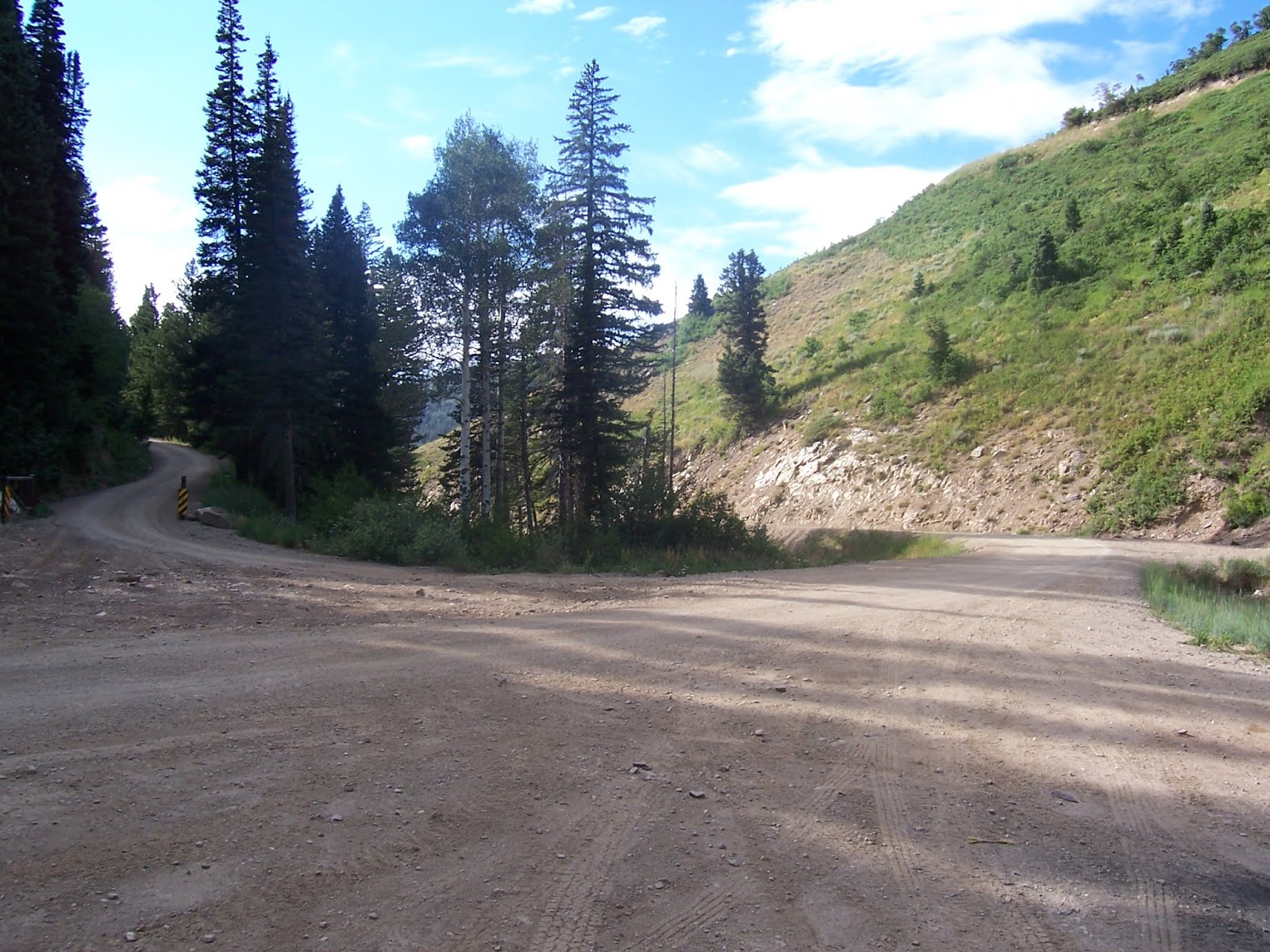
The junction at the top of Farmington Canyon.
"It will open up the scenic beauty around Francis Peak," the Clipper story stated.
The initial purpose of the road was to support erosion control. That's because the Farmington area suffered devastating floods in the 1920s, from overgrazing and also sudden cloud bursts.
An upper section of the road through Farmington Canyon.
The northern radar dome atop Francis Peak.
-That same year, the Salt Lake Telegram newspaper heralded the completion of the entire mountain road, with the headline, "Farmington and Bountiful connected by scenic loop" was an Aug. 31, 1938 headline in the Telegram. This 17 mile stretch was also constructed by the CCC. (The side road north of Francis Peak was a connecting route.)
The road, today's "Skyline Drive," was begun in 1933 by the CCC for erosion control and access. The steepest portion of the road is through Farmington Canyon and that section is 7.5 miles long.
In order to avoid drilling through rock, the Canyon road included two bridges.
The Bountiful Peak Campground and Picnic Area is about one mile south of the top of Farmington Canyon. That facility was dedicated on Aug. 22, 1941, according to the Clipper of Oct. 15, 1941.
Note the switchbacks up the north side of Farmington Canyon.
-It didn't happen, but in 1940, plans were proposed to connect the Davis County mountain road with Emigration Canyon. The Salt Lake Telegram of March 27, 1940, reported the proposal by the U.S. Forest Service. Likely, the United State's entrance into World War II at the end of 1941 doomed that ambitious plan.
However, that tentative road was surveyed as 29 miles long and run along the edge of City Creek and end at Little Mountain in Emigration Canyon. (Originally, the road was to go all the way to Parley's Canyon.)
A view from Layton City toward Francis Peak.
THE 5-mile dirt road from the top of Farmington Canyon to Francis Peak was NOT built in the late 1950s when the Francis Peak radar station was constructed. It was built more than 20 years earlier by the CCC (Civilian Conservation Corps) and was completed in 1938.
According to the Davis County Clipper of Sept. 2, 1938, men of the CCC Company No. 940 constructed the five mile road in a two year project. It started as 12-feet wide and the U.S. Forest Service widened it to 22 feet.
The junction at the top of Farmington Canyon.
"It will open up the scenic beauty around Francis Peak," the Clipper story stated.
The initial purpose of the road was to support erosion control. That's because the Farmington area suffered devastating floods in the 1920s, from overgrazing and also sudden cloud bursts.
An upper section of the road through Farmington Canyon.
The northern radar dome atop Francis Peak.
-That same year, the Salt Lake Telegram newspaper heralded the completion of the entire mountain road, with the headline, "Farmington and Bountiful connected by scenic loop" was an Aug. 31, 1938 headline in the Telegram. This 17 mile stretch was also constructed by the CCC. (The side road north of Francis Peak was a connecting route.)
The road, today's "Skyline Drive," was begun in 1933 by the CCC for erosion control and access. The steepest portion of the road is through Farmington Canyon and that section is 7.5 miles long.
In order to avoid drilling through rock, the Canyon road included two bridges.
The Bountiful Peak Campground and Picnic Area is about one mile south of the top of Farmington Canyon. That facility was dedicated on Aug. 22, 1941, according to the Clipper of Oct. 15, 1941.
Note the switchbacks up the north side of Farmington Canyon.
-It didn't happen, but in 1940, plans were proposed to connect the Davis County mountain road with Emigration Canyon. The Salt Lake Telegram of March 27, 1940, reported the proposal by the U.S. Forest Service. Likely, the United State's entrance into World War II at the end of 1941 doomed that ambitious plan.
However, that tentative road was surveyed as 29 miles long and run along the edge of City Creek and end at Little Mountain in Emigration Canyon. (Originally, the road was to go all the way to Parley's Canyon.)
A view from Layton City toward Francis Peak.
Saturday, July 7, 2018
What are the Names of the Mountain Peaks and Canyons in North Davis County?
THE Wasatch Mountains, east of Layton City, are majestic landmarks most people probably take for granted each day. However, what are the names of the mountain peaks and canyons viewed regularly?
Surprisingly, the majority of the mountain peaks lack official names. Some long-time residents have opted to nickname a few of the nameless peaks. Even some of the smaller canyons are not even titled.
(Officially naming geographical features is often a complicated and lengthy process.)
And, those features that have names, there is usually a story to tell about their titles.
Of course, residents of the City’s east side have a much different view of the mountains than those on the west end.
From Weber Canyon to Farmington Canyon is the width of the main mountainous panorama that most Layton residents enjoy.
Thurston Peak
-Kingpin of those mountains is Thurston Peak, at 9,706 feet above sea level.
However, this loftiest of peaks in those two counties wasn't even officially named until 1993 -- it was previously listed as a benchmark on maps, "Francis VABM" previously on all older maps.
There's now a permanent monument of Utah granite has been erected on the peak with a brass plaque, encased in concrete, that reads:
"Named in honor of Thomas Jefferson Thurston, a Centerville resident who viewed the virgin valley of Morgan from the summit of the mountain in 1852 and recognized its potential for colonization. Realizing its disadvantage was its inaccessibility, in 1855 Thurston influenced others to assist him to carve a passible wagon road through Weber Canyon. He was among the first to settle in Morgan Valley and is acknowledged for bringing about its colonization."
It took a five-month-long effort by the Morgan Historical Society to name the peak in 1993.
The fact was it is named for Thomas J. Thurston is very fitting, because that man and his family had lived in both Davis and Morgan counties as one of their earliest settlers.
It was a June 10, 1992 article, headlined, "Either way you look Francis is Tallest," in the Deseret News, that drew attention to the prominent peak as having no official name and created the spark for it to finally be named.
The view of the top of "North Francis Peak" in 1991, before the peak was named or had a monument on its lofty summit -- it was just a pile of rocks and some posts.
Thurston Peak is also the tallest Wasatch range peak between Willard Peak on the Weber-Box Elder county line and Big Cottonwood Canyon in Salt Lake County.
Francis Peak, complete with two radar domes.
-The other prominent part of the north Davis County section of the Wasatch Mountains is Francis Peak, adorned by two geodesic domes.
Francis Peak was named Francis in honor of Esther Charlotte Emily Wiesbroddt Francis, an early pioneer woman who settled in Morgan in 1863. Her expert knowledge of mathematics, particularly calculus, drew many to seek her help. She assisted early surveyors and, among other things, helped organize Morgan City into blocks, lots and streets.
It was customary in early settlements of the West to name a landmark after a person in recognition of services rendered or contributions made. Sometimes a first name was used. In the case of Francis, her last name probably sounded like a better name for the most prominent mountain peak in the area than her first name.
Brigham Young himself is reported to have honored Francis by naming the mountain after her.
Francis Peak was once Davis County's craggiest mountain summit. However, some 22,000 cubic yards of material and 32 feet of the peak's height were removed to level the site for the radar domes.
While most maps list Francis Peak's elevation at 9,547 feet, that was its original height and doesn't account for the loss in height during the $2 million construction in 1958-59.
The natural height is now 9,515 feet, making it the fifth-highest peak in the county. The facility's base adds 55 feet and the radar domes chip in another 60 feet for a total of 115 feet in artificial height - making the peak, some could argue, 9,630 feet above sea level.
The FAA originally wanted to locate the radar site above Salt Lake City, near Alta or Snowbird. But the National Guard was already using a temporary facility at Francis Peak, so that became the joint location.
Workers at the peak's construction site had to wear thick, long boots and carry sticks or pistols: Although snake experts said the reptiles can't live that high, someone forgot to tell the rattlers.
There were numerous nests of rattlesnakes uncovered in the building process, despite the site's almost 2-mile-high elevation.
In the late 1970s, a tramway was proposed as a quicker and more convenient access up Shepard Canyon to Francis Peak than traveling up Farmington Canyon. However, the FAA's approval for the site got caught in environmental red tape and never became a reality.
"Layton Peak," center.
-For some unclear reason, only two of the 10 highest peaks in Davis County have names - at least official monikers approved by the Utah Geographic Names Committee.
-“Layton Peak” (unofficial name) is the first peak to the left, or north of Thurston Peak and is 9,571 feet above sea level. This peak is also tied with another unnamed one to the north as the second-tallest summit in Davis
County.
“Layton Peak” is 0.7 of a mile north of Thurston
Peak and lines up with Antelope Drive. Like most tall
peaks in Davis County, the “Layton” summit also
straddles the Davis County-Morgan County line.
The “Layton” Peak rises approximately one vertical mile away the valley floor.
Over time, popular usage of such geographical nicknames often become the standard, official titles of unnamed features.
-“Ed’s Peak,” an unofficial title, was named after Ed Ford, who lived in a hollow down below in Kaysville, east of the City Cemetery.
-Note that “Bair” is the correct spelling of the canyon and creek. John Bair was the namesake of the two natural features, but his name has been misspelled “:Baer” and even “Bear” at times, (See the Deseret News of Dec. 29, 1995 for a full explanation.)
-In addition, there are three small lakes — Smith Creek Lakes — hidden on the east slope of the Wasatch Mountains east of Layton and Kaysville. (A jeep trail , the right fork just past Bair Canyon, leads to these secluded bodies of water.
NOTE: By Lynn Arave and previously published in "Layton Today," by Layton City and the Davis County Clipper.
SOURCES: Deseret News Archives, USGS Maps
Wednesday, December 6, 2017
1937: When the Skyline Drive, between Farnington and Bountiful, opened
THE Skyline Drive/backway mountain dirt road, between Farmington and Bountiful, Utah, first opened on August 29, 1937.
"Connecting last link and route of new mountain highway" was an Aug. 31, 1937 headline in the Davis County Clipper newspaper.
For the first time on Aug. 29 that year, an automobile traversed the entire 27-mile stretch between the two cities.
James E. Gurr, supervisor of the Wasatch National Forest and J.P. Martin, regional engineer for the Forest Service in Ogden were the first two to travel the road.
The road was built by CCC crews and transient labor, over five years, from 1933-1937. Besides the scenic nature of the road, it also gives firefighters easy access to the area.
The Farmington Canyon portion was stated in the story as the most difficult. Drilling was required through solid rock to create thjat 7.5-mile portion of the road -- most of it "on a precipitous and rocky hillside." Two bridges over Farmington Creek were also required there.
The road tops out at 9,150-foot above sea level in the Bountiful Peak area.
Farmington Canyon can be blocked by snow well into summer.
The road was also built because of the flooding problems in the area during the 1920-1930s time period. Erosion control dykes were also established, to better control runoff.
-The Sunset Picnic/Campground area in Farmington Canyon was dedicated on May 23, 1939 by the U.S. Forest Service. Located six miles up the Canyon, the area was previously the Farmington junction camp, used to camp road workers.
The FAA's portion of the road to Francis Peak.
-According to the Davis County Clipper of Dec. 6, 1968, a section of road off the Skyline Drive was planned to go down into the Morgan area, on the east side of the Wasatch Mountains. However, that was never built.
It was also hoped that there could be a ski resort established on Farmington Flats. That never materialized either.
-An aerial tramway was also planned up Shepard Canyon to Francis Peak in the 1970s. Although there was little opposition to this plan (Davis County Clipper Aug. 5, 1977), it also never happened.
Original funding was $1.1 million for the tram and it would have been able to carry up four men and 3,000 total pounds. The tram ride would have taken but seven minutes, as compared with 1.5 miles to drive the dirt road to the Radar Domes. It would have featured 12 towers up the mountainside, to the 9,500-foot elevation summit.
The tramway was considered very cost effective, as compared to keeping the dirt road passable all winter. In fact, the study showed the tram would have paid for itself in eight years, since the Francis Peak station is manned year-round.
The tramway plan's environmental study got bogged down in its own federal red tape and its construction costs skyrocketed and mean the project never happened.
The junction up Farmington Canyon, where the road splits, north to Francis Peak or south to Bountiful Peak.
-All photos by Roger Arave.
Thursday, October 10, 2013
Davis County's Lonely Outpost: Francis Peak
The north radar dome. You can't get this close anymore, because of a fence.
Francis Peak as viewed from part of the Skyline Drive road.
By Lynn Arave
FRANCIS Peak is undoubtedly the most changed Wasatch mountain peak in the Top of Utah since pioneer times.
Located east
of Fruit Heights in Davis County, Francis Peak was once one of the craggiest
peaks in the area. It was also among the first Davis and Morgan County peaks to
be identified.
The peak, which straddles
Davis and Morgan counties, was named Francis, at the suggestion of Brigham
Young, in honor of Esther C.E. Francis (1836-1913), an early pioneer woman who
helped settle and survey Morgan in 1860s.
“Our
Heritage: Samuel and Esther Francis,” describes it this way:
“Rising
majestically above Morgan Valley to the west of the Wasatch Mountains, one of
its highest peaks bears the name ‘Francis Peak.’ Snow capped and glittering in
the sun in the day and lit by two artificial lights by night it stands as a
lighthouse in the sky to be seen for many miles.”
With
two manmade radar domes sitting atop Francis Peak today, it looks far different
than it did before the late 1950s.
The domes, operated by the Federation Aviation
Administration and the Air National Guard, provide long-range radar and
identification for area aircraft. Its radar range is 250 miles outward and up to 100,000 feet straight up.
At first, the FAA wanted to
install such a radar site near Alta or Snowbird. However, because the National
Guard was already using a temporary facility at Francis Peak, that became the
logical, joint location.
Otherwise, according to the Salt Lake Tribune of Sept. 26, 1958, Francis Peak was only initially planned to have a National Guard Installation. That story states that Francis Peak's original elevation was 9,547. After the facility was completed, counting the artificial structure, it dropped by 32 feet to 9,515.
Workers atop Francis Peak had to
wear thick, long boots and carry weapons. Rattlesnakes are not supposed to live
that high, yet someone forgot to tell the rattlers that. Numerous rattlesnake
nests were uncovered during construction, despite the almost 2-mile-high
elevation.
In fact, according to the Standard-Examiner of Sept. 26, 1958, almost 100 rattlesnakes had to be killed by workers during the construction. Two workers were bitten and both survived.
Some workers also claimed that Copperhead rattlesnakes were killed at the work site.
A Standard-Examiner story from Sept. 21, 1958 stated that rattlesnakes were killed at the rate of two or three a day during the construction process.
"Morgan County sees new stars (Radar Unit Lights) atop peak" was the headline of this story. It also reported that sand and gravel trucks came from the Bountiful end of the mountaintop "Skyline Drive" (not through Farmington Canyon) and that it took six hours for such trucks to make the trip.
Approximately 22,000 cubic yards of material and nearly a dozen yards of the peak's height were removed to level the summit. This $2 million construction project, in 1958-59, also included helicopters flying in 33 gigantic metal poles, weighing 800-1,000 pounds each, to shore up a foundation.
In fact, according to the Standard-Examiner of Sept. 26, 1958, almost 100 rattlesnakes had to be killed by workers during the construction. Two workers were bitten and both survived.
Some workers also claimed that Copperhead rattlesnakes were killed at the work site.
A Standard-Examiner story from Sept. 21, 1958 stated that rattlesnakes were killed at the rate of two or three a day during the construction process.
"Morgan County sees new stars (Radar Unit Lights) atop peak" was the headline of this story. It also reported that sand and gravel trucks came from the Bountiful end of the mountaintop "Skyline Drive" (not through Farmington Canyon) and that it took six hours for such trucks to make the trip.
Approximately 22,000 cubic yards of material and nearly a dozen yards of the peak's height were removed to level the summit. This $2 million construction project, in 1958-59, also included helicopters flying in 33 gigantic metal poles, weighing 800-1,000 pounds each, to shore up a foundation.
I’ve been inside the Francis Peak
facility twice over the years on media tours and it is a high tech, lofty
outpost, complete with a kitchen, bedrooms and its own water supply.
(Its “twin,” of sorts is the
TV/radio transmitter facility atop Farnsworth Peak in the Oquirrh Mountains.)
How tall is Francis Peak? That is
a loaded query.
U.S. Geological Survey lists
Francis Peak as 9,547 feet above sea level. However, that was BEFORE the 1950s
construction.
The natural height there now is
9,515 feet. The base of the facility's base adds 55 feet and the domes chip in 60
feet more for a total extra artificial height of 115 feet and a grand total of
9,630 feet above sea level.
(Thus, only Thurston Peak, located
about four miles north, is “taller” in Davis County than that - at 9,706 feet.)
The FAA uses special rotary snow
blowers to keep the dirt road to the radio domes accessible year-round, since
it is manned continually. However a 17,000-foot-long tramway access was
proposed to be constructed up Shepard Canyon in 1977. Environmental red tape
delayed and eventually doomed this project.
The Civilian Conservation Corps
(CCC) built the Farmington Canyon-Bountiful Peak road, from 1935-1939. This
26-mile loop road first opened to the public in July of 1939. Some 50 years of
overgrazing had produced disastrous flash floods on the mountainside in both
1923 and 1930.
The dirt road was built to aid access for the
approximately 80 men of Bountiful CCC Camp No. 910 to construct flood control
terraces and seeding projects from Parrish Canyon on the south to Farmington
Canyon on the north.
Perpetually, the road was designed
to help the U.S. forest Service keep erosion and wildfires under control. The
bonus was opening up the scenic beauty to public access.
Workers and sheepherders also reported
rattlesnakes at unusually high elevations there in the late 1930s.
The Sunset Campground at
6,200-foot elevation in Farmington Canyon opened in 1939, while the Bountiful
Peak Campground, at 7,500 feet, was dedicated in 1941.
Steep grades, narrow curves and
sheer drops still test the nerves of timid drivers along this road, officially
called, the “Skyline Drive Scenic Backway,” today.
When construction on the radar domes took
place in the late 1950s, the FAA built the additional 5-mile dirt road
northward, from the top of Farmington Canyon, to Francis Peak.
A jeep trail continues north from
the radar domes and eventually swings to the backside of the Wasatch Mountain
to access the three Smith Creek Lakes on the Morgan side.
Francis Peak is a popular summertime scenic backway destination in Davis County, offering access to the Sunset and Bountiful Peak campgrounds as well as the most spectacular bird's-eye views possible of the Great Salt Lake.
The road to the lofty radar domes that top the peak is officially known as Skyline Drive. It begins on Farmington's 100 East. It is paved for the first mile and then follows a winding, narrow dirt road for another 12 miles. Most cars can make this bumpy journey, though it is a back-country road.
There's a fork in the road at the top of the canyon, about eight miles up. The right (south road) leads to Bountiful Peak and eventually Bountiful's east bench, some 19 miles later.
The left road (north) heads to the radar domes operated by . A gate on the left fork is closed during snow season because of dangerous snow removal equipment.
Snow banks along the upper reaches of the road - 9,000-foot plus elevation - continue until mid- to late July. On a clear day, even the High Uintas are visible to the east.
A popular hike goes along a jeep trail northeast of the radar towers to the Smith Creek Lakes.
Prior to 2002, you could drive, or walk right up to the radar domes. Now there is some fencing and enhanced security to better protect the facilities there.
-The Farmington Canyon road leading to the Radar Domes has a ahistory of its own. According to the Ogden Standard-Examiner of Sept. 1, 1937, the origin of the road dates back of 1936. In its first two years of construction, 64 tons of dynamite; 33,000 gallons of gasoline and 26,069 man hours were required for the road's initial development -- and that was used for just the first 7.5 miles of the road up the mountain.
The road was lengthened and improved many times, eventually going the 26 miles to Bountiful. A spur road, five miles to the north was created in the late 1950s when the Radar Domes were constructed.
-The Farmington Canyon road leading to the Radar Domes has a ahistory of its own. According to the Ogden Standard-Examiner of Sept. 1, 1937, the origin of the road dates back of 1936. In its first two years of construction, 64 tons of dynamite; 33,000 gallons of gasoline and 26,069 man hours were required for the road's initial development -- and that was used for just the first 7.5 miles of the road up the mountain.
The road was lengthened and improved many times, eventually going the 26 miles to Bountiful. A spur road, five miles to the north was created in the late 1950s when the Radar Domes were constructed.
Note: Lynn Arave has actually had a tour inside the radar domes twice. Once in 1980 and again in 1998.
(Published in the Ogden Standard-Examiner on Aug. 1, 2014.)
-NOTE: The author, Lynn Arave, is available to speak to groups, clubs, classes or other organizations about Utah history at no charge. He can be contacted by email at: lynnarave@comcast.net
Saturday, November 3, 2012
Do Mountain Peaks Change?
The rugged backside of Mt. Ogden Peak today.
MOUNTAIN Peaks do change substantially over just a few decades, thanks to man.
This means history-wise, mountain peaks can change more rapidly than some of the natural landmarks in the valley below.
Take Mount Ogden, the tallest peak to the east of Ogden, Utah, at 9,572 feet above sea level.
In 1988, the peak had one small metal plaque and a single, narrow transmitter tower on its summit.
(See the 1988 photo below.)
That was the year when Weber State University's "Flaming W" fall hike to the top of Mount Ogden was revived. (I had pretty good video footage of that event.)
By 2010, 22 years later, there was an array of transmitters installed on the peak, as well as a cement helicopter pad.
You sat on rugged rocks when visiting the peak in the 1980s.
Today, it is cool to rest of a flat cement pad.
Back in 1988, there was no dirt road up the final approach to Mt. Ogden -- you had to scramble all the way up. There was a dirt road to the dip between peaks, to the south, but that's where the road ended.
(Note the newer, color photos below that show the many transmitters and the cement landing pad.)
Certainly some would argue that the many transmitters there now pollute the peak.
However, they comprise cell phone transmitters, emergency transmitters and even Utah Transit Authority repeaters. Without them, outdoor users in the area would probably receive no cell signal.
Also, emergency communications in the valley below would be spotty, making it less safe to help those in medical or emergency need.
Even the name of Mount Ogden has changed over the decades.
Dr. A.B. Condon of Ogden succeeded in getting the name of what had been called Observatory Peak since the 1870s, changed to Mount Ogden Peak in 1920.
--And, in Davis County, to the south, there is even a much more changed peak -- Francis Peak.
Although most maps list Francis Peak as being 9,547 feet above sea level, that was BEFORE the radar domes were constructed on its summit, during 1958-1959.
Built at a cost then of $2 million (more than $16 million in 2012 dollars), the facilities removed 32 feet in height from Francis Peak and forever changed its appearance.
So, you might argue that Francis Peak is only 9,515 feet tall now -- at least the rock portions are.
However, the radar domes add another 115 feet in artificial height and so a satellite GPS would measure the peak's elevation at more like 9,630 feet above sea level.
That's not enough to rival Thurston Peak (9,706 feet above sea level) as the highest peak in the area, though.
What I would love to find someday is a photograph of how Francis Peak looked BEFORE 1958, when it was still in its natural state.
Subscribe to:
Posts (Atom)


.jpg)